My 6 word autobiography: Seeking ways to make a difference. This blog provides more information packed comments than possible in blog comments. I'm not an expert in any field but interested in many. Content is open to correction if needed.
I think it was wonderful to see your post about the Veterans in your families. We also remember on November 11. Here in Australia, we call November 11, Remembrance Day and hold services around the country at 11:00 a.m.. Next year, Remembrance/Veterans Day will mark 100 years since the end of World War I.
Another day to remember here is ANZAC Day held on April 25 each year. With Australia only becoming a nation in 1901, the Australian and New Zealand Army Corp (A.N.Z.A.C.) landing on the beaches of Gallipoli on April 25, 1915 was the first time Australian forces were involved in a war as Australians. Before January 1, 1901, Australia was a country of six British colonies, now the six states of Australia.
While I didn't have any close relatives in the U.S. Armed Services, I thought I'd share some of my relatives who served in the Australian Armed Services.
This photo should not be used or copied without written permission.This photo should not be used or copied without written permission.
Great Uncle Ernie (he was my father's uncle) - When World War I broke out in 1914, he was in the Australian Naval Reserve and was involved in one of the first actions of the war when Australian forces took German held islands in the Pacific near Australia. Leaving the Naval Reserve, he later joined the army and was sent to the war in France. He was one of the very many never to return to Australia.
This photo should not be used or copied without written permission.
Uncle Andy served in the army during World War II. During his time in the army, his best friend was my father. They both were P.O.W.s with the Japanese forces when British Forces in Singapore surrendered in 1942. With the end of the war in 1945, they were able to return home. It was while visiting his best friend after the war my father met the woman who became my mother.
This photo should not be used or copied without written permission.
Uncle Gordon (right) served in the RAAF (Royal Australian Air Force) during World War II.
This photo should not be used or copied without written permission.
This is my father. The photo was taken on the streets of Sydney in 1945 after he returned from the war.
I had other uncles in the navy and army during World War II but don't have photos of them in uniform. All of my uncles are no longer with us. Had my father still been with us, he would have been 98 years old.
Each Remembrance Day and ANZAC Day I remember my father, uncles and others I knew who served in the Australian Armed Forces.
I'll start by repeating the wonderful quote from Henry Miller at the beginning of you post...
The moment one gives close attention to any thing, even a blade of grass it becomes a mysterious, awesome, indescribably magnificent world in itself.
~Henry Miller
I saw your post entitled "The Power of Observation and Wonder" and found it very interesting to read. I was going to write a reply because, as the previous Global Grade 3 class knows, I am interested in many things including stones but I have been very busy filming and making DVDs for schools. However, your "A Closer Look at MAPS!" post again caught my attention so I thought I'd write a short post about maps.
I have seen many types of maps including the types you have studied. Perhaps my favourite modern maps are the types I used as a Scout. I would say, "Give me a good map and a compass and I can usually find my way around."
I have scanned an old topographical map I used in the 1970s. It was measured in miles and feet but we were changing over to kilometres and metres around then. Have a look at the map. Click on it to see it larger...
This is a scanned section of Central Mapping Authority of N.S.W. topographical map printed in 1970. I do not hold copyright over this image.
The map has a great deal of information. I can see red lines showing roads. Some roads are shown as white with red dashes to show they are dirt roads. There are thick black lines with small, double dashes along them to show a railway line. Blues lines show rivers and creeks. We can easily see Blackheath is a town but there are large areas without streets and those areas interest me as I have explored those areas.
Can you see the brown wriggly lines on the map?
The brown lines are contour lines. They show heights. Each line shows a height of 50 feet more or less than the next. Some of the lines have numbers such as 3200. The 3200 tells me at that place the land is 3200 feet above sea level. Looking at the numbers and the lines can tell me if I will be going up or down when hiking. Let's look closer at a section of the map...
This is a scanned section of Central Mapping Authority of N.S.W. topographical map printed in 1970. I do not hold copyright over this image.
I have added the red numbers to help students find specific points.
See the black, single dashed lines?
They are walking tracks I have followed. I have walked down from number 1 to 3 and up from 3 to 2.
1 - The beginning of the track is about 3250 feet above sea level.
2 - The end of the dirt road is about 3200 feet above sea level
3 - Beachamp Falls is about 2650 feet above sea level.
The map shows me if I walk down from 1 to 3, I will drop 600 feet. If I then walk up to 2, I will go up 550 feet. Because the brown lines are close together, I know the track will be steep in places.
Do you notice one section is named Grand Canyon?
It's not even close to the size of the Grand Canyon in U.S.A. but it is steep sided.
Let's look at some photos I had taken around 1980 in the Grand Canyon and at Beauchamp Falls.
Starting down the steep track from 1.
Schools and students have permission to use this graphic for non-commercial, educational purposes.
We pass through a small tunnel and behind waterfalls.
Schools and students have permission to use this graphic for non-commercial, educational purposes.
Deep down in the Grand Canyon.
Schools and students have permission to use this graphic for non-commercial, educational purposes.
Until we reach Beauchamp Falls at 3.
Schools and students have permission to use this graphic for non-commercial, educational purposes.
And now for two photos for your "The Power of Observation and Wonder" post. The photos show rocks that caught my eye but were left in place. They were in a national park so we are not allowed to take them. They were also far too big to carry.
The first shows a large sandstone rock.
Can you see the black mark?
It is the remains of a tree trunk buried under sand millions of years ago but now exposed after a rock fall. It is a fossil record of the tree.
Schools and students have permission to use this graphic for non-commercial, educational purposes.
The second shows an even larger sandstone rock.
Do you notice the ripples on it?
Millions of years ago sand was rippled by flowing water. A thin layer of mud covered the ripples and in time left a fossil record of water running over sand.
Schools and students have permission to use this graphic for non-commercial, educational purposes.
What is even more amazing is this sandstone was sand under the sea millions of years ago but it is now lying 2650 feet above sea level. These rocks of sandstone certainly caught my eye and the eyes of the children I had taken there as we thought of their long history.
When we then walk the 550 feet in height (but much longer along track) back up to 2, this is what we see when looking north.
Schools and students have permission to use this graphic for non-commercial, educational purposes.
...and now your interesting questions...
How long does it take to study a place and then make the map?
For early map makers, they might have to walk, ride or travel by ship in order to make maps so it could take a long time to make a map.
Back in August 1768, Captain James Cook set sail from England. He was taking scientists to Tahiti to observe Venus crossing the Sun. Once the scentists had finished their observations, Cook's orders were to sail south to find Terra Australis Incognita, the unknown southern land, some people thought must exist.
In September, 1769 he reached New Zealand and set about mapping its islands.
In April 1770, he reached a land he named New South Wales. It was really the east coast of Australia. He sailed north along the coast mapping as he went. Cook and his ship didn't return to England until 12th July, 1771. It had taken him and his crew three years to make the journey and return with the maps he had made.
Schools and students have permission to use this graphic for non-commercial, educational purposes.
Today, with satellites, GPS and Google Earth, we can map the world from our own homes.
How many different kinds of maps are there?
Interesting question and makes me wonder what a map might be. We know most types but is a plan for a house a map? Is a design for a new machine a map? They also show where things are.
Are there maps about SPACE?
Now this is complicated. In your post , you noticed the maps you saw were two dimensional flat maps. In order to find a place on a map, you needed to know how far up or down and side to side a place is.
To accurately map space, we would need a three dimensional map and it would have to be huge because space is huge. Using computer models, there are space maps. Here is a link to a 3D space map animation representing 400,000 galaxies. Remember our Sun is just one star amongst possibly hundreds of billions in just one of those galaxies.
Of course, pilots in early days didn't have computers. They would look down to the ground and possibly follow roads or railways to their destination or they might use a compass so an old fashioned paper might might have helped.
Do we have maps for EVERYTHING?
WOW! Maps of everything? Even on our own Earth there are places no one has ever been so, for example, there are no accurate maps for some of the deepest places in our oceans. What about other planets, stars, galaxies? We may not have maps for everything but we do have maps of very many things but there is still so much more waiting for someone like you to map.
What jobs need maps?
Cartographers (map makers), pilots, sailors, explorers, delivery drivers, police, ambulance, fire fighters, tow truck drivers... There would be so many jobs where we might need maps at some time.
These maps were sourced through Wikimedia Commons where they are listed as in the public domain.
The first shows the world as known by the Greeks perhaps 3000 years ago. It shows the Mediterranean Sea.
The 500 BC map from around 2500 years ago shows the Red Sea and the opening into the Atlantic Ocean.
By 150 AD Europe, parts of Africa, and Asia has appeared on the maps. Notice Terra Incognita at the bottom right of the map. It's what Captain Cook was sent to find or show wasn't there.
How many countries are there in the world?
Interesting... The United Nations has 193 countries as members. My blog has had visits from 193 countries and I have seen 196 listed as the number of independent countries in the world. Here is a link for you...
Do maps ever change? (This one brought up some VERY interesting conversations around Bombay, Calgary, Nunavut and the NEW islands that VOLCANOES create!!!)
Maps have to change when what has been mapped changes.
Yes, volcanoes can create new islands.
You know about the big island of Hawaii. Did you know deep under the ocean around 30 kilometres south of The Big Ilsand there is a new volcano rising around 10,000 feet from the ocean floor with only about 3100 feet before it reaches the surface? If in the future it does break the surface, Hawaii will have a new Island.
The islands of Hawaii were formed in this way and will eventually erode into the ocean as many have already done over millions of years. Look at the Google Earth image below. The Hawaiian Islands are in the middle at the bottom. Look carefully and you can seen now submerged volcanoes moving off to the left as you go north. They may once have been islands as is Hawaii.
When we have changes in the level of the sea, land also changes. In times of ice ages, sea levels can be much lower and expose more land. When the first people came to Australia around 30,000 years ago, they were able to walk from New Guinea into Australia and cross to Tasmania by land. Now you would need boats.
The opposite happens when sea levels rise. Some islands in our oceans are now underwater but were once above. It worries island nations in the Pacific and Indian Oceans.
Another country I find interesting is the Netherlands (Holland). Over generations, they have taken back land from the sea using dykes and sea walls. In the news recently there have been stories of islands being built by the Chinese government in the South China Sea.
And in your own part of the world, when new suburbs, roads, streets, airports, railways, etc are built, maps need to change.
Do maps ever change? They have to if they need to be accurate.
I'll end with a quote, not from some famous philosopher or writer but from a character in the movie, "Superman", released in 1978...
“Some people can read War and Peace and come away thinking it’s a simple adventure story. Others can read the ingredients on a chewing gum wrapper and unlock the secrets of the universe.” – Lex Luthor
Both your quote at the beginning and this at the end tell me the key to learning is to keep our minds and senses open to all around us for, if we do, we will begin to see our world and those beyond as containing mysterious, awesome and magnificent opportunites just waiting to be discovered.
OH DEAR!
At the beginning I said I'd write a short post about maps. I do get carried away when I see something as interesting as your posts. 🙂
I found this post to be interesting as it shares a few things of interest to me. Looking at Memorial Day, Australia's equivalent would be ANZAC Day held each year on April 25. It's a day when Australians remember those men and women who have served our country in war.
Bega Soldier's Memorial
Schools and students have permission to use this graphic for non-commercial, educational purposes.
A Little ANZAC History
This year, 2015, held special significance for Australia and New Zealand because it marked the 100th anniversary of the day the ANZAC tradition began. Firstly, ANZAC is an acronym coming from Australian and New Zealand Army Corps. It's a word used to describe the combined forces sent by New Zealand and Australia to help England in World War 1 (WW1).
Australia had only become a nation in 1901 when the British colonies, now our states, agreed to form the Australian Commonwealth, i.e. Australia as a nation. With England's declaration of war against Germany in WW1, the Prime Ministers of Australia and New Zealand also declared they were at war with Germany. This was to be the first time Australians had gone to war as Australians.
Ships set sail from Australia and New Zealand with troops expecting to fight in Europe against Germany but a failed attempt to use naval strength to take the Ottoman Empire, and ally of Germany now known as Turkey, out of the war, ANZAC and other troops of the British Commonwealth were sent to the Gallipoli Peninsula then known as Çanakkale Savaşı to the Turkish. It was on April 25, 1915 ANZAC troops first landed at Gallipoli.
The Battle of Gallipoli (Çanakkale) lasted from April 25, 1915 until January 9, 1916 when British troops including the ANZACs withdrew from Gallipoli. There was huge numbers of soldiers killed on both sides of the battle where conditions were very poor for soldiers, many also dying of disease.
For the ANZACs, it may have been a defeat but it marked the beginning of a tradition. ANZAC Day each April 25 is a time when Australians and New Zealanders pause to remember those who have died in wars from that first battle up until modern times.
What did I do on ANZAC Day, 2015?
A few years back, I set myself a task of filming the ANZAC Day ceremonies in towns having one of the local schools in our Sapphire Coast Learning Community including 2 high schools and 13 primary (elementary) schools. I knew it was a task that would take a number of years as I didn't expect to finish until 2018. the 100th anniversary of the end of WW1.
My ANZAC Day this year started at 4:30 a.m.. I rose and headed down to the memorial in my town of Merimbula in order to set up a video camera to record what is known as the Dawn Service. The Dawn Service ended a little after 6:00 a.m.. I haven't as yet processed the video of The Dawn Service so I can't yet share it here but the photo below was taken during the service.
Merimbula Dawn Service
Schools and students have permission to use this graphic for non-commercial, educational purposes.
After returning home for breakfast, I next headed into our main shire town of Bega for the ANZAC Day March and Ceremony. It was only after this ceremony my ANZAC Day ended. I returned home by 1:00 p.m..
Below are two video clips I made of the Bega ANZAC Day march and ceremony. They were used in a DVD I gave to schools in Bega and members of the R.S.L. (Returned Services League for veterans).
Bega ANZAC Day March and Ceremony part 1 and 2
Do I have anyone in my family who had served in the military?
Before WW1 started, I had a great uncle (my father's uncle) who was in the Australian Naval Reserve. With decelaration of war against Germany, naval reservists were called up and sailed north in order to capture Germany territories around New Guinea. That means my Great Uncle Ernie was in one of the first battles of World War 1.
Great Uncle Ernie taken in 1915
Permission should be sort before using this image.
After taking over the German colonies, my great uncle had returned to Australia and had resigned from the naval reserve. He was later to join the Australian Army and was sent to fight in Europe. He was killed in action over there but exactly where he lies isn't certain. He was one of the many unknown soldiers.
With the coming of World War 2 (WW2), my father and five uncles joined the forces serving in the Australian Army, Royal Australian Navy and Royal Australian Air Force. All of my uncles survived that war and returned to Australia.
My father (left) and a friend in 1940 before leaving for Singapore.
Permission should be sort before using this image.
My father had also returned but his fate in the war wasn't as "easy" as the others. He had been sent to defend Singapore from Japanese attack but, when Singapore surrendered to the Japanese, he spent most of the war as a Prisoner of War. He always marched in ANZAC Day marches. My brothers, mother and I would travel into Sydney to watch so ANZAC Day is also a day I remember my father who died back in 1967. My mother is a War Widow as it was determined my father had died as a result of his years as a P.O.W..
What else caught my interest in your post?
You mentioned you were a Girl Scout. I spent many years as a Cub Scout and Scout and eventually rose to earn the Queen's Scout Award (sort of like the Eagle Scout). As a scout, I had at times marched in ANZAC Day parades as a flag bearer. Scouting gave me a love for hiking and the outdoors that has stayed with me through life. Below is a photo of my Queen's Scout badge.
Schools and students have permission to use this graphic for non-commercial, educational purposes.
If the British Commonwealth has a king as it's head, this badge would be known as the King's Scout badge. My Queen's Scout badge was awarded to me by the then Governor of New South Wales, Sir Roden Cutler, back in the early 70s.
Let's take a journey back to the 1950s. When I was born, radio and going to the cinema, drive in or live performances were the normal entertainment. Computers were around but they were big, heavy and very expensive yet your mobile phone of today is far more powerful. These computers were only found in big companies or universities, not in homes.
Let's see some of the changes I saw.
1950s
Telephone - Telephones had been around for a long time before I was nborn but my family was the first in our street to have a telephone so neighbours would make and receive calls to our house. I still remember our phone number. It was UY 5734. That's right, we had letters and numbers and the phone had a rotary dial. It could be very awkward if it was a cold, rainy night when someone called for a neighbour and my father had to go and get them.
By Louise Docker from sydney, Australia (Flickr) [CC BY 2.0 (http://creativecommons.org/licenses/by/2.0)], via Wikimedia CommonsTelevision - They started to appear in Australia in 1956. We, like the phone, were the only home with television in our area. It was black and white and not a very big screen. My father would arrive home from work to find people everywhere in our loungeroom trying to look at the TV screen. At first, they were just looking at photos such as of the Sydney Harbour Bridge until one night on 16th September, 1956 a man named Bruce Gyngell appeared to welcome us to television. Television had started so we could watch the 1956 Melbourne Olympic Games. For us in Sydney, our first TV station was TCN-9.
Schools and students have permission to use this graphic for non-commercial, educational purposes.
Record players - My parents owned a radio/record player for music and news. My mother had 78rpm* as well as 33 1/3rpm LP* records.
Schools and students have permission to use this graphic for non-commercial, educational purposes.
Games - They weren't electronic. We had board games such as Monopoly, checkers, chess and Ludo.
Cameras - We had film cameras we would use to take photos. Once taken, we would send the rolls of film away to be processed and printed. There were no video cameras but we did have movie cameras. The home movie cameras used 8mm film (see below). However, some people used 16mm film in cameras. They gave better pictures but were much more expensive. My first photo camera looked more like a black box and didn't take very good photos but my father had a better camera.
8mm movie camera and film
Schools and students have permission to use this graphic for non-commercial, educational purposes.
Here is a scan of some 8mm film frames. It's from a Popeye cartoon.
Movie film shows 1 frame (picture) at a time. When chaning quickly, the pictures seem to be moving. Here is a video clip showing how 8 frames from above can seem to move.
We would watch the 8mm movies projected on a screen.
*rpm - revolutions per minute - the number of times it turns in one minute.
* LP - long playing
There were no computers, iPads, and mobile phones in homes back then.
1960s
I was in primary and high school in the 1960s. Classes could have 40 children.
Pens and ink wells - At first, we had pencils but no ball point pens in class. In Year 3, I was an ink well monitor. My job was to fill the inkwells so students could dip their pens in to write. It was late 1963 when the school allowed students to use ball point pens. The only other way of writing was if we had a typewriter.
Schools and students have permission to use this graphic for non-commercial, educational purposes.
Computers - It was in the late 60s I saw my first computer at a science fair at high school. It was huge and could only play noughts and crosses. By the late 60s I had an interest in electronics so the big machine with valves in it reminded me of inside TVs of the day.
Transistor radio - The 60s was also the time I bought my first transistor radio. Imagine being able to hold a radio in your hand and listen to music.
1970s
This was when technology started to take off for me.
TV Games - I bought an electronic kit and was able to make a very simple game I could play on a TV. A small, very simple motorbike would move across the screen as you twisted a knob on the control box I built. You had to jump small "buses" that looked like white blobs.
The game looked a little like this on the screen.
Schools and students have permission to use this graphic for non-commercial, educational purposes.
Computers - In 1971, I visited the Atomic Energy Commission at Lucas Heights south of Sydney. I saw my first nuclear reactor and serious computer while there, a computer no one could afford to have in the home. The programs were on a series of cards. Programmers punched out holes in them. Hundreds might be needed for a big project so they would be left to run overnight. If one card had a mistake, the whole computer stopped and waited until the car was fixed.
This is what a programming card looked like.
This image was sourced through Wikimedia commons where it is listed as being in the public domain.
Computers and me - It was in the 70s I first had the chance to use a computer while studying science at Sydney University. We didn't have floppy disks, hard drives, CDs, DVDs, USB devices or computer screens. There was a very large typing machine where you would type in your program. To have a copy of the program, a long strip of thick paper tape was fed through the printer and holes were punched in it. Graduates had something special, they had cassette drive but I was an undergraduate and had to stick to the tape.
The first computer I used at university (college) looked a little like this.
This image was sourced through Wikimedia commons where it is listed as being in the public domain.
Teaching technology - When I started teaching in the 70s, I was a high tech type of teacher. Back then it meant I used a cassette player/recorder, a slide projector, and 8mm movie projector and an overhead projector in class. I wasn't able to use computers in class in the 70s but I did build some simple electronic kits for the children to use.
Audio cassette.
Schools and students have permission to use this graphic for non-commercial, educational purposes.
35mm Slide Projector. It still works.
Schools and students have permission to use this graphic for non-commercial, educational purposes.
8mm Movie Projector. It still works.
Schools and students have permission to use this graphic for non-commercial, educational purposes.
Overhead Projector. It still works.
Schools and students have permission to use this graphic for non-commercial, educational purposes.
Television - Colour TV started in the mid 70s.
Calculators - I was able to buy my first calculator in the 1970s. It could only add, subtract, multiply and divide. Around 1975, I bought my first scientific calculator. It could do much more. It's old and very worn but I still have it. Before calculators, I used a slide rule and logarithm tables.
My old calculator is 40 years old but still works. Good one Sharp!
Schools and students have permission to use this graphic for non-commercial, educational purposes.
Cameras - I have a few cameras to take still photos in the 70s. All used rolls of film.
Floppy Disks - Cassettes had been used to store program for computers since the early 70s but, by the late 70s, we had floppy disks to store programs. They came first in 8 inch, 5.25 inch and 3.5 inch sizes.
5 1/4 inch (13cm) Floppy Disk
Schools and students have permission to use this graphic for non-commercial, educational purposes.
1980s
Now we were starting to get really serious.
An Apple II computer.
Rama [CC BY-SA 2.0 fr (http://creativecommons.org/licenses/by-sa/2.0/fr/deed.en)], via Wikimedia CommonsComputers in class In 1981 - I was in a small country school in western N.S.W. We had one Apple II computer we shared with five other small schools. There was still no internet, our class TV only had one channel if the weather was good, and the phone was oen where you would wind a handle and ask the operator for a number. It was in this year I wrote a couple simple programs for the children to use on the computer. One was a treasure hunt game and I always managed to beat the class members. Remember, I was the programmer so I programme d the computer to give me hints only I understood. Did that make me a cheat? 🙂
Video camera - It was in 1982 I bought my first video camera. It was large and had a heavy side pack you carried over your shoulder. Batteries were large and had lead inside so they were heavy. Back then, people thought I was with a televison station because video camera were very rare. I was visitng the town of Bathurst with my school that year when Queen Elizabeth II visited. Seeing the camera, police let me through the barrier so I could take a close up of the Queen. I'm sure they also thought I was from a TV station.
This is part of the video clip taken in 1982 during the Queen's visit to Bathurst. It was converted from VHS to digital.
Video Cassette Recorders (VCR) - These appeared in the early 80s and we could finally record programmes and watch movies. With my video camera and VCR, I was able to edit video I had taken. With my school Apple II computer and a small program I wrote, I could even add titles to the videos.
Schools and students have permission to use this graphic for non-commercial, educational purposes.
Computers in Schools - I helped introduce computers to two schools in the 80s. I was called a computer coordinator back then. As well as teaching, it was my job to care for the computers in the schools. Because of my electronics hobby, I was often able to fix computers with problems.
Computers and me - It was in the late 80s I bought my first computer. It was an Apple IIGS. With a printer (black and white only), I was able to print worksheets and dislpays for my class and other teachers . With only one computer in the school for classes to share in my first year there in 1988, I bought an Apple IIC computer for my class to use. I was really hooked on how they could be used in class.
An Applie IIGS computer just like the one I owned.
By Alison Cassidy (Own work) [GFDL (http://www.gnu.org/copyleft/fdl.html) or CC BY-SA 4.0-3.0-2.5-2.0-1.0 (http://creativecommons.org/licenses/by-sa/4.0-3.0-2.5-2.0-1.0)], via Wikimedia Commons
1990s
Computers in schools - In the 90s, the number of computers I owned grew as I bought or was given computers needing repair. The computer room I ran for a few years had 16 computers but only one was owned by the school. It was also in the early 90s I first used the internet with classes. I would roll my Apple IIc computer and modem down to an office and connect to a phone line. It was slow and could only show text. There was no graphics, music or video and I paid $5 an hour for access. By the end of the 90s, I had installed the first network room in the school and we then had a whole school network installed with internet access.
Computers and me - By the end of the 90s, I owned about 45 computers. I would have some of them in my classroom and lend others to the students in my class to use at home. The computers included Apple II, Apple Macintosh, Atari, Commodore, Acorn and a few other types as well as Sega and Gameboy handheld game devices. At home, I was using Apple Macintosh and Windows computers.
Handheld Gameboy Advance games machine.
The copyright holder of this image, Christopher Down, allows anyone to use it [Attribution], via Wikimedia CommonsCameras - In the 90s, I ran after school computer classes for students, the money I raised bought the schools first digital photo camera. The camera wasn't of great quality but the Apple Quicktake 100 meant I could load photos straight into a computer. In the late 90s, I also bought my first digital video camera. The photo quality was much better than the old video camera.
By Gmhofmann at de.wikipedia (Own work) [Public domain], via Wikimedia CommonsPhones - In the 1990s, I bought my first mobile phone. You had to carry it like a small bag as it was large and weighed around 1kg but it was mobile and it worked.
Scanners and printers - In the 90s, I bought my first scanners and colour printers and had fun scanning photos and making changed photos for the student newspaper. Scanners were able to read printed writing so I didn't need to type everything.
CDs - Music CDs appeared and we were able to use these instead of vinyl LP records. We were even able to burn our own CDs .
This graphic came from a Corel graphics CD purchased in the 1980s under the Totem set of graphics.
DVDs - DVDs appeared in the late 90s and we were able to record movies from TV or add videos we made to them.
2000s
in these years I was retired from teaching by the end of 2005.
Computers in schools - Whole school networks, internet, You Tube, editing video on computers, digital cameras, small mobile phonesetc... The growth has been amazing. I moved to a new school and allowed children in my old school who had borrowed my computers to keep them. I had way too many for moving house and made a rule I should own no more than 10 for use in home and school.
Computers and me - I added my first laptop computer in this era.
Cameras - I bought my first digital SLR* camera and could simply plug it into the computer to load and edit photos and started buying extra video cameras for making DVDs and CDs for schools and community groups.
I have only just replaced this camera with a new digital SLR camera able to record HD video as well as photos.
Schools and students have permission to use this graphic for non-commercial, educational purposes.
Internet - was a part of everyday life.
Mobile phone - Mobiles were now much smarter and started to access the internet.
* SLR - Single Lens Reflex - It meant a type of camera where so look through the camera lens when taking a photo.
2010s
We're up to the current era.
I started blogging in 2012 and still am a keen techie type of person but no longer need all of the equipment I used while teaching but still have enough for producing filming and photographing performances as well as making CDs and DVDs for school and community groups.
So much has changed since I was your age. It makes you wonder what we might have in the future.
Will one of you invent something or create a brilliant app in the future?
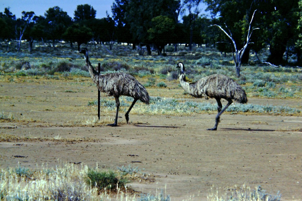
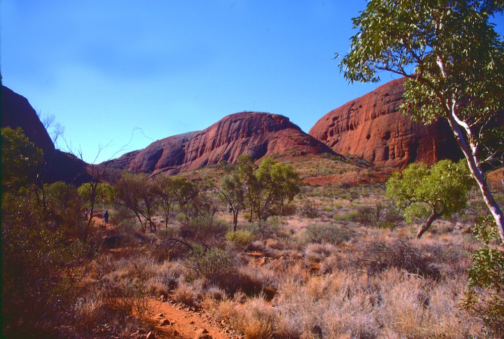
Mrs. Todd and her Roadrunners are looking at Outback Australia. This is a post about an Outback journey I organised for parents and children from a school back in 1985. It's hard to believe those students would now be about 40 years old.
In this post, some video clips I had taken back in 1985 as my group travelled to Uluru and back have been shared. They have been converted from VHS tapes to digital and are being shared for the first time.
The Australian Outback
I don't know exactly where The Outback is said to start but I've always understood it to be the more isolated, arid (desert-like) areas across the centre of Australia. Most Australians live in coastal areas although there are larger communities in some Outback areas including traditional land owners, miners and graziers (cattle ranchers).
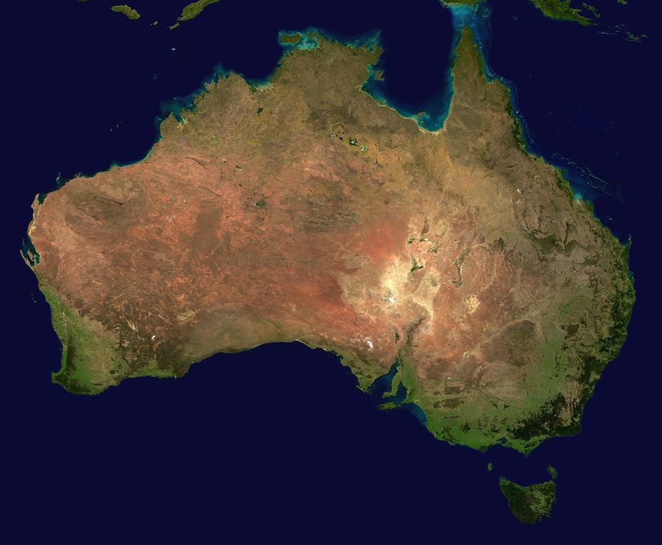
Let's look at a satellite photo of Australia Wikimedia lists as NASA sourced and in the public domain...
This image was sourced through Wikimedia Commons where it has bee sourced from NASA and is listed in the public domain. http://commons.wikimedia.org/wiki/File:Australia_satellite_plane.jpg
If you look at this photo you can see green areas are mostly coastal whereas from the west (left on the photo) to most of the way east you see reds, browns and even white. The white areas, especially the very white areas are not snow. They tend to be salt lakes and high salt areas only filling with water when there are very heavy rains in Queensland. Once the water reaches the lakes, it has nowhere to go as the lakes lie below sea level. The water evaporates and leaves the salt behind.
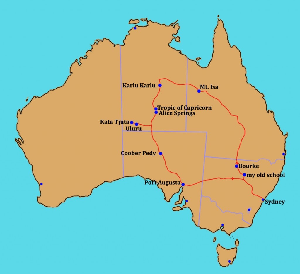
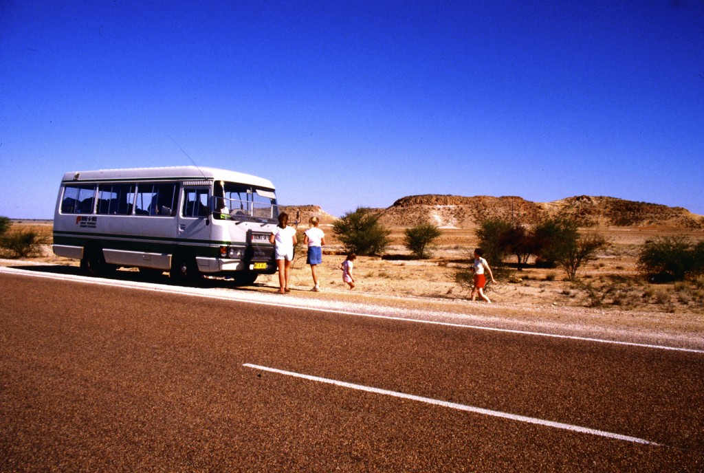
Let's look at the journey my group took back in 1985. I was the tour organiser and minibus driver on our two week, 7000+km (4350+mi) journey into The Outback and back .
Schools and students have permission to use this graphic for non-commercial, educational purposes.
We started out in Sydney, the capital of the state on New South Wales and headed west then turned north to spend our first night in an isolated school where I had worked in the early 80s.
The school, Marra Creek Public School, is about 670km (415mi) from Sydney and lies 100km (62mi) from the nearest town of Nyngan. It served children from local sheep and cattle properties. I stayed at a neighbouring shearer's house about 20km (13mi) from the school.
Schools and students have permission to use this graphic for non-commercial, educational purposes.
Was the school in The Outback? It was isolated, used water from tanks, had a phone where you had to talk to an operator to be connected, and only sometimes could pick up one television station if the conditions were good. I sometimes had to chase emus and kangaroos or even wild pigs out of the playground.
Schools and students have permission to use this graphic for non-commercial, educational purposes.
A video clip of emus in an animal sanctuary close to my home.
And some kangaroos from the same sanctuary.
When I first started there we had been in drought and the water tanks were low, temperatures at times reached 47C (116F). With rains, the clay pans turned green with grass and roads became muddy. We didn't have snow days but we did have mud days when half of the students couldn't make it along the dirt roads. We didn't build mud men. Snow seems to work better and is cleaner.
Heading across country, we visited the town of Bourke most would consider an outback town. It lies along the Darling River, a river sometimes drying out if rains don't fall in Queensland and can also flood when heavy rainfall comes. On our trip, rainfall in the outback had been unusually good but still low compared to coastal.
Schools and students have permission to use this graphic for non-commercial, educational purposes.
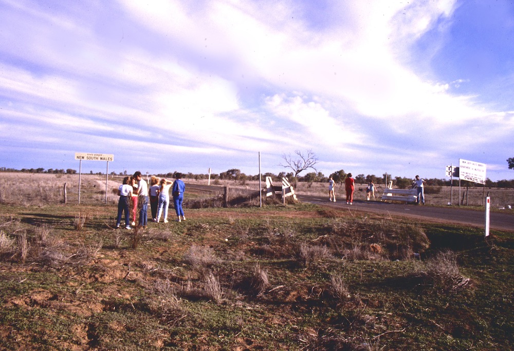
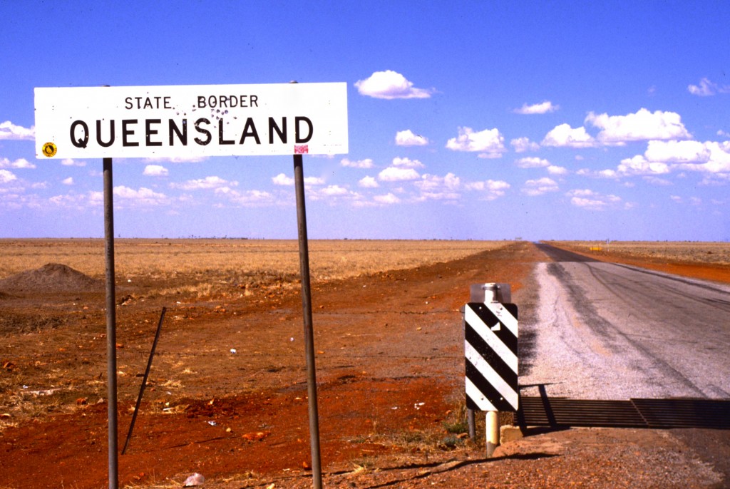
Not too far north of Bourke, we crossed into the state of Queensland. You can see in the photo below just how flat and semi-arid (almost desert) much of inland Australia can be.
Schools and students have permission to use this graphic for non-commercial, educational purposes.
Heading north, we were heading towards the town of Longreach. The landscape had dried out.
Schools and students have permission to use this graphic for non-commercial, educational purposes.
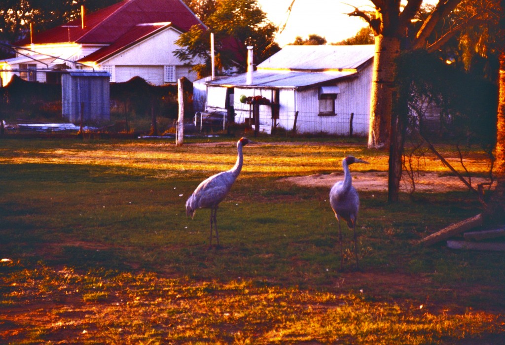
Stopping for the night, we were entertained by brolgas, the only cranes native to Australia. While at Marra Creek Public School, I had watched brolgas "dancing" their mating dance as they made jumps into the air.
Schools and students have permission to use this graphic for non-commercial, educational purposes.
The video clip below isn't one of mine but shows the dance of the brolgas.
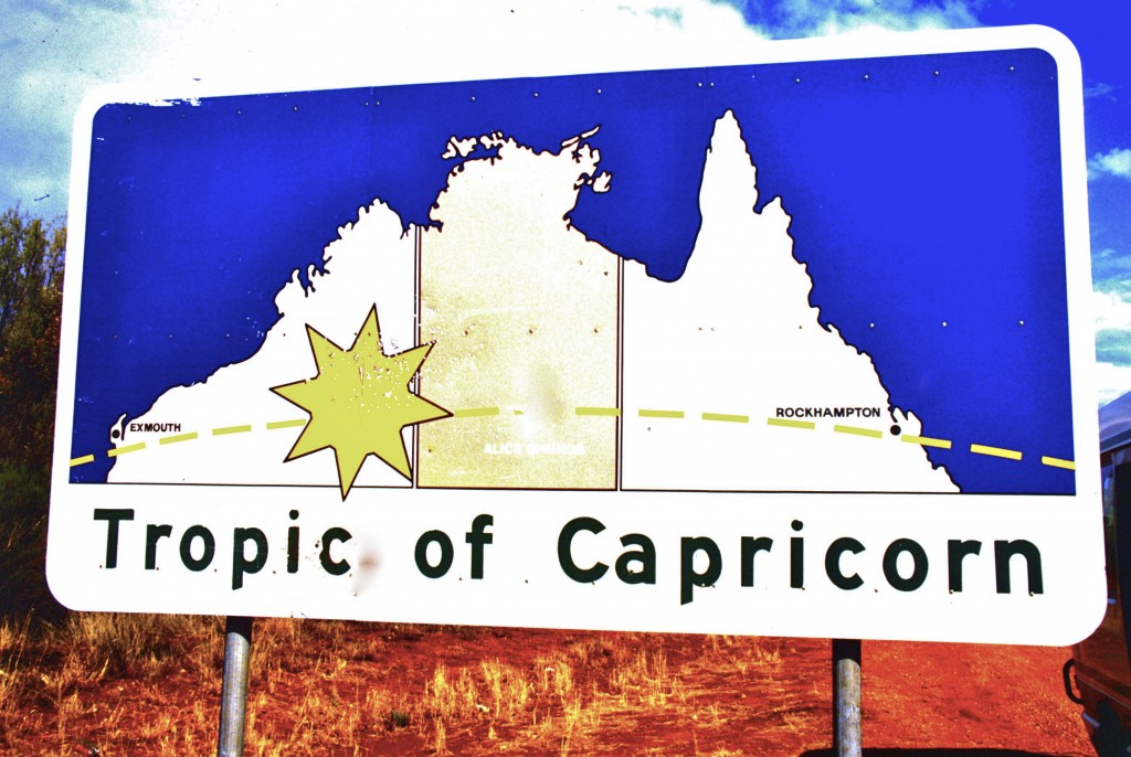
Just north of Longreach, we crossed the Tropic of Capricorn. This means we were now in the tropical region of the world.
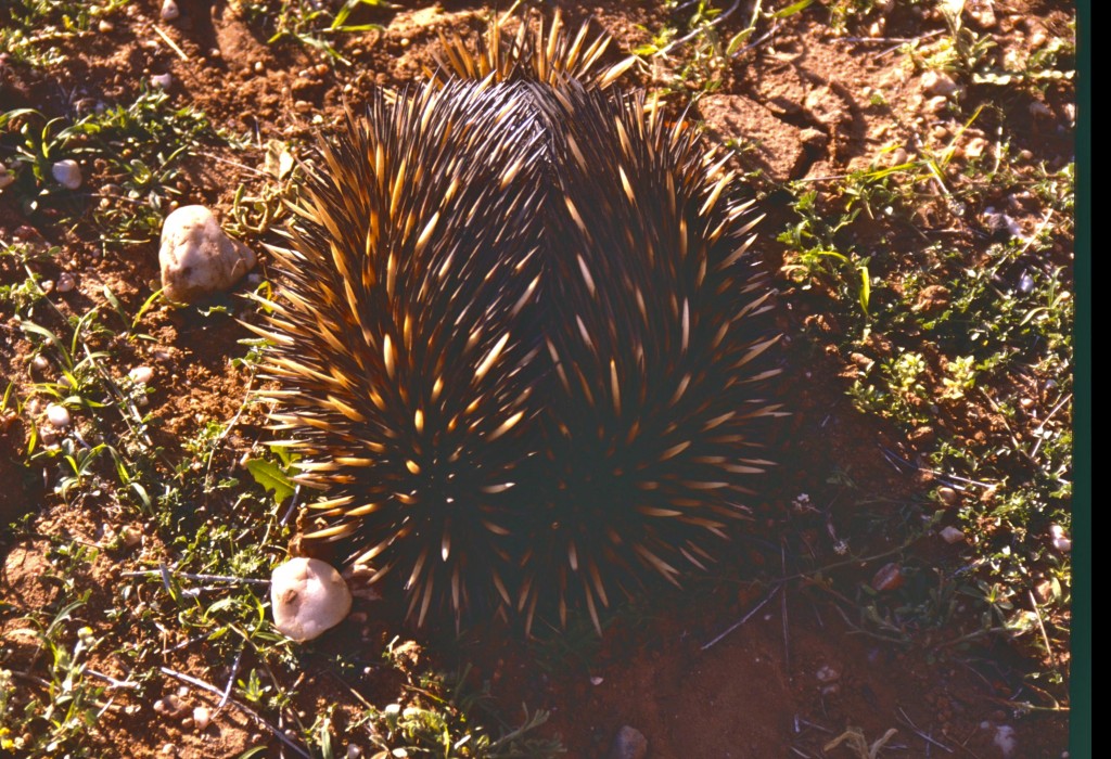
Near Longreach we saw an echidna on the side of the road. Echidnas and the platypus are the world's only living mammals that lay eggs but, as they are mammals, the mothers can give milk to their young. Echidnas are also found around my town and have sometimes visited my garden in search of ants.
Schools and students have permission to use this graphic for non-commercial, educational purposes.
Below is a video of an echidna taken at an animal sanctuary near my home.
Our next major settlement was Mount Isa (pictured below), a mining town in western Queensland. Lead, silver, copper and zinc are mined in the Mount Isa area.
Schools and students have permission to use this graphic for non-commercial, educational purposes.
You can easily see the red of the soil, a soil colour so common in The Outback.
From Mt. Isa, we head west to the border with Northern Territory. The photo below was taken standing in the state of Northern Territory looking into Queensland.
Schools and students have permission to use this graphic for non-commercial, educational purposes.
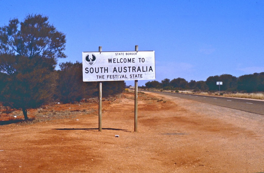
Reaching the Stuart Highway, a highway running from Adelaide, the capital of the state of South Australia, in the south to Darwin, Northern Territory's capital, in the north, we took a left turn because we had reached as far north as we were going on this journey.
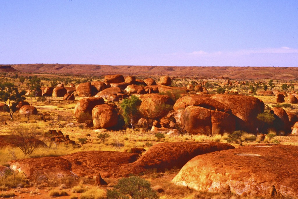
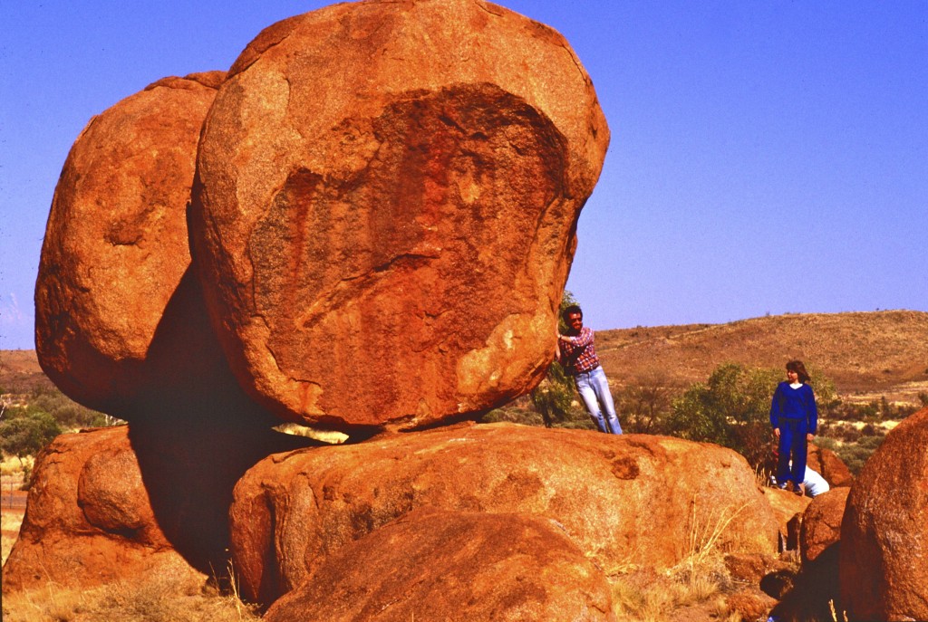
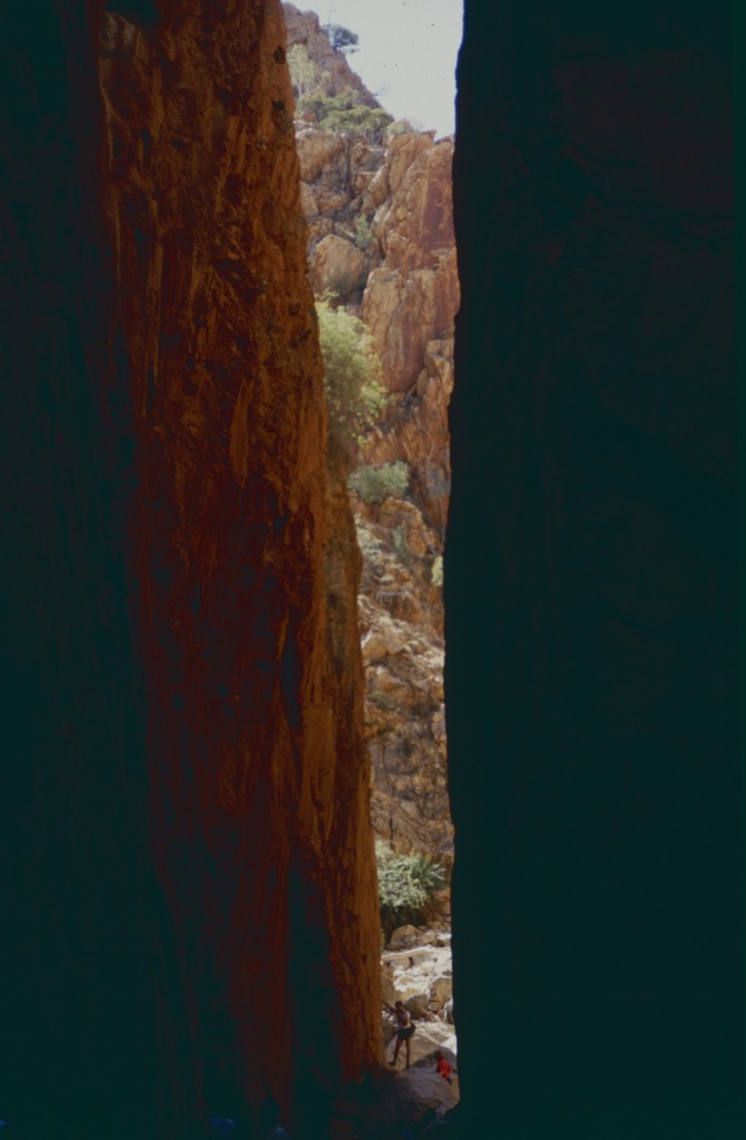
Passing through the town of Tennant Creek, our next major attraction was Karlu Karlu (known also as the Devil's Marbles) 105km (65mi) south of Tennant Creek. Here are some photos taken at Karlu Karlu.
Schools and students have permission to use this graphic for non-commercial, educational purposes.Schools and students have permission to use this graphic for non-commercial, educational purposes.
That's not me pretending to hold up the rock.
The video clip below was taken on the 1985 trip and has been converted to digital and shared for the first time.
Karlu Karlu is a sacred site to the Alyawarre (Aboriginal) whose country includes the site. It's also sacred to the Kaytetye, Warumungu and Warlpiri people. There are a number of traditional Dreaming stories for the Karlu Karlu area but only a few are able to be shared with uninitiated people such as us.
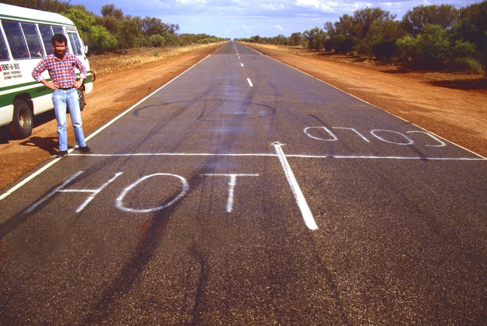
From Karlu Karlu, we continued south towards Alice Springs. As we travelled, we again crossed the Tropic of Capricorn, this time heading out of the tropics. Someone with a sense of humour had painted words on the road (not us).
Schools and students have permission to use this graphic for non-commercial, educational purposes.Schools and students have permission to use this graphic for non-commercial, educational purposes.
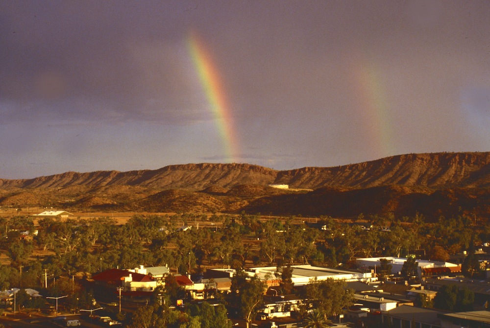
Alice Springs is the largest town in Central Australia and the third largest in Northern Territory. Central Australia is only a name for the area and is not a state. To the local people, the Arrernte, the Alice Springs area is known as Mparntwe.
On our visit, we managed to see a rare rainbow over Alice Springs.
Schools and students have permission to use this graphic for non-commercial, educational purposes.
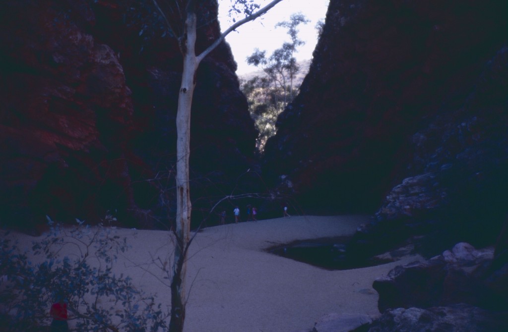
Alice Springs lies within the MacDonnell Ranges. There are so many beautiful places to visit in this arid area. Here are just two...
Standley Chasm
Schools and students have permission to use this graphic for non-commercial, educational purposes.
The video clip of Standley Chasm below was taken on the 1985 trip and has been converted to digital and shared for the first time.
Simpsons Gap (it was late in the day)
Schools and students have permission to use this graphic for non-commercial, educational purposes.
The video clip of Simpsons Gap below was taken on the 1985 trip and has been converted to digital and shared for the first time.
The video clip of black-footed rock wallabies below was taken on the 1985 trip and has been converted to digital and shared for the first time. The rock wallabies were our companions as we explored Simpsons Gap.
After leaving Alice Springs, we took time for a camel ride. Camels aren't native to Australia but were brought here by Afghan camel herders in the 1800s. Before roads and railways, all supplies had to be brought in by camel trains. When road and rail arrived, many camels were released into the wild. Australia now is the country with the largest number of wild camels in the world and at times exports camels back to the Middle East.
Schools and students have permission to use this graphic for non-commercial, educational purposes.
The video clip of camel riding below was taken on the 1985 trip and has been converted to digital and shared for the first time.
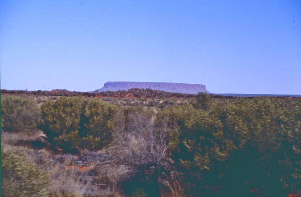
We were heading to Uluru and Kata Tjuta. Along the arid way, we saw Mount Conner standing high above the desert.
Schools and students have permission to use this graphic for non-commercial, educational purposes.
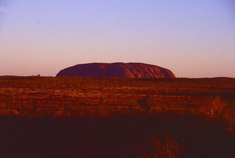
Tourists to Central Australia shouldn't miss a chance to see Uluru and Kata Tjuta. Here are some photos I had taken.
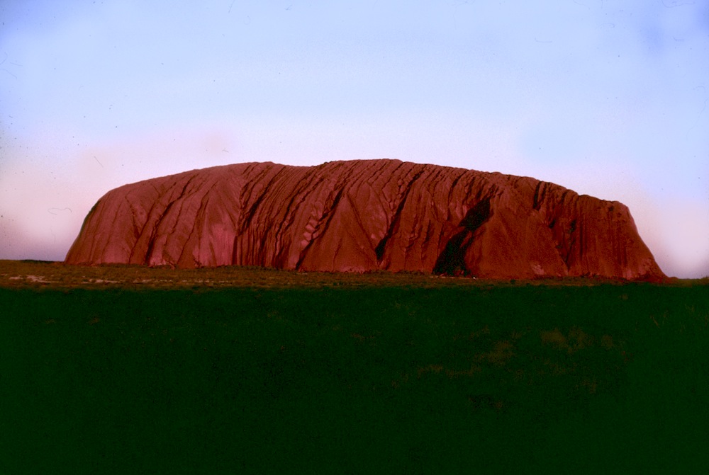
Uluru (aka Ayers Rock) at sunset
Schools and students have permission to use this graphic for non-commercial, educational purposes.
Uluru (aka Ayers Rock) at sunset
Schools and students have permission to use this graphic for non-commercial, educational purposes.
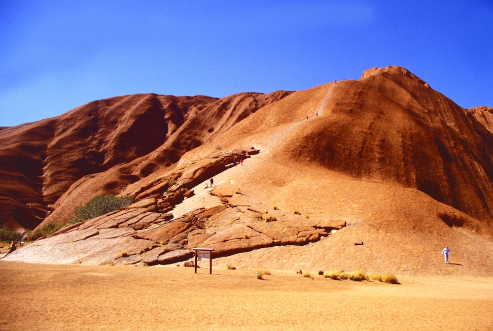
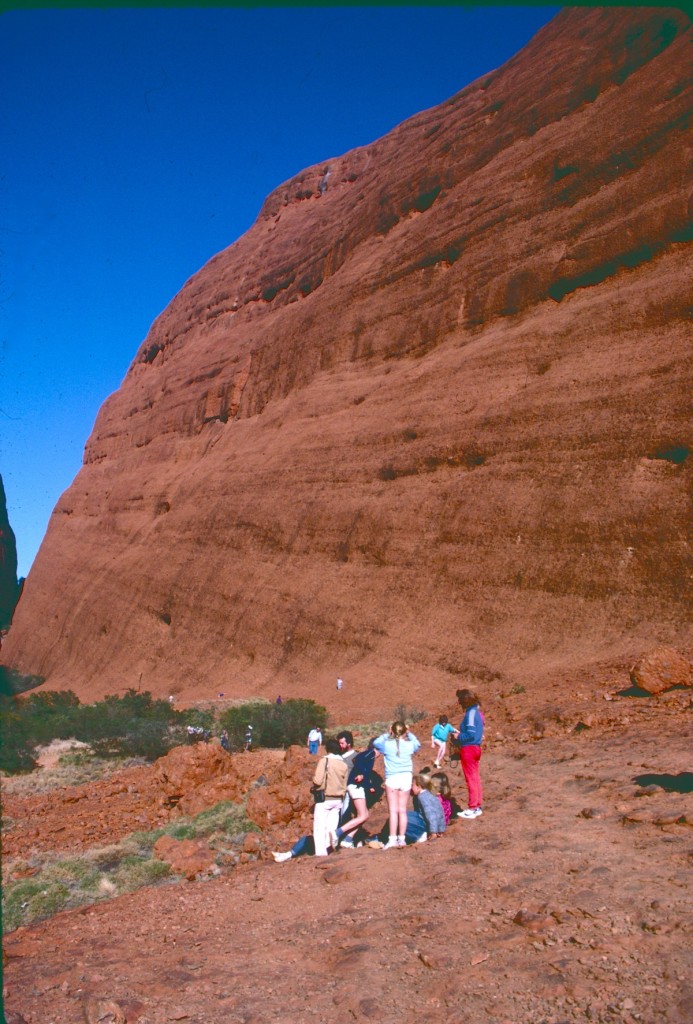
Uluru (aka Ayers Rock) up close
You can get an idea of its size by looking at the people climbing it.
Schools and students have permission to use this graphic for non-commercial, educational purposes.
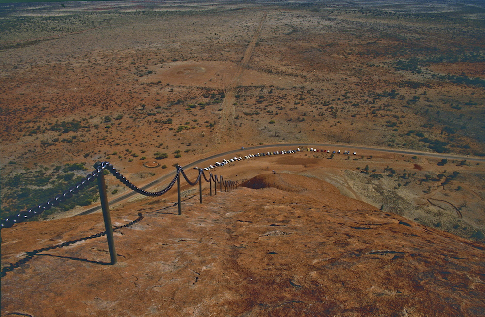
And a view from almost the top of Uluru
Schools and students have permission to use this graphic for non-commercial, educational purposes.
Since my visit 30 years ago, visitors have become much more aware of the importance of Uluru to the local people. While they don't stop visitors climbing the rock, many visitors now choose not to climb in respect for the beliefs of the local people.
The video clip of an Uluru sunset below was taken on the 1985 trip and has been converted to digital and shared for the first time. It is running at 20x normal speed.
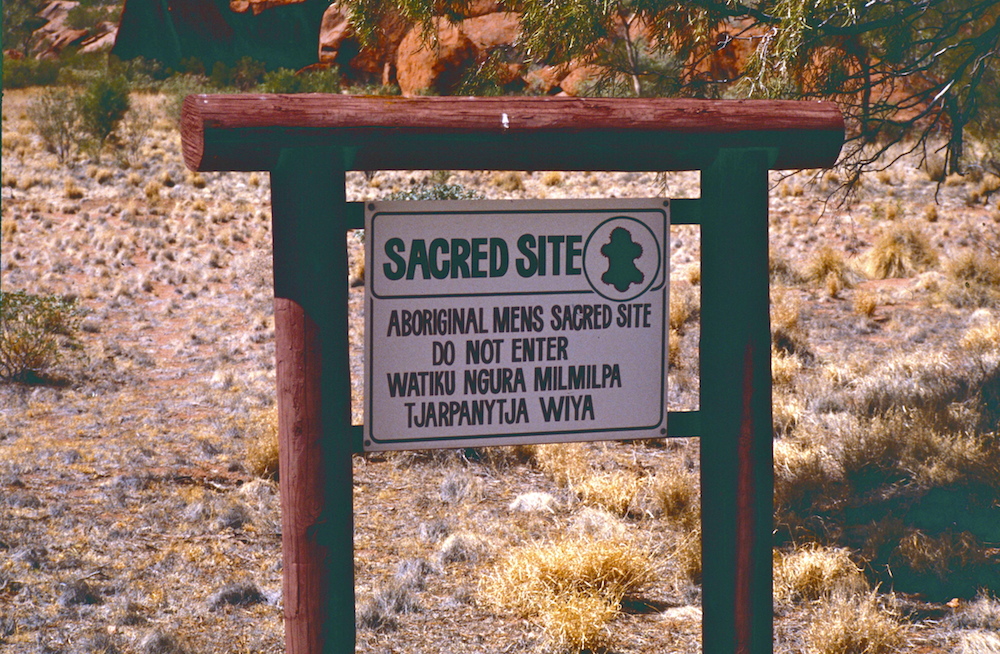
Around the base of Uluru, there are many sacred sites we are asked to respect. Some are sacred men's sites and some sacred women's sites.
Schools and students have permission to use this graphic for non-commercial, educational purposes.
However, there are sites visitors can see. Here is a photo taken at one such site, Mutitjula (Maggie Springs). You can see some of the rock paintings.
Schools and students have permission to use this graphic for non-commercial, educational purposes.
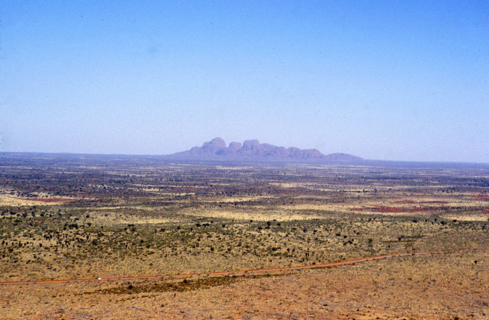
From Uluru, it is possible to see the distant Kata Tjuta rising from the desert plain.
Schools and students have permission to use this graphic for non-commercial, educational purposes.
Back in our mini-bus, we headed along the dirt road to Kata Tjuta.
Schools and students have permission to use this graphic for non-commercial, educational purposes.
Schools and students have permission to use this graphic for non-commercial, educational purposes.
On leaving Uluru and Kata Tjuta, we rejoined the Stuart Highway and again headed south crossing the state border into South Australia.
Schools and students have permission to use this graphic for non-commercial, educational purposes.
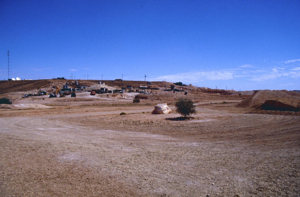
Our next stop would be Coober Pedy, famous for its opal mined in the area. Because of the high temperatures on summer days, some homes in Coober Pedy have been built underground.
Schools and students have permission to use this graphic for non-commercial, educational purposes.
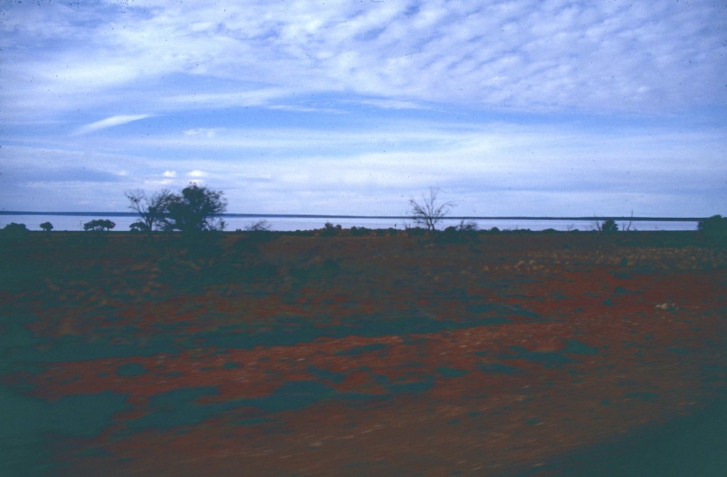
Heading further south, we started to see salt lakes near the road. As they are lower than the distant sea, water entering can't flow out. The water evaporates and leaves the salt behind. You can see a late afternoon photo of a salt lake.
Schools and students have permission to use this graphic for non-commercial, educational purposes.
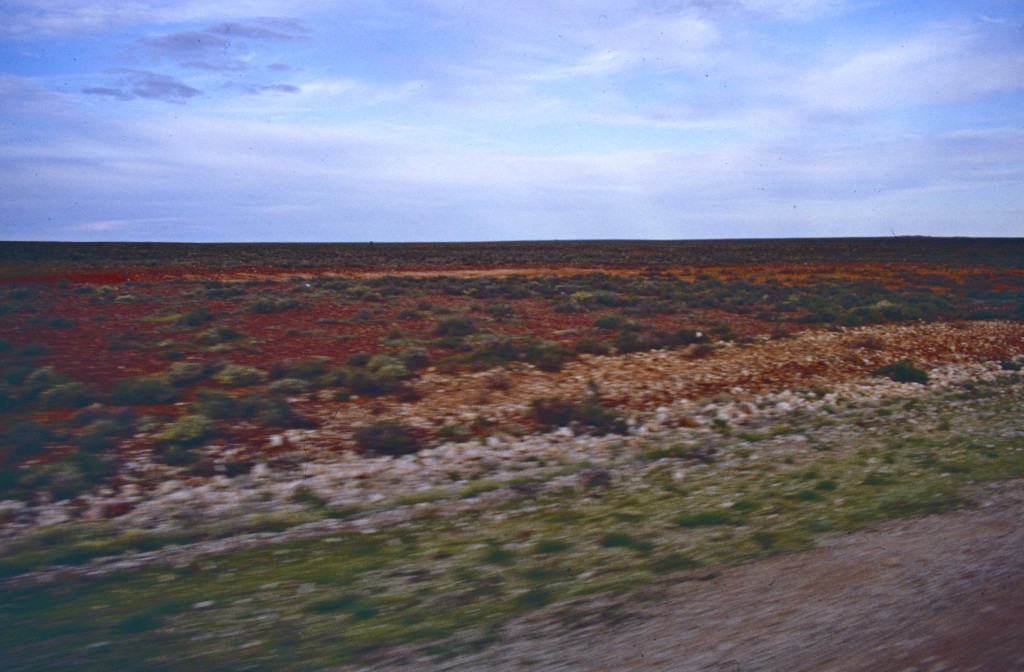
There were many kilometres of flat roads as we continued south.
Schools and students have permission to use this graphic for non-commercial, educational purposes.
On reaching Port Augusta in South Australia, we headed east and back to Sydney. We had travelled over 7000+km (4350+mi) in our journey through The Outback.
Eevie left a reply to a comment I left on her class blog. She shared history can be hard to understand. I suggested using our imagination to picture events in history. I also suggested drawings and pictures can help us better understand.
At present I am involved in the long task of scanning 35mm slides, negatives and photos into my computer. I thought I would share some of my "windows into history" and what I know about them. Let's go back in history...
The Year: 1998
Schools and students have permission to use this graphic for non-commercial, educational purposes.
We are looking south along ANZAC Parade. I am on the stairs leading to the Australian Way Memorial. In the distance we see the white Old Parliament House and behind it is the new Parliament House. In 1998, John Howard was Prime Minister (1996-2007). The scene today is still much the same but what happens if we look at an older photo from 1984, fifteen years earlier...
Schools and students have permission to use this graphic for non-commercial, educational purposes.
The scene looks almost the same but, if you look carefully, you can see the new Parliament House is being built. The photos show me the new Parliament House was being built in the 1980s but was open by the 1990s. When Australia became a nation back in 1901, Canberra was sheep grazing country. Can you imagine the above photos without the lake, roads and buildings when sheep were grazing on the grass?
In 1984, Bob Hawke was Prime Minister (1983-1991). It was during the time of Bob Hawke most Australians celebrated the bicentenary (200th) anniversary of the first settlement of Europeans in Australia in Sydney. Part of the celebrations involved ships from around the world re-enacting the First Fleet journey with convicts to Australia.
The year: 1987. Prime Minister Bob Hawke visited the First Fleet ships in Hobart, Tasmania.
Schools and students have permission to use this graphic for non-commercial, educational purposes.
In January, 1988, the First Fleet re-enactment fleet arrived in Sydney Harbour and was greeted by thousands of people lining the harbour's shores for Australia Day (January 26).
Schools and students have permission to use this graphic for non-commercial, educational purposes.
Can you imagine what it might have been like for the convicts and soldiers arriving on the First Fleet back in 1788?
How do you think the Aboriginal people living around the harbour back then might have felt seeing the ships arrive?
You have probably heard about the voyages of Captain Cook and how, back in 1770, he was the first European known to have sailed along the east coast of Australia. There were drawings back then but cameras hadn't been invented. Look at the photo below. I would love to be able to say I could travel back in time to see the Endeavour sailing along our coast in 1770 but this photo was taken in 2012. It is a replica of Cook's Endeavour. Young people today can experience being part of the crew aboard this sailing ship. As well as photos and drawings, there are places we can visit to experience history. Perhaps you have visited Ballarat's Sovereign Hill? I will soon be scanning some slides taken there in 1984.
Schools and students have permission to use this graphic for non-commercial, educational purposes.
What do you think it was like to be a sailor on the Endeavour? If you are interested, the link below will take you to another of my blogs where you can see more photos and some video of the Endeavour replica when it visited Twofold Bay at Eden in N.S.W. in May, 2012.
What was Sydney like early in its history? There weren't any cameras to take photos back when the First Fleet arrived in 1788 but there were drawings made of the early settlement. Using these drawings, the early 1980s saw the building of Old Sydney Town set in the early 1800s. Children could visit Old Sydney Town to see what Sydney was like nearly 200 years ago. Old Sydney Town was living history...
Schools and students have permission to use this graphic for non-commercial, educational purposes.
Can you imagine what it might have been like to be a child living in Sydney back in the early 1800s?
What about the Aboriginal people who lived around the new settlement way back then? Much of the culture of the original people of the Sydney region has been lost but there are still reminders of their history. In 1991, I visited an area of Sydney's Royal National Park in order to photograph rock carvings left by the original people of Sydney. They will eventually be lost to erosion but my photos have kept a window to the past open. Can you see what animal is shown in the carving?
Schools and students have permission to use this graphic for non-commercial, educational purposes.
Did you guess a stingray?
Photos can also give us more direct glimpses into the past. The photo below was taken in 1987 and shows the gravestone of Mary Agnes Hurley who died in 1871 at Hill End, N.S.W. when she was 25 years old. Do you think she might have been married and have had children?
Schools and students have permission to use this graphic for non-commercial, educational purposes.
Old photos and drawings can let us better know people from the past. Let's go back to 1940 for the photo below. It shows a signaller soldier, my father, when he was 21. With the outbreak of World War II, he joined the army and was sent to Singapore. With the fall of Singapore to the Japanese in 1942, he spent the remainder of the war as a prisoner of war. Without photos, I would never have seen him as a young man.
Schools and students have permission to use this graphic for non-commercial, educational purposes.
Going back to 1915 and the First World War, I have the photo below...
Schools and students have permission to use this graphic for non-commercial, educational purposes.
I never knew or met this young man from the past yet he is my Great Uncle Ernie (my father's uncle). He went to fight in France and never returned.
History can seem hard to understand but using our imaginations and what we can learn by reading, visiting historical sites, seeing replicas or dioramas, watching videos or looking at photos and graphics from the past, history can become alive.
After posting the previous comment for you, I realised I hadn't commented on a reply you left for me on your blog in October. I intend keeping it shorter as I am running out of time and will filming about four hours after posting this. Because I wanted to share some photos, I needed to create another post. Two for one class in a day is probably a record.
Does Australia celebrate Thanksgiving?
Thanksgiving isn’t celebrated in Australia. Rather than free settlers, the first Europeans sent to Australia were convicts and guards from England. They arrived in 1788. Bringing northern hemisphere ideas to the southern hemisphere and not having farmers meant early attempts at crops failed. People were at first starving as rations were short. A spring planting in England might be March but planting in March here is autumn (fall). One of my ancestors arrived as a convict aboard the second fleet in 1789. Life was starting to get easier but I don’t think the convicts felt like giving thanks for being so far from home.
Do you know if Ayers Rock HAS iron in it? We would LOVE to know!
Ayers Rock is sandstone but the redness is iron oxide (rust). The area around Uluru is often known as The Red Centre. You can see the contrasting colours of red soil and blue sky in some of my photos.
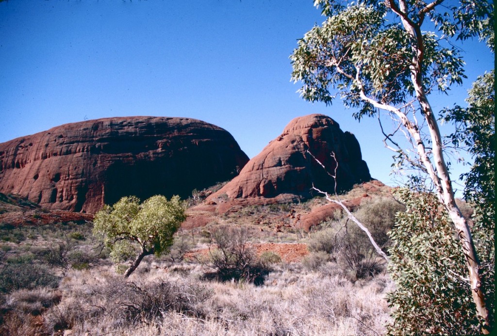
Kata Tjuta
Schools and students have permission to use this graphic for non-commercial, educational purposes.
The lace monitor is even taller than Mrs. Renton is!
You'll find information about monitor lizards in today's earlier post for you at...
We wondered if the kangaroos on the golf course were playing golf.
The kangaroos on the golf course aren’t interested in golf unless a ball hits them but birds have been known to swoop down and take balls. The kangaroos like the green grass and lying in the sun.
Do you have pictures of Sapphire?
Schools and students have permission to use this graphic for non-commercial, educational purposes.Schools and students have permission to use this graphic for non-commercial, educational purposes.
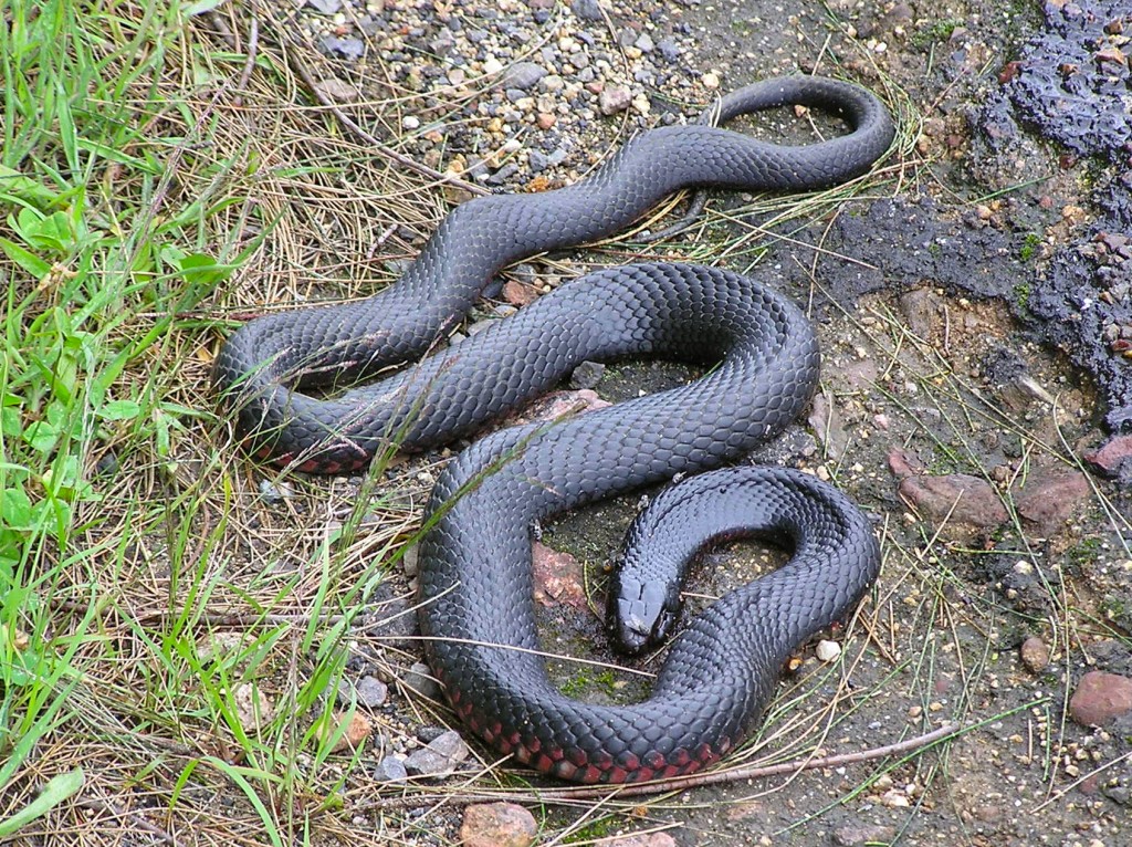
It makes us wonder if you have ever been bitten by a snake.
I have seen many poisonous snakes including a couple on the playground of two of my schools. They were both red-bellied black snakes and would rather escape than try to bite someone.
I did once stand on the tail of a brown snake hiding under a branch. I saw it move and stepped back to let it escape. They can be aggressive but the branch it was under prevented it from seeing me. I have also seen another aggressive snake, the tiger snake, on a track in front of me so I walked around it. When hiking, I wear heavy steel capped boots and try to walk where I can see the ground as an extra precaution. Walking in thick, long grass in warmer months isn't a good idea.
I find snakes better left alone in the wild but I have held some pythons in animal parks over the years. They are cool to the touch and very interesting. Many people are surprised they aren’t slimy.
Red-bellied Black Snake
Schools and students have permission to use this graphic for non-commercial, educational purposes.
We wondered if “fortnight” was a week, or overnight.
Fortnight is a word still used in Australia and yes it is fourteen nights or two weeks. Many people in the world speak English but there are differences. Much of our Australian English is like England’s English but there are also some similarities with North American English.
A student was learning about Australia and shared some facts and questions. Enjoying reading what was shared, I thought I would provide some information. To see the original Google document...
Here is a summary of information based on your Google document. If you scroll down to "About Australia" on this post, you can read some of the information used to find answers and facts.
There are six Australian states.
The first known Europeans came to Australia arrived in 1606 although the Chinese may have come in the 1400s. People from Indonesia and may have arrived much earlier and the Aboriginal people first came here as much as 60,000 years ago.
Western Australia is our largest state.
There were many language groups in Aboriginal Australia, each with their own cultures. They didn't have tribes like Native Americans.
Australia is the largest island and smallest continent. It is the only continent to be one nation.
Australia has a number of states and territories.
Australia borders the Indian, Pacific and Southern Oceans.
Australia is an island and not landlocked. Landlocked means no access to the sea.
Australia'c capital city is Canberra in the Australian Capital Territory. Each state and territory has its own state/territory capital.
Your questions.
- What are these “parts” called? - The main part of Australia has six states (Western Australia, South Australia, Queensland, New South Wales, Victoria and Tasmania)and two territories (Northern Territory and Australian Capital Territory).
- Why are they so big? - Our states are large because of the arid and semi-arid areas, a much smaller population than the U.S.A. and finding most people live along or near the coast.
- How did they name them? - Northern Territory, Western Australia and South Australia were given their names because of their location. Victoria and Queensland were named in honour of Queen Victoria. Tasmania gained its name from the first European explorer to reach it Abel Tasman. New South Wales was named by Captain Cook. It's said the coast reminded him of parts of Wales in the United Kingdom.
- Who decided to split this country? - The country wasn't really split. Areas gained their names as new colonies were established.
- Who did this? - Each state had a governor representing the king or queen and a government. In a way, each state had been its own country and could set laws.
- How did this happen? - With all the states agreeing after many meetings of state leaders, Australian became a commonwealth and nation in 1901.
- Is it because a historical feature that slowly split them? - The historical feature was colonisation. With large distance between colones, it was better for each colony to control its own area while officially being governed by the king or queen through a governor.
- Was it because of a war? - Australia became a nation by agreement and not war. The English crown also approved Australia becoming a nation.
- When did this happen? - The first British colony was founded in 1788 in an area of Sydney near the now famous Sydney Harbour Bridge. The second colony was established was Van Diemans Land (later Tasmania).
- Why did it happen? - When there was only one colony, the east of Australia and New Zealand were all in the colony of New South Wales. As new colonies were formed, new borders were drawn up and New Zealand separated from New South Wales. Federation in 1901 came about because the states decided they should all be part of one nation.
- When was this discovered? - The borders in Australia were made using rivers or latitude and longitude readings. The changes all came about over time so there was no great discovery.
Read on to see more information on Australia plus links to other blogs.
About Australia
Here is a map of Australia I have drawn...
Schools and students have permission to use this graphic for non-commercial, educational purposes.
The main part of Australia has six states (Western Australia, South Australia, Queensland, New South Wales, Victoria and Tasmania)and two territories (Northern Territory and Australian Capital Territory). It also has jurisdiction over Cocos (Keeling) Islands, Christmas Island and the Ashmore and Cartier Islands in the Indian Ocean and the Heard and McDonald Islands in the Southern Ocean.
The map also shows the capital cities of each state or territory. Canberra is our national capital.
Australia is said to be the world's smallest continent and the world's largest island. Any land mass larger is a continent and any small an island. It's the only continent that is one country. Much of it is arid to semi-arid (desert to very dry areas). You can see on the map cities tend to be near the coast or the wetter eastern coast.
Another student was interested in the "outback" and wanted to know if I'd been there. If you're interested, click the link below and you will see information about a 1985 trip through the Australia's centre.
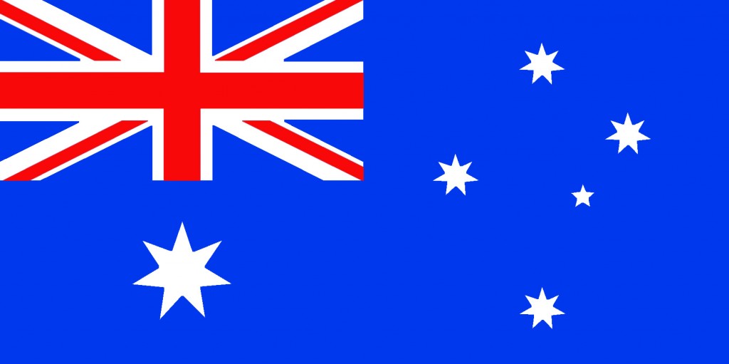
The Australian flag has three major features on a blue background. In the top left hand corner, there is the Union Jack as in the Union Flag of the United Kingdom. The large, seven pointed star under the Union Jack is known as the Commonwealth Star. Six points are for the six states and the seventh is for Australian territories. The five stars at the right represent the Southern Cross (Crux to astronomers). It's always in our sky.
The First Australians
Firstly, it's thought the first Aboriginal people came to Australia from Asia up to 60,000 years ago. At that time the world was cooler and sea levels lower because a polar ice. The islands of Indonesia would have seemed closer because the low sea levels meant coasts were further out. It was possible to walk across dry land from New Guinea to Australia and from the state of Victoria to Tasmania.
Much of Australia was forested with lakes. There is evidence, particularly around the dried lake bed known as Lake Mungo, of thriving people living along its shores. As climate warmed, the land links to New Guinea and Tasmania were covered with water as they are today. Australia's centre started to dry. Forests and lakes disappeared and the Aboriginal people adapted their habits to live in the arid and semi-arid conditions.
Schools and students have permission to use this graphic for non-commercial, educational purposes.
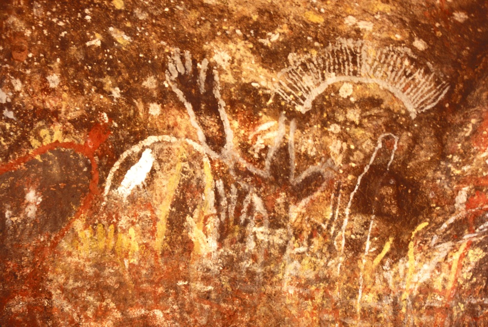
This photo is of Aboriginal art on Uluru (Ayers Rock).
Rather than one tribe, there were many language groups. The Aboriginal people didn't really have tribal groups as the Native Americans have. My area of Australia is Yuin land. There were many language groups and different beliefs across Australia. Each were rich in culture and belief. Click on this link to see the Aboriginal Australia map.
To find out more about Aboriginal Australia, here is a link to a post I wrote for a class looking at Australia's original people...
This is one side of Australia's dollar note showing Aboriginal designs. It has now been replaced by a coin.
Chinese and European "Discovery"
I've always thought it a little strange when people speak of who discovered Australia. Surely that claim could only go to the first Aboriginal people coming to Australia fifty to sixty thousand years back. Who else "discovered"Australia?
There is apparently some evidence Chinese explorers as early as the 1400s. Between 1405 and 1453, a Chinese admiral sailed a huge fleet of junks south to Timor and so could well have visited Australia.
Here are some of the first known Europeans to make it to Australia were...
1606 William Jansz on the "Duyfken" saw the coastline of northern Australia
1616 Dirk Hartog on the "Eendracht" landed on Western Australia's coast
1642-1643 Abel Tasman reaches Van Dieman's Land (Tasmania)
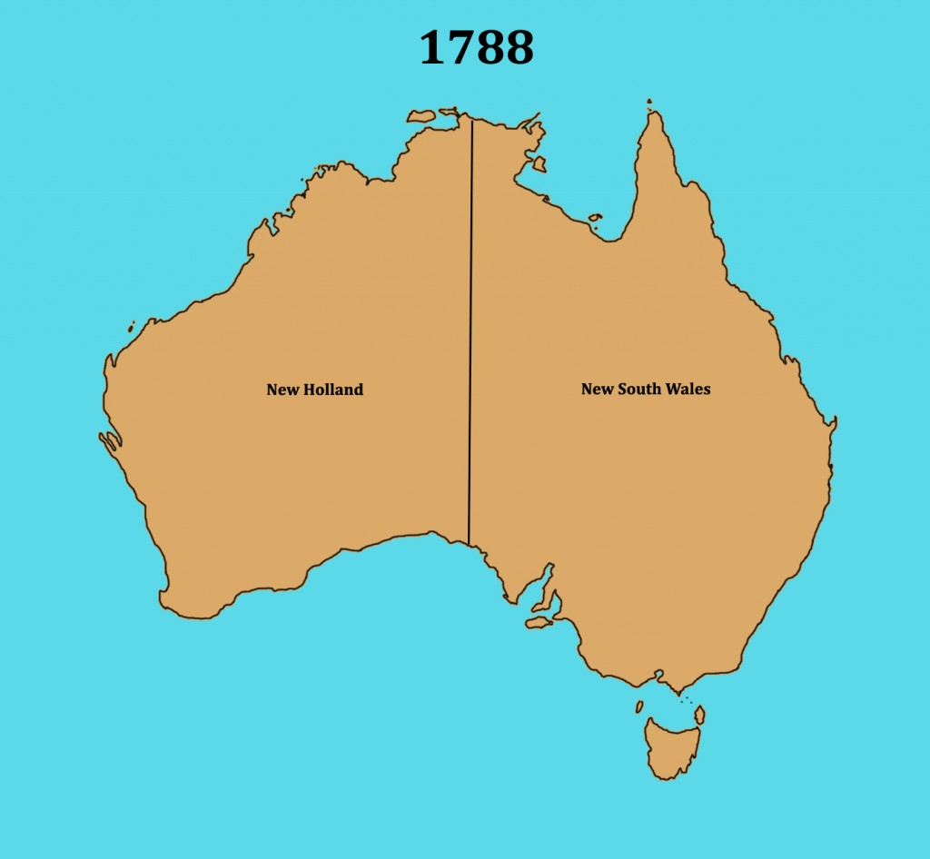
You might have noticed the names are Dutch. The western area of Australia became known as "Hollandia Nova" (New Holland).
The first known Englishman known to have reached Australia was WIlliam Dampier in 1688. He also only reached the west coast of Australia. It wasn't until 1770 before the first European sailed along Australia's east coast.
This graphic was sourced through Wikimedia Commons and is listed as in the public domain in U.S.A..
Captain James Cook's 1769/1770 Voyage
Below is a photo of the H.M.B. Endeavour taken at Twofold Bay, in 2012. It is a replica of James Cook's H.M.S. Endeavour and visited Twofold Bay near my home. If you look at the background, little would have changed since Cook's voyage nearly 250 years ago.
Schools and students have permission to use this graphic for non-commercial, educational purposes.
In 1769, Captain James Cook set sail from England on the "Endeavour". His task was to take scientists to see the transit of Venus from Tahiti in the Pacific Ocean. His other task was to solve a mystery. Many had thought there must be an undiscovered continent south to balance the world's countries up north. Some maps named it Terra Australis (Southern Land). Cook was given the task of once and for all time showing no such land exists.
After heading south from Tahiti, he came to New Zealand in 1769. He mapped the islands before heading west. He first sighted Australia in 1770 at a place named Point Hicks a few hundred kilometres to the south of my home. He made maps of the land as he sailed north, naming it New South Wales.
New South Wales and a British Colony
At this point in Australia's history, the history of the United States overlaps ours. I'm certain you know the importance of the year 1776 for the U.S.A.. When England lost its American colony, they were looking for another place. English prisons were overloaded with convicts and couldn't be sent to America. It was decided to send a small fleet of ships to the land described in Cook's voyage.
Schools and students have permission to use this graphic for non-commercial, educational purposes.
On January 26, 1788, the English flag was raised in the new colony of New South Wales. At this point, New Zealand was also part of New South Wales.
1825 - the border with New Holland had moved to where the Western Australia border now lies. Van Dieman's Land (Tasmania in 1856) became a separate colony.
1829 - New Holland becomes known as the Swan River Colony and Western Australia in 1832.
1840 - New Zealand is no longer part of New South Wales, and the colony of South Australia is formed although it isn't until 1860 when South Australia has the borders we see now.
1851 - The colony of Victoria is formed.
1859 - Queensland is formed as a colony.
1901 - The Commonwealth of Australia is formed by the member states and Australia becomes a nation and not a collection of colonies.
1911 - Federal Capital Territory (Australian Capital Territory in 1938) and Northern Territory are formed.
Each of Australia's states started out as a British colony with their own government, money and banks. With federation in 1901, the states had agreed to join as a commonwealth. There wasn't a war between our states. Our political system is based on that of the United Kingdom. We have a Prime Minister rather than a president and Queen Elizabeth II is recognised as our head of state with a governor-general her representative here in Australia.
Until 1984, Australians sang "God Save the Queen" at official events, the same national anthem as in the United Kingdom. In 1984, "Advance Australia Fair" became our official national anthem. Click on the title below to hear a choir of about 100 sing our national anthem.
Our states are large because of the arid and semi-arid areas, a much smaller population than the U.S.A. and finding most people live along or near the coast. The largest U.S. state by land is Alaska at 1,481,347 square kilometres. With Western Australia being 2,526,786 square kilometres and Queensland being 1,723,936 square kilometres. Alaska would only be the third largest if it were part of Australia.
The area of United States is about 1.3 times larger than Australia yet the U.S. population is nearly 14 times larger than Australia. We have much more space but few people live in much of Australia because of its harsh climate.
Schools and students have permission to use this graphic for non-commercial, educational purposes.
To see more links to Australian information as well as video clips of Australian animals, click the link below...
Official school events in my region normally start with an Acknowledgement of Country. It recognises the original owners of the land. Click the link below to hear one of my recordings.
This audio recording should not be used without my written permission.
The Australian Aboriginal Flag
The Australian Aboriginal Flag was designed by artist Harold Thomas and first flown at Victoria Square in Adelaide, South Australia, on National Aborigines Day, 12 July 1971.
Torres Strait Islander Flag
The Torres Strait Islander flag was designed by the late Bernard Namok as a symbol of unity and identity for Torres Strait Islanders.
In 1995, both of these flags became official flags of Australia.
In order to share some of the stories from the many peoples of Australia, below are a series of embedded You Tube videos sharing Dreaming stories. Where I can, I have added personal photos or drawings relating to the stories if students want to use them. At the end of this post you will find a video looking at indigenous tourism in Australia (52:26min).
Dreaming Stories
1. About Dreaming Stories (7:32 min)
This embedded You Tube clip is not my video.
This is a draft video for the Australian Museum for their Dreaming Stories. The performers are Gumaroy Newman, Eric Arthur Tamwoy and Norm Barsah. Video by Fintonn Mahony, Lisa Duff, Bronwyn Turnbull and Gina Thomson.
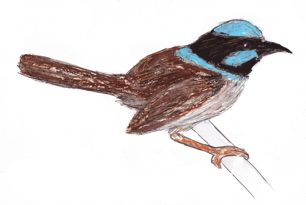
2. Aboriginal Dreaming story of Waatji Pulyeri (the Blue Wren or superb fairywren) (5:33 min)
This embedded You Tube clip is not my video.
Schools and students have permission to use this graphic for non-commercial, educational purposes.
These small wrens often visit my garden searching for insects. The drawing is of a male. Females and juveniles are plain brown.
Schools and students have permission to use this graphic for non-commercial, educational purposes.
Rainbow lorikeets are native to my area and regularly visit my garden.
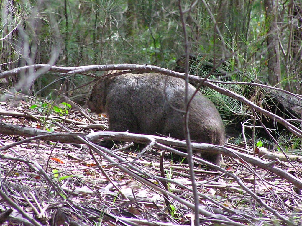
4. Mirram The Kangaroo and Warreen The Wombat (4:32 min)
This embedded You Tube clip is not my video.
Schools and students have permission to use this graphic for non-commercial, educational purposes.
A species of kangaroo common to my area is the eastern grey kangaroo.
Schools and students have permission to use this graphic for non-commercial, educational purposes.
Although mainly nocturnal, I found this wombat out during the day.
4. Girawu The Goanna (4:00 min)
This embedded You Tube clip is not my video.
Schools and students have permission to use this graphic for non-commercial, educational purposes.
One of our local goannas.
5. Biladurang The Platypus (2:58 min)
This embedded You Tube clip is not my video.
Schools and students have permission to use this graphic for non-commercial, educational purposes.
The platypus, a monotreme (egg laying) mammal, can be elusive. I have caught glimpses of them in mountain streams but don't have a photograph.
6. Tiddalick The Frog (2:43 min)
This embedded You Tube clip is not my video.
Schools and students have permission to use this graphic for non-commercial, educational purposes.
7. Wayambeh The Turtle (2:43 min)
This embedded You Tube clip is not my video.
Schools and students have permission to use this graphic for non-commercial, educational purposes.
Snapper turtle at a local animal sanctuary.
The Aboriginal People of Australia
Many people think there was one Aboriginal (native Australian) culture and one language but, before the coming of European colonists, there were many, many of those cultures now lost. One of the best sites I have seen comes from the Yolngu people of Ramingining in the northern part of Central Arnhem Land in Australia’s Northern Territory.
For one of their creation stories, click the link Twelve Canoes and wait for the site to load. The picture below will appear. Once loaded, click on the picture indicated by the arrow to see a creation story.
This graphic should not be copied.
I think you will find many interesting things on this site as well as one of their creation stories.
Olivia wrote a thank you post on her blog and asked if I would write an extended comment for her. I explained how I get ideas for extended comments...
There is something in a post that sparks the idea or I find I need to share pictures, video or sound but can’t in a normal comment section on someone’s blog.
See if you can give me an idea that will spark a post…
What are you interested in?
Have you ever been to or wanted to go to interesting places?
Have you seen something and wanted to know but aren’t sure how to find out?
Have I written something you found interesting but were curious about a part of the post?
In a reply to my comments, Olivia gave some answers to the above. While her answers were interesting, it was her questions at the end that gave me the idea for this post...
Why did you want to start blogging? Have you always lived in NSW? Do you ever feel like you would like to come and visit people from around the world?
Here are the answers to her questions...
Why did you want to start blogging?
I never really thought about blogging in early 2011. I had heard of it but not taken much notice. I was no longer teaching and was currently enjoying writing a children's novel I never bothered trying to have published. Seeing some links to blogs from teachers on Twitter, I saw students were making use of them to share ideas and work. Their teachers were writing posts about education. I decided to see what blogs were all about. To do this, I had to start a blog I called "Ross Mannell's General Education Blog". I wrote my first post in June, 2011. It was about teaching and education. Here is what it looked like...
This should not be copied, reproduced or used in any way without my written permission.
I found blogging interesting but have posted only 9 times to this blog in two years. Writing about educational and other matters didn't interest me as much as writing narratives.
What changed my mind and made blogging so important to me?
At first I visited some student blogs and left short comments for them. I found I enjoyed doing this and receiving replies. One blog I visited needed me to join the blog provider in order to comment. A new blog was born in late 2011.
I wrote a comment for a class in England. They were learning about volcanoes, an interest of mine. I offered to send them volcanic samples from New Zealand, Fiji/Samoa and Hawaii. In order to explain what was being sent, I needed to share photos. Comments sections didn't allow this so my newest blog was used.
The original blog I started in late 2011 had to be moved to another blog provider in 2012. This "Extended Comments for Students" blog and was started in late May, 2012. The volcano posts are still on this blog.
I didn't plan starting to blog for students. It just happened because I wanted to share with others. 🙂
Have you always lived in NSW?
Yes.
I was born in Sydney and grew up in Bankstown as had my father. I studied at Sydney University then Sydney Teachers College before becoming a teacher. For the first few years, I was a casual teacher working in south-western Sydney until I was able to work as a full time teacher.
In 1981 I was offered a full time job in western N.S.W.. I lived on a sheep station and drove the 20km to school each day and rarely saw another car on the way. My first school has been shown on this blog before but here is the photo again. As you can see, it was very small an 100km from the nearest town. I was the only teacher with children from Kindergarten (Prep) to Grade 6
Schools and students have permission to use this graphic for non-commercial, educational purposes.
In 1983 I was sent back to Sydney and worked in a school with over 800 students. It was very different to my first school. I only needed to walk through the back fence to reach a K-Mart and Woolworths. 🙂 In 1988, I moved to another Sydney school. It was the same school I had gone to when I was in primary school. Part of the school is pictured below. The old, yellow, wooden building has two small classrooms. When I was in third grade fifty years ago, my classroom was the closest one. This photo was taken in 2000 just before I left the school and Sydney.
Schools and students have permission to use this graphic for non-commercial, educational purposes.
Missing being out in the country, in 2000 I was transferred to a school along N.S.W.'s south coast and this is where I stayed. I now live in the town and have many family members around. This area is where my mother's side of the family first settled. They came from Scotland and moved to this area in 1847.
Do you ever feel like you would like to come and visit people from around the world?
Yes.
While teaching, I travelled to New Zealand about seven times and met many other backpackers from around the world but I didn't have any school contacts back then. My last trip was in 1999. Below is a photo of Milford Sound on New Zealand's South Island.
Schools and students have permission to use this graphic for non-commercial, educational purposes.
In 1996, I was in Hawaii and again had the chance to meet and talk to a number of people but still no school contacts. Below is a photo of a volcanic crater on Kilaeua, Hawaii.
Schools and students have permission to use this graphic for non-commercial, educational purposes.
In 2010, I visited friends in Singapore before flying on to visit France, England, Scotland and Wales. I met many people but none directly linked to schools.
Singapore
Schools and students have permission to use this graphic for non-commercial, educational purposes.
Paris
Schools and students have permission to use this graphic for non-commercial, educational purposes.
London
Schools and students have permission to use this graphic for non-commercial, educational purposes.
Now that I am connected to schools around the world through blogging, a trip to Europe and the U.K., New Zealand, America and even around Australia would be very different. I would probably be able to visit some of the schools I have come to know through blogging. 🙂
I may not have been born in the United States but I thank it for taking me in as one of its own when I needed to escape the persecution by the Nazis in Germany in 1933. Germany had been the place of my birth in 1879 but living as a member of the Jewish faith, although I wasn’t particularly religious, was enough for my ideas to be condemned by the Nazis.
I must admit my early life was less than inspiring. I didn’t start speaking until I had turned two but even then I had a curious mind. When I was four my father gave me a compass. As I saw the needle always point north, I wondered why this would be so. This was perhaps what started my interest in mathematics and science.
E=mc2 (Energy (E) = mass (m) x (the speed of light) squared
What is relativity? If you think of two cars doing the same speed, in the same direction, along a freeway, passengers in each car would see the others not moving but a person standing on the side of the road would see both pass quickly. Relative to each person in the cars, there is no movement. Relative to the person on the side of the road, there is movement.
Have you noticed when you’re inside your cars on a freeway nothing inside appears to be moving yet the scenery outside the car is speeding by?
My journey in mathematics and science started when I was quite young. Will any of you take up the challenge?
Your Our World, Our Numbers entry is a brilliant information packed post. When I visited Great Britain (I wasn't able to make it to Northern Ireland), I enjoyed all from the busy, history laden streets of London to driving minor and major roads across England, Scotland and Wales.
Apart from the brilliant scenery and historical locations of my ancestors, I found Great Britain very compact in comparison to Australia. Looking at your post, I found Great Britain has approximately 2.7 times Australia's population yet Australia is approx. 33.4 times larger than all of Great Britain. Our population density is quite low in comparison but it must be remembered much of Australia is arid (desert) or semi-arid so most people are found along our coastline.
This is a photo I took back in 1985 when I arranged a trip for families from my school to travel to Uluru (Ayers Rock) in central Australia. In the distance you can see Katatjuta (The Olgas) and the surrounding desert areas. I drove a 20 seater bus on a round trip from Sydney to Uluru and back, covering about 6000km (3728 miles).
Schools and students have permission to use this graphic for non-commercial, educational purposes.
Location: Looking west towards Katatjuta (The Olgas) from Uluru (Ayers Rock)
To give you an example of distances, my first school as a permanent teacher sat on a flat clay pan area surrounded by sheep and cattle properties. I stayed in a house on a property of around 100,000 acres (that's about 405 square kilometres). I would drive the 20 km (12.5 miles) to school without passing another house and only very rarely seeing another car. The closest town to the school was 100 km (62.5 miles) distant. Here is a photo of the school.
Schools and students have permission to use this graphic for non-commercial, educational purposes.
Location: Marra Creek, N.S.W.
You probably already know the national link Australia has to England. Like New Zealand and a number of other countries, we have the Union Flag at the top left hand corner of our flag but that wasn't the flag first raised when convicts arrived here from England in 1788. Below is the flag that was raised on January 26, 1788...
Schools and students have permission to use this graphic for non-commercial, educational purposes.
This is a photo of Old Sydney Town taken in 1983. It was an historical reconstruction of Sydney set around 1800. You can see the above flag flying on the flagpole.
Schools and students have permission to use this graphic for non-commercial, educational purposes.
Location: Somersby, N.S.W., Australia (closed 2003)
A check into history and I see this flag was used from 1606 to 1801 (Wikipedia link). Notice it didn't have the flag for Northern Ireland? If you look at the date when this flag was first raised, you can calculate how long ago it was. Australia only became a nation on January 1, 1901. Before that, we were a collection of British colonies. 4KM and 4KJ would have been in the colony of Victoria and I would have lived in the colony of New South Wales. The Union Flag shows our link to our colonial past.
Australia's Flag Today
Schools and students have permission to use this video clip for non-commercial, educational purposes.
Schools and students have permission to use this graphic for non-commercial, educational purposes.
I've added an additional photo of my first school as a permanent teacher so Mrs Monaghan & "A Room with a View" can see how small it was. There was one classroom and a small office inside. At that time, it was considered the sixth most isolated school in the state of New South Wales. The top five were all in small isolated towns so this school looked more isolated. There was only one teacher for the children ranging from 5 to 12. I had up to 20 students from surrounding sheep and cattle properties who would arrive in two mini-buses from up to 50 km (about 30 miles) distance. I have many good memories from my time there. 🙂
Schools and students have permission to use this graphic for non-commercial, educational purposes.


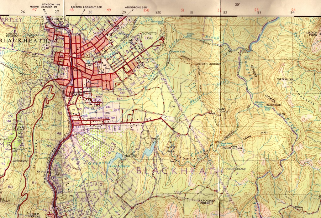

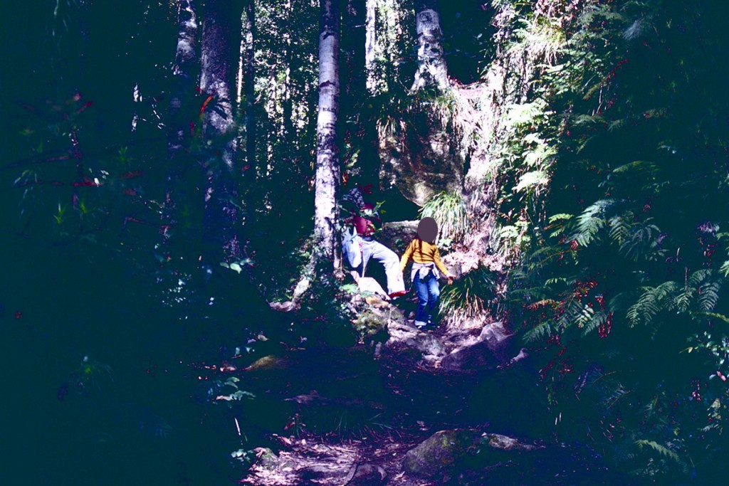
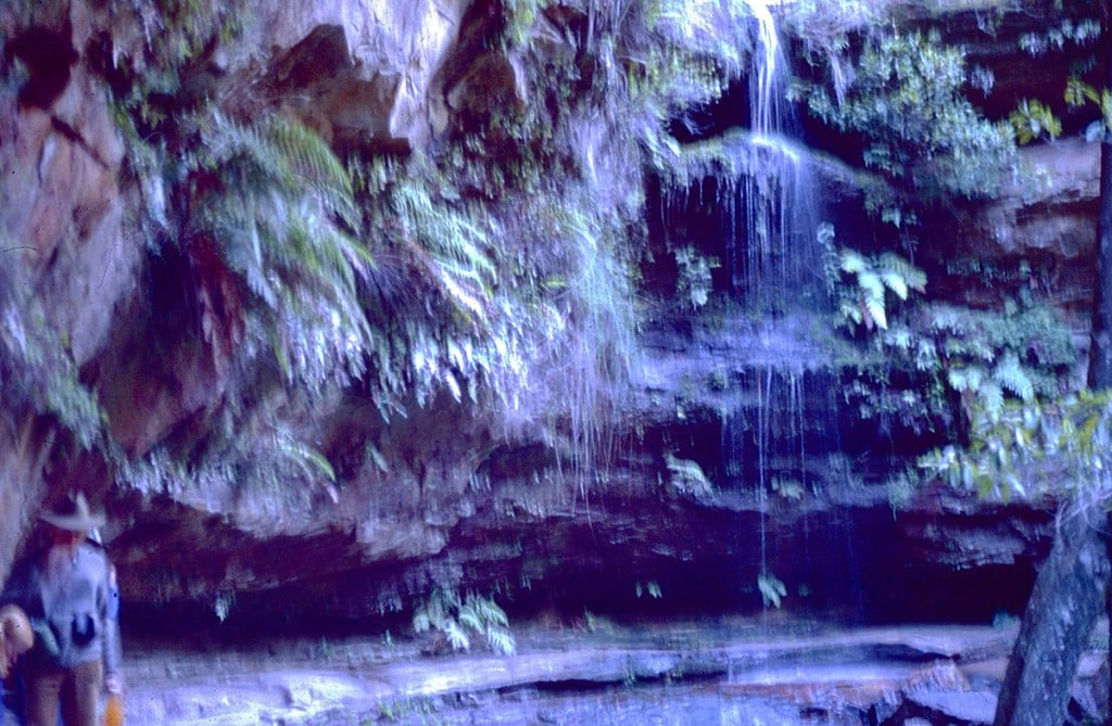
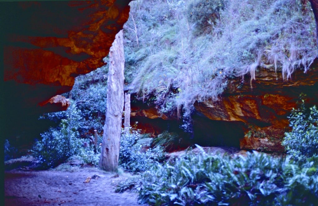
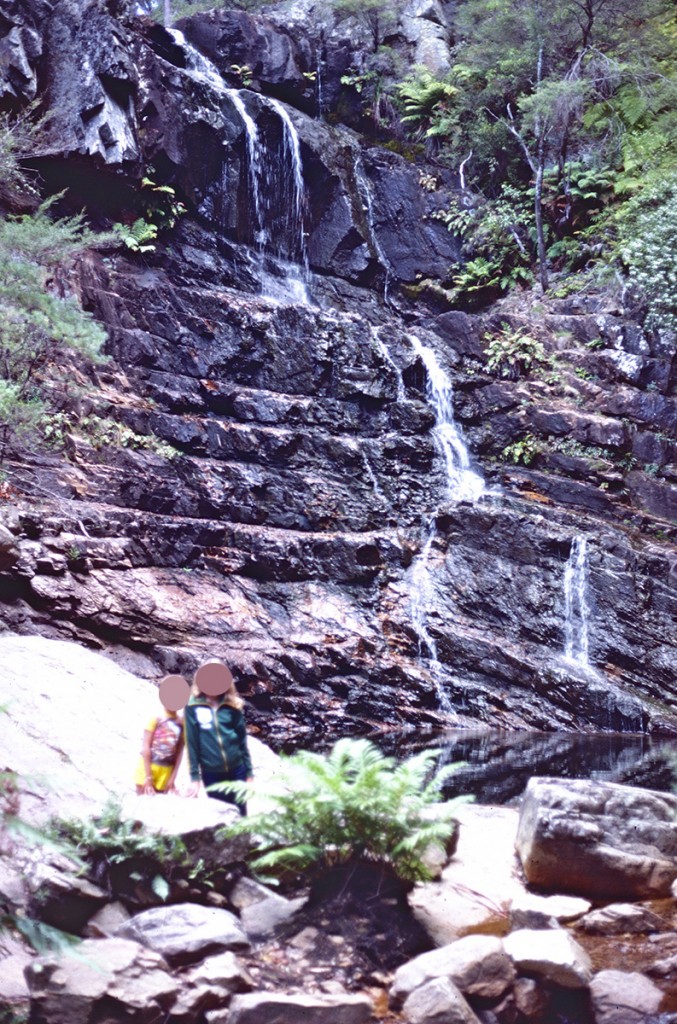

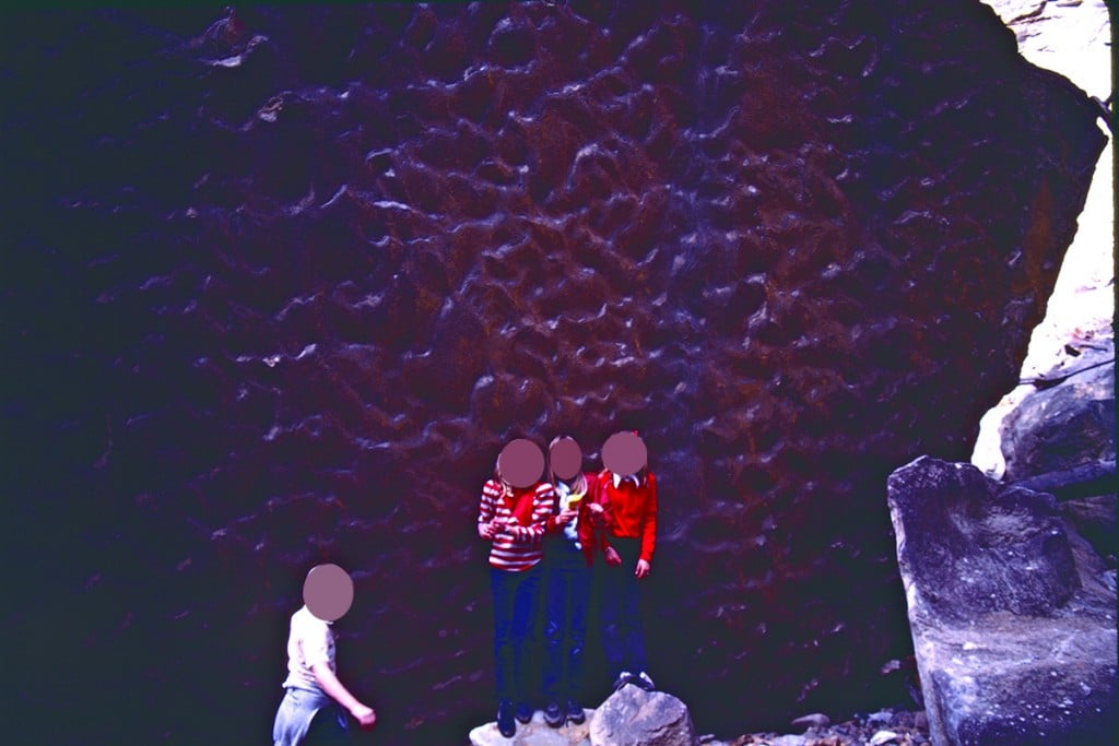
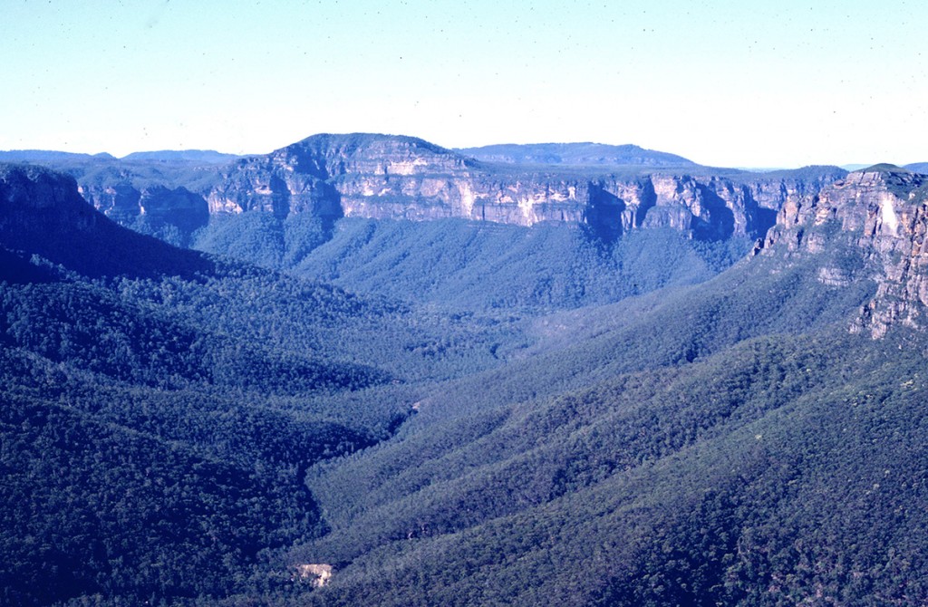
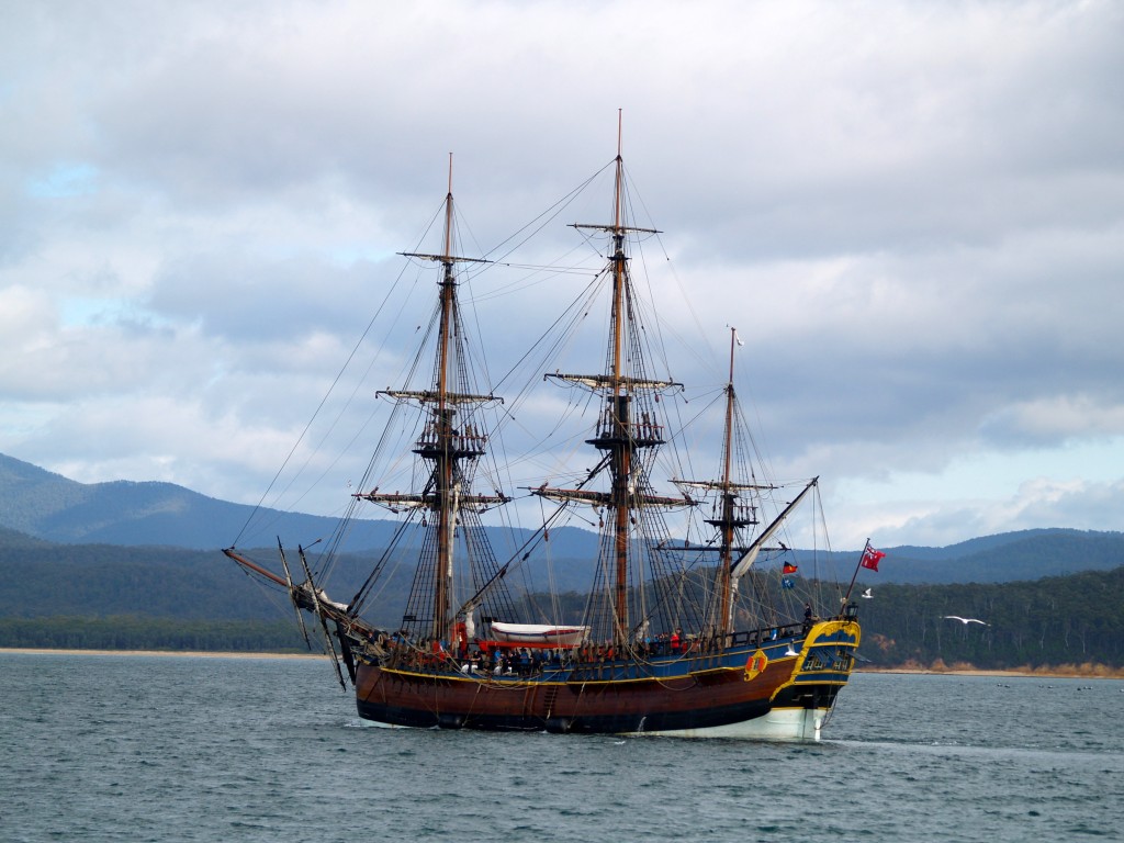

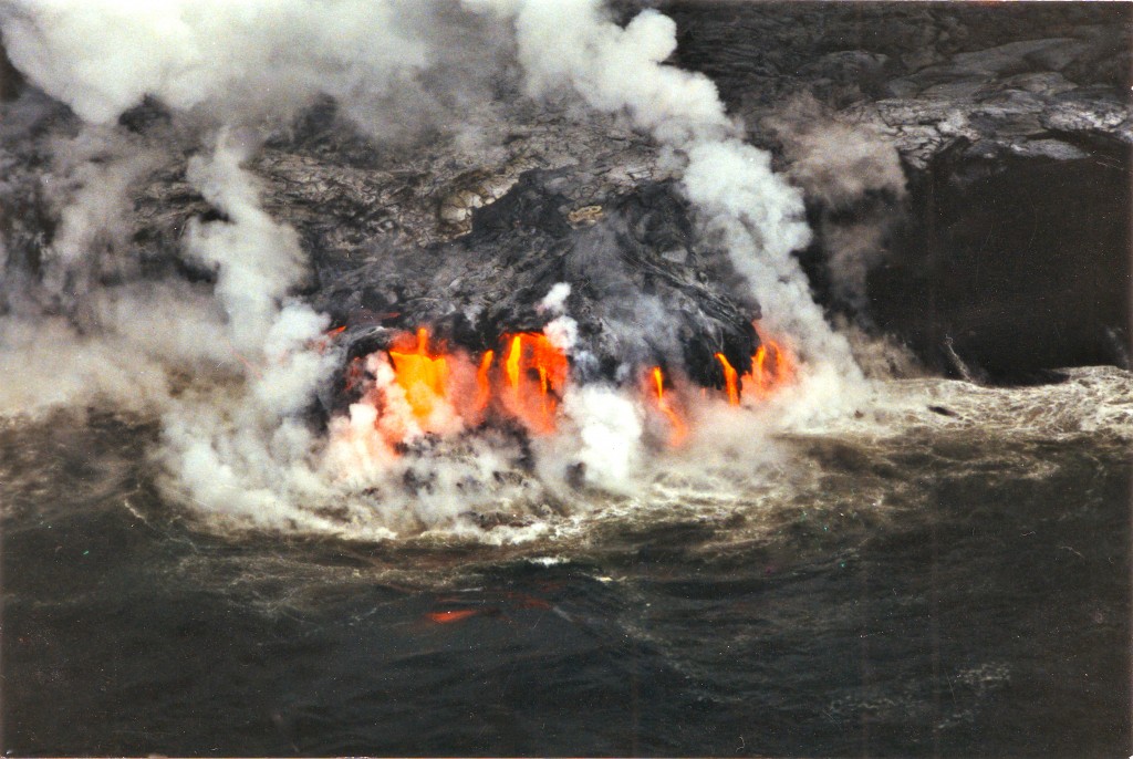
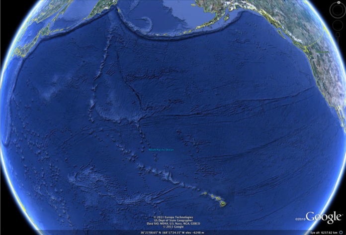
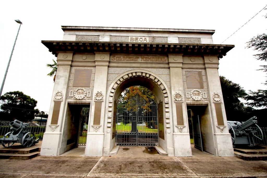
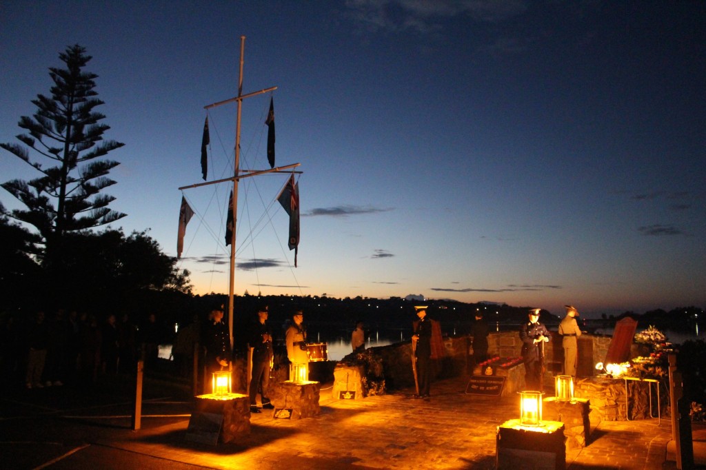


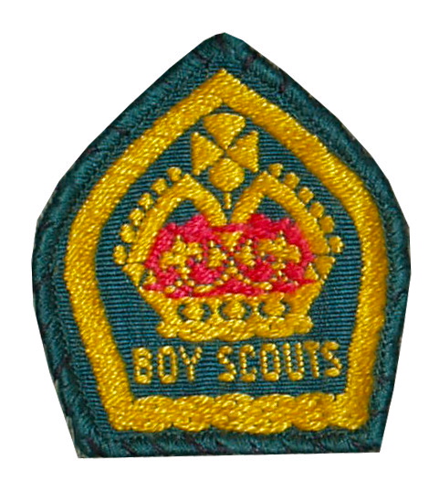
![By Louise Docker from sydney, Australia (Flickr) [CC BY 2.0 (http://creativecommons.org/licenses/by/2.0)], via Wikimedia Commons](https://rossmannellcomments.edublogs.org/files/2015/05/512px-Old_bakelite_phone-2fjep5p.jpg)
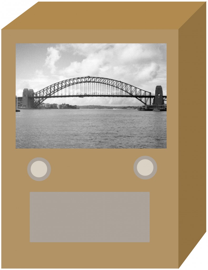
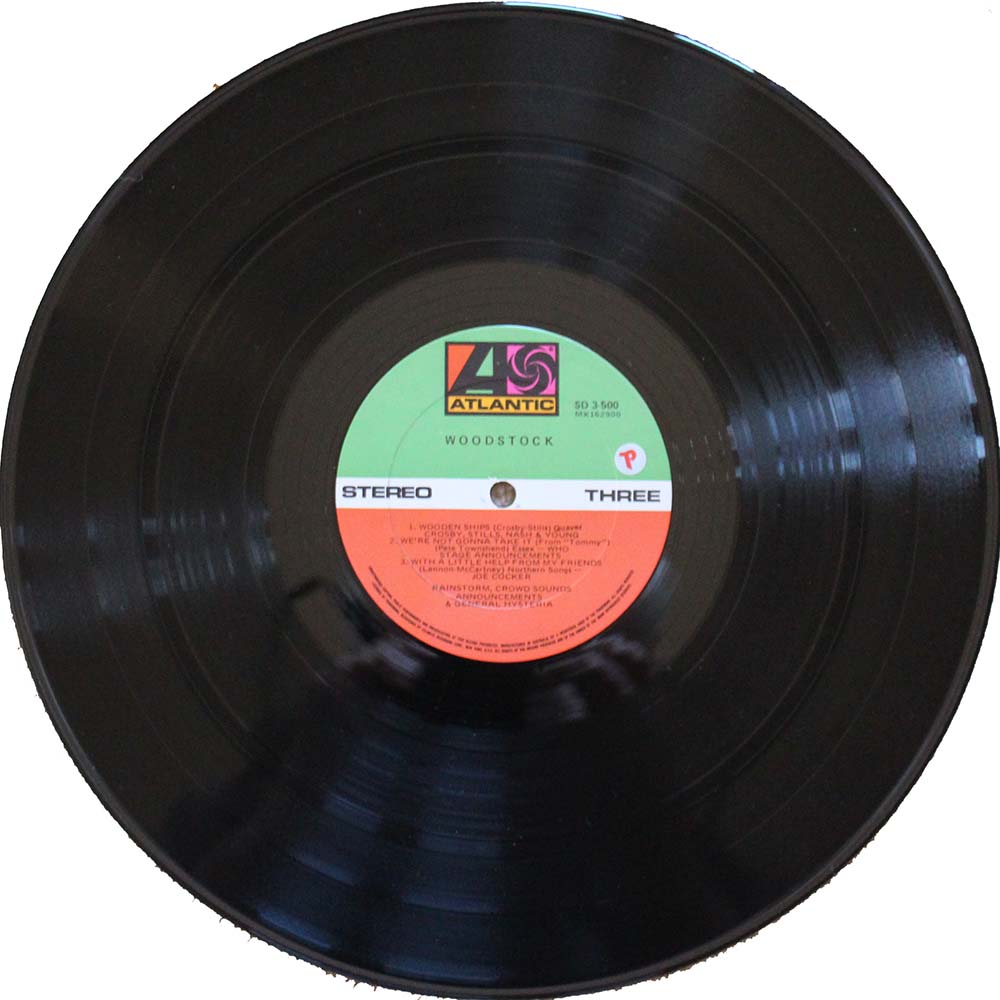
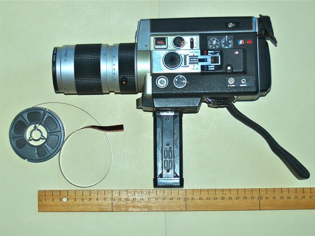
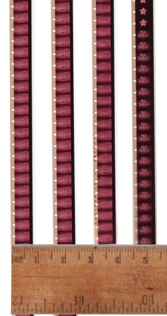
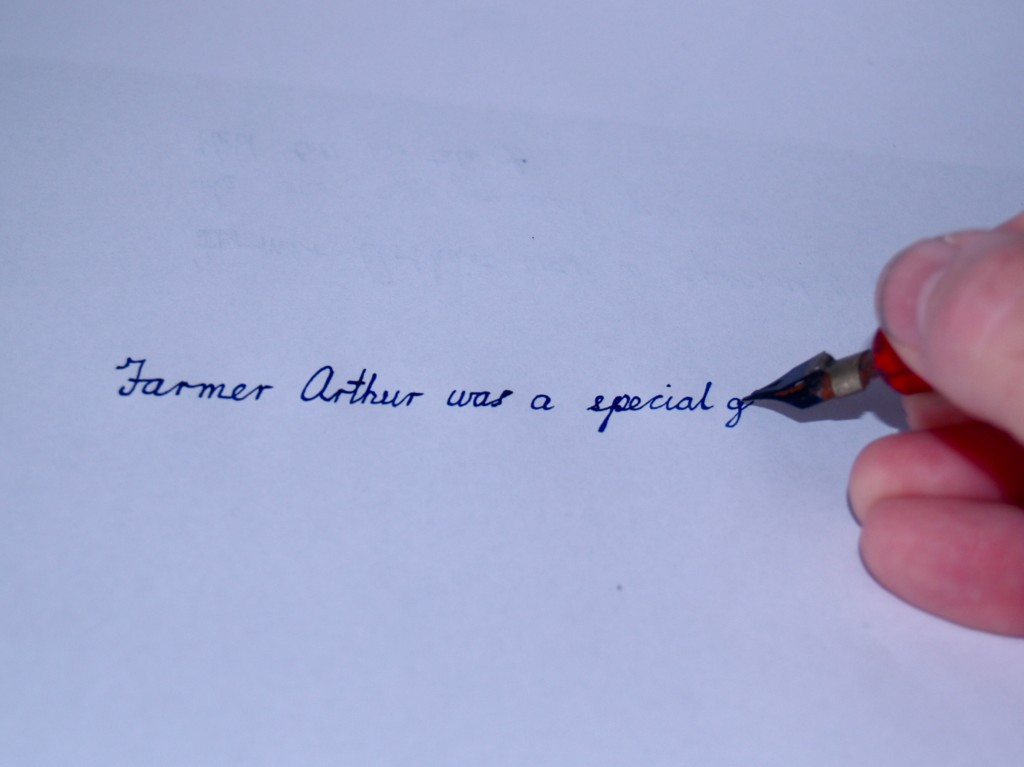
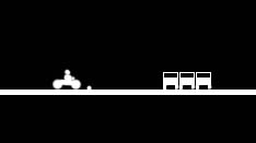
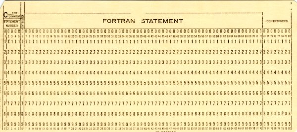
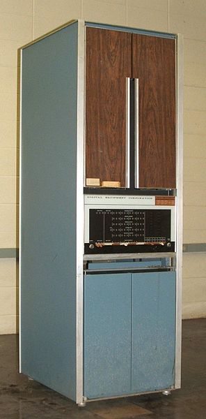
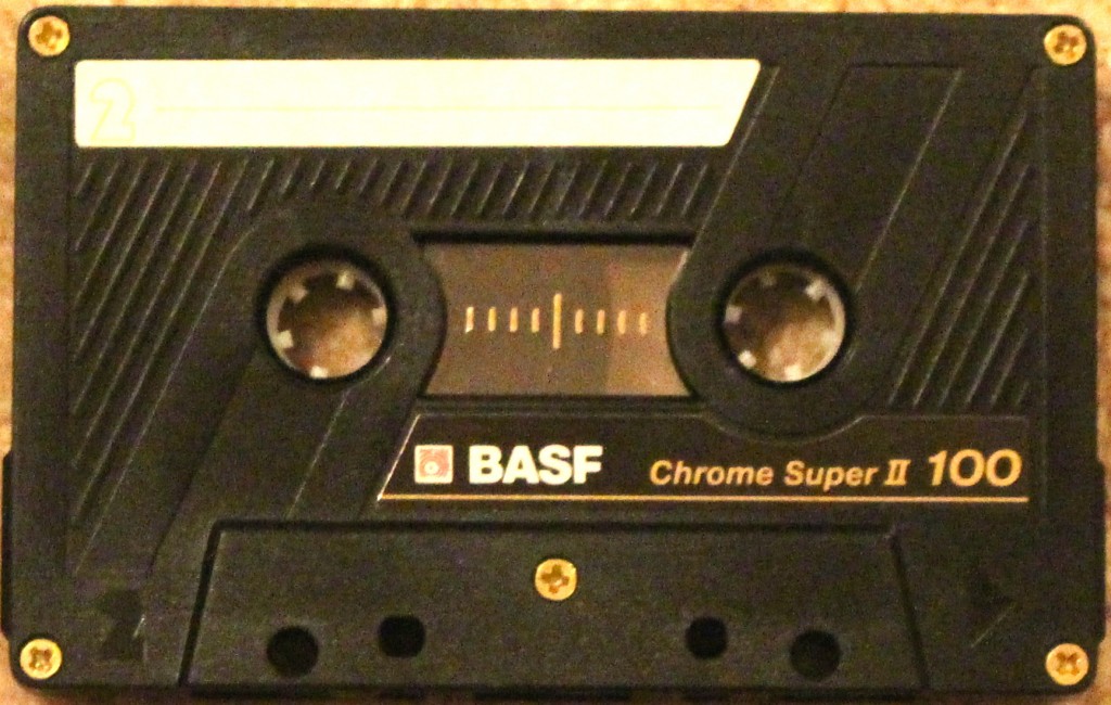
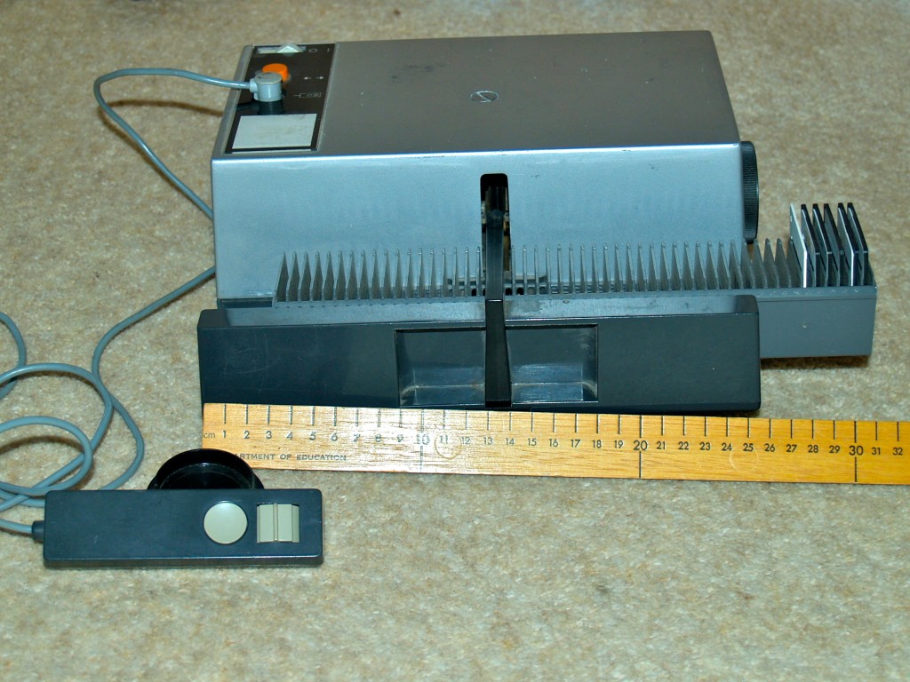
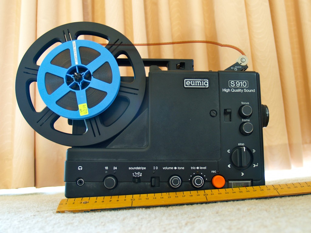

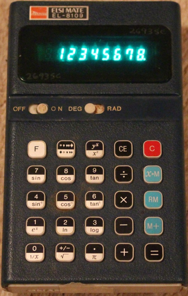

![Rama [CC BY-SA 2.0 fr (http://creativecommons.org/licenses/by-sa/2.0/fr/deed.en)], via Wikimedia Commons](https://rossmannellcomments.edublogs.org/files/2015/05/1024px-Apple_II_IMG_4214-s7ls93.jpg)

![By Alison Cassidy (Own work) [GFDL (http://www.gnu.org/copyleft/fdl.html) or CC BY-SA 4.0-3.0-2.5-2.0-1.0 (http://creativecommons.org/licenses/by-sa/4.0-3.0-2.5-2.0-1.0)], via Wikimedia Commons](https://rossmannellcomments.edublogs.org/files/2015/05/756px-Apple_IIGS_Woz-1btd3ve.png)
![The copyright holder of this image, Christopher Down, allows anyone to use it [Attribution], via Wikimedia Commons](https://rossmannellcomments.edublogs.org/files/2015/05/640px-Gameboy_Advance_On-2glb3dw.png)
![By Gmhofmann at de.wikipedia (Own work) [Public domain], via Wikimedia Commons](https://rossmannellcomments.edublogs.org/files/2015/05/640px-QuickTake_vorne-17md3wn.jpg)