My 6 word autobiography: Seeking ways to make a difference. This blog provides more information packed comments than possible in blog comments. I'm not an expert in any field but interested in many. Content is open to correction if needed.
Your rock has certainly caused much thought as we have tried to uncover its secrets. Science can be like that, a chance to uncover mysteries. After leaving a reply to Heather's quality comment, I found you also left a quality comment.
Here is a link to the information I shared with Heather...
Do I know why your rock looks amber on the outside?
From the picture, I'm not able to see the amber colour on the outside. It may be just the remainder of stone or dirt once surrounding your rock. Look at these photos. The first shows a collection of four geodes, one complete. The second shows a geode containing amethyst (mauve quartz). If you look closely, you can see the colours on the outside aren't always the same as the colours inside the geodes. There are other minerals probably once from the surrounding rock. Did you notice one in the top photo has a yellowish outside?
Schools and students have permission to use this graphic for non-commercial, educational purposes.Schools and students have permission to use this graphic for non-commercial, educational purposes.
It's also possible some citrine quartz crystals might have started to form on the outside. The picture below shows citrine quartz in the paler rock. We can't be certain unless your rock is checked but, no matter what is on the outside, I found your rock very interesting.
Schools and students have permission to use this graphic for non-commercial, educational purposes.
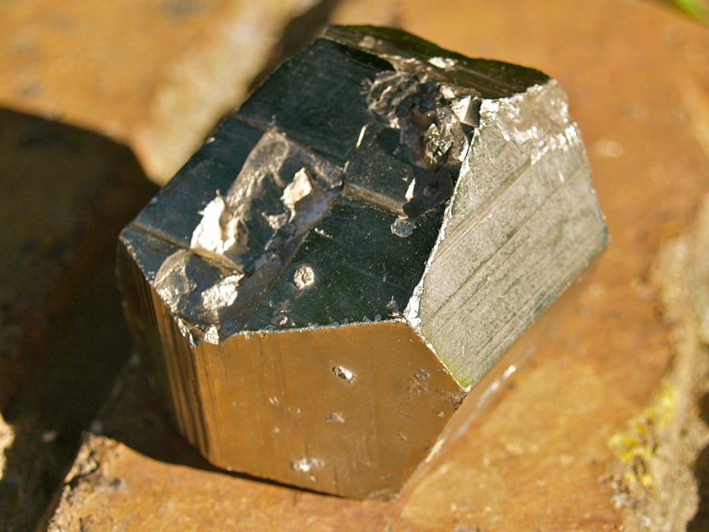
About Galena
Schools and students have permission to use this graphic for non-commercial, educational purposes.
I like your description of galena. It does look a little like tinfoil. Tin (Sn) is an element as is the metal in galena. Galena is lead sulfide (PbS). It's where we get much of the lead (Pb) we use. Below is the heaviest sample in my collection. It's not the biggest in size but weighs 2500g (5.5lb). The gold coloured part of the sample is iron pyrite. It also contains zinc (Zn) but is mostly lead (Pb) in the form of galena. The small whiter patches on the lower left are quartz. The sample comes from one of my state's major mining areas, Broken Hill.
Schools and students have permission to use this graphic for non-commercial, educational purposes.
Click on GALENA and it will take you to a Wikipedia page on galena. You will see where it can be found around the world and in U.S.A..
How do you find out all these facts?
I have been interested in very many subjects over the years. When I see something interesting, I sometimes remember facts and information I think might be useful in an extended comment. As I write, I start looking for more information and learn as I go.
For geology, I have assorted books and I can also search online. I always try to check the information I share on blogs because I'm not an expert in any area. Like you, I'm a learner. I've just had more time to learn.
Where did you get all these rocks?
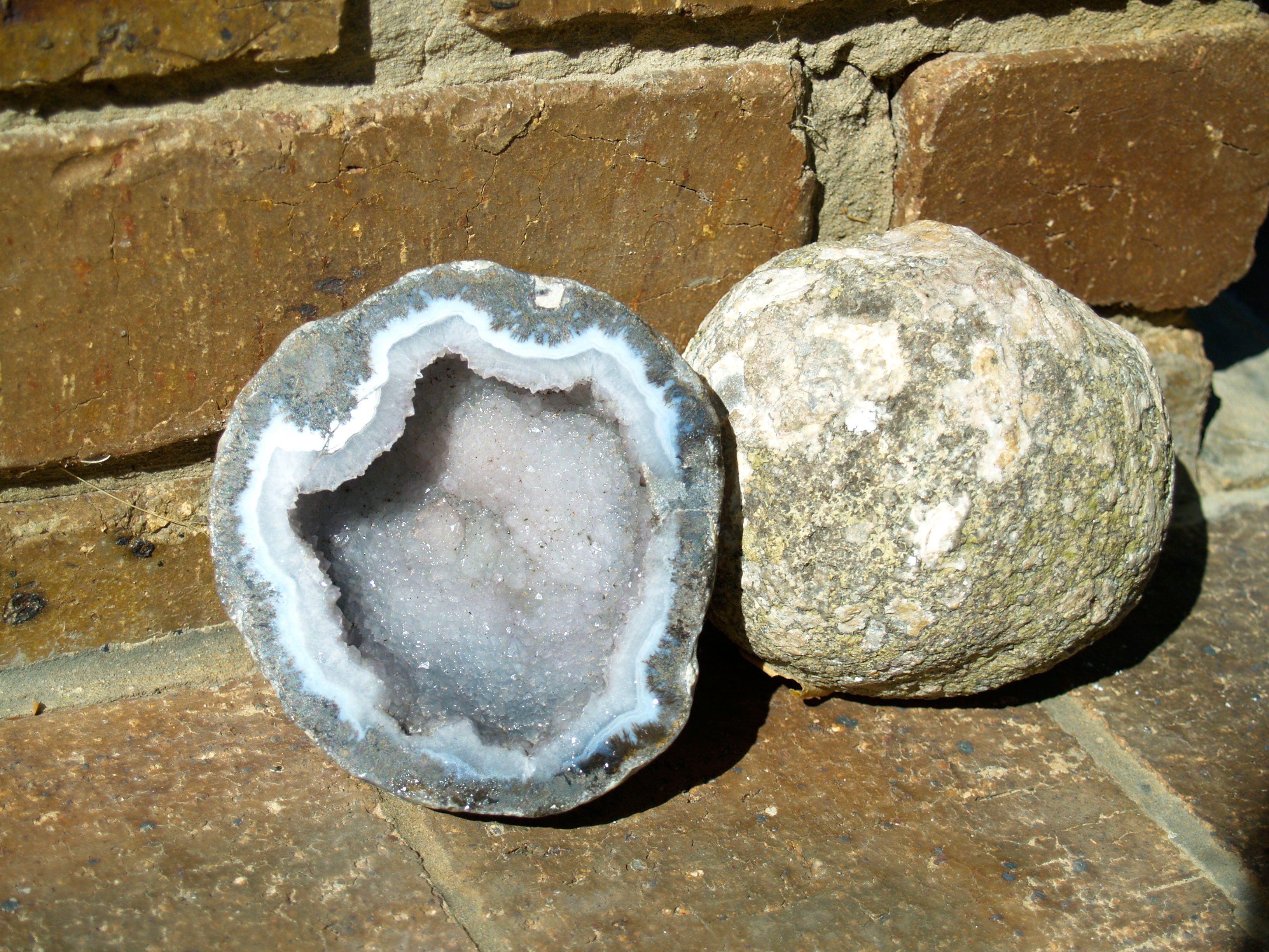
Most of the samples I have were bought in rock shops with only some being collected by me. Many come from countries I have never visited. As an example, the big round geode and the one cut in half beside it are from Brazil. While it can be fun searching for your own samples, collectors often have to buy samples of rarer minerals or ones found in other countries. I have been collecting stones and crystals since I was about your age. It's just a matter of keeping your eyes open in many cases. Look at these...
The first sample caught my attention because I could see crystals in it. Could it be a geode waiting to reveal something special inside? Perhaps I might one day break it open to find out.
Schools and students have permission to use this graphic for non-commercial, educational purposes.
This one is a geode from Queensland. You can see the crystalline mass in it. Perhaps cut and polished, it could look very good but I like it as it was found.
Schools and students have permission to use this graphic for non-commercial, educational purposes.
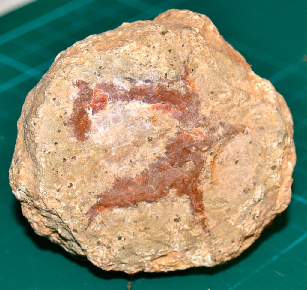
This rock was very interesting when I found it. You can see it also has a yellowish exterior like your rock but some chips broken off the rock have revealed what could be agate. I suspect this sample could look very impressive if cut and polished. The material inside might look like your rock. As I don't have access to a diamond saw to cut it, I keep it as it is, a mystery.
Schools and students have permission to use this graphic for non-commercial, educational purposes.
A Hand Painted Geode?
"...Geodes, the first one looks interesting to me. The middle almost looks like it is hand painted. Was the middle polished or was it like that when you discovered it?"
Schools and students have permission to use this graphic for non-commercial, educational purposes.
I must say this sample looks as though it's the work of an artist. What I believe has happened is, as different minerals have mixed as the crystals formed in a space, different colours were formed. In this geode, crystal growth has filled the space.
I saw this cut and polished sample in a rock shop. It was the pattern you noticed that caught my attention.
In the middle of the rock that is cut open it looks like there is a little nook. Am I right?
Schools and students have permission to use this graphic for non-commercial, educational purposes.
You are a very observant person. There does seem to be a little nook in the cut rock but it is due to the way the crystals have grown inside the geode. Along the inner cut edge, you can see the crystals aren't even like a circle but have some areas thicker than others. This unevenness means some areas extend out over the others. Sunlight on them leaves a shadow below. In the shadowed area, the crystals look much like the small crystals in the middle.
Considering your curiosity and interest in rocks, I hope you keep learning and discovering. A mind with curiosity can be a very powerful learning tool.
Heather provided a quality comment needing to have a reply including a little more than words.
What Stone Is That?
This photo was supplied by Mrs. Yollis and class.
Heather, one of the best things about sharing learning through blogging is the way we can exchange ideas so easily no matter where or how far we are apart. Your comment was an example where we both learn from each other. Reading what you shared, I realised I would need to share extra graphics to give you some answers.
Your suspicion the rock might have been microline had me examine the microcline more closely, something you can't do easily from a picture. When I looked closely, the way the crystals had formed suggests Keira's rock wouldn't be microline. Her rock looks too smooth to match the microcline sample I have. Your observation was good even if it may not be correct. My suggestions might also be wrong. It's by presenting different ideas and solutions science gets understanding. Your comment meant I had the chance to think about and research other ideas. 🙂
How Quartz/chalcedony/agate forms...
A concentric, banded, fibrous variety formed by precipitation from watery solutions in rounded cavities in lava rocks (geodes), sometimes with beautiful clusters of rock crystals or amethyst at the centre.
It was a little unfair of me to leave just the above without explaining it so I was impressed you asked for a simplified explanation. It meant you were really trying to understand. Here is an explanation in other words...
A concentric, banded, fibrous - is about the fine layers you see in this magnified part of your class photo. Fine layer after fine layer had built built up making bands in the sample.
This photo was supplied by Mrs. Yollis and class.
formed by precipitation from watery solutions in rounded cavities in lava rocks (geodes) -
Water can absorb many types of minerals, some slowly and some quickly. When the water evaporates, the minerals can be left behind. In some examples, crystals can grow. Here's something you can try. Take salt and dissolve it in warm water or take some sea water, the saltier the better. Put the water in a flat, clear dish (glass is better so you can see under the result) and leave it in a sunny, warm place. Don't move or stir it as this can effect the results.
Over time, the water will evaporate and you will see salt crystals forming. Once the water has all evaporated, you can examine the crystals. Use a magnifying glass to see the finer crystals. Crystals are fascinating. If you see a larger crystal, you might see it has a certain number of sides. How many can you see?
Crystals are growing rocks. We don't consider them alive but they do grow as long as the "watery solution" is still able to provide raw materials. Here are some crystal photos I have taken to show you.
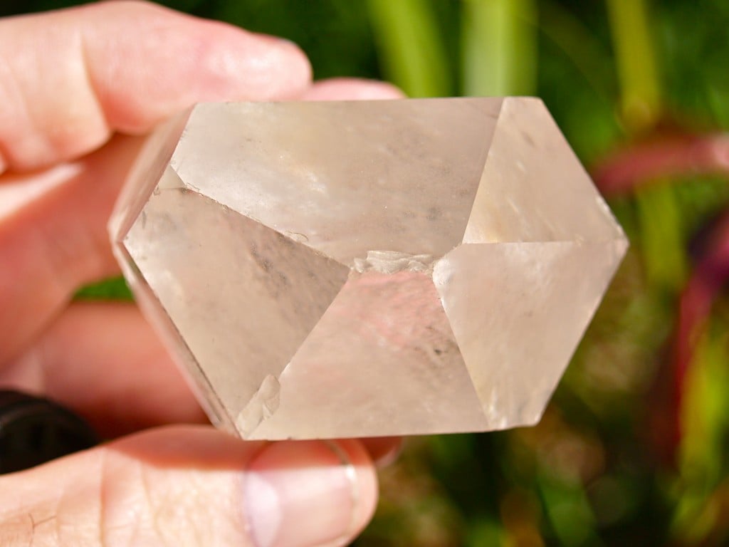
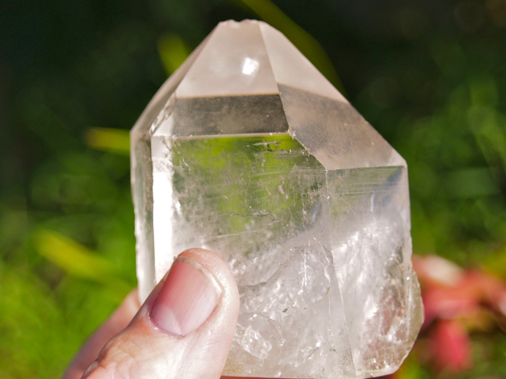
Quartz crystal
You can see quartz crystal has six sides.
Schools and students have permission to use this graphic for non-commercial, educational purposes.Schools and students have permission to use this graphic for non-commercial, educational purposes.
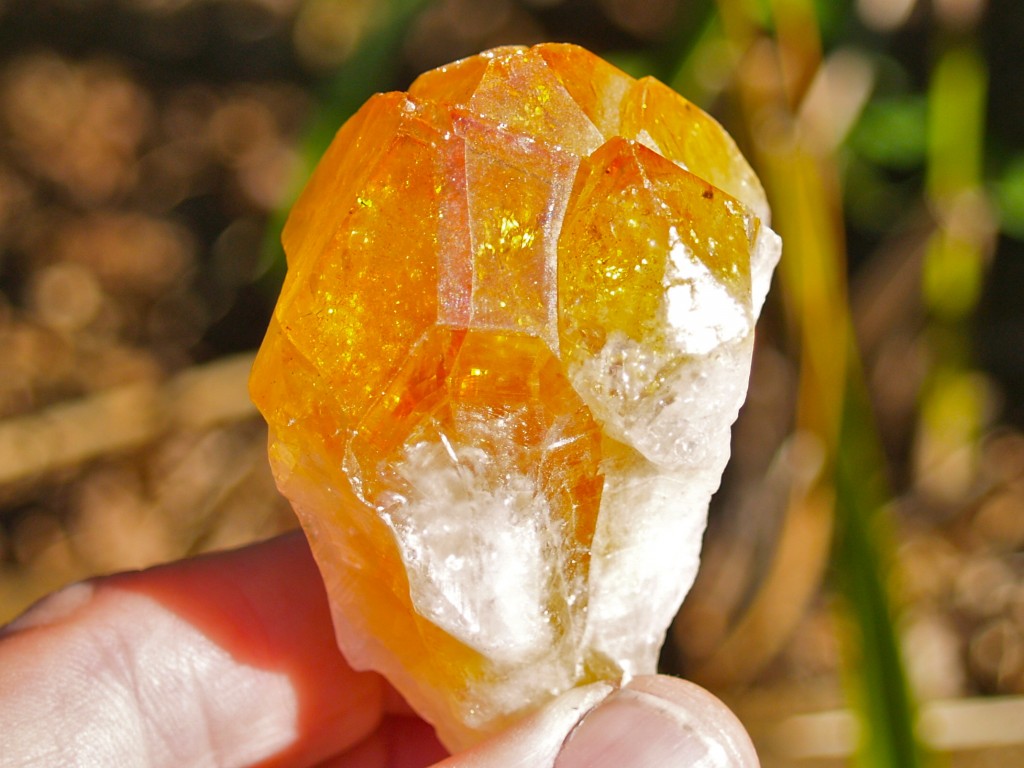
Citrine Quartz Crystal
The different colours in quartz can depend on other minerals dissolved in the watery solutions.
Schools and students have permission to use this graphic for non-commercial, educational purposes.Schools and students have permission to use this graphic for non-commercial, educational purposes.
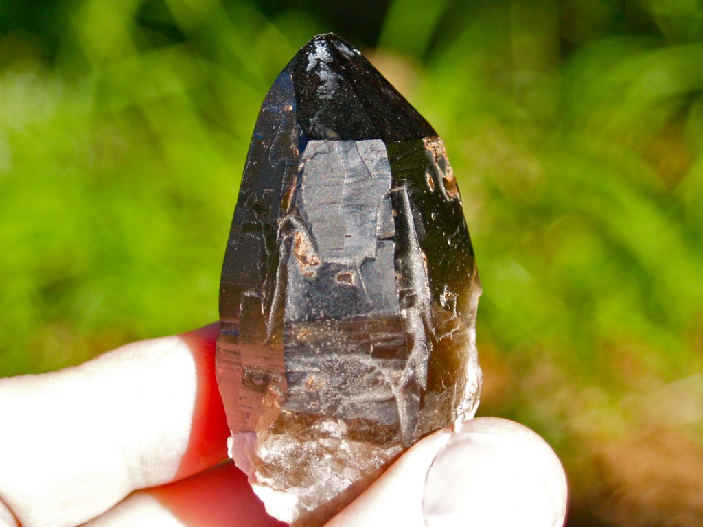
Smoky Quartz
Schools and students have permission to use this graphic for non-commercial, educational purposes.
Amethyst (quartz) Crystals
Schools and students have permission to use this graphic for non-commercial, educational purposes.
Blue Calcite crystal
Schools and students have permission to use this graphic for non-commercial, educational purposes.
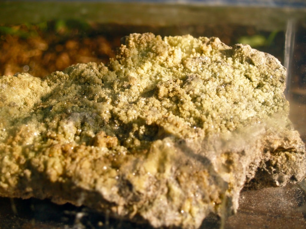
Sulphur (Sulfur) Crystals
This sulphur sample has been inside a sealed container for over 30 years. With permission, it was collected from a fumerole (where gases and steam escape from volcanic areas) in New Zealand. Sulphur (and salt) crystals break down in water so they would have become powdery instead of shiny if not in an airtight container.
Schools and students have permission to use this graphic for non-commercial, educational purposes.
Iron Pyrite (fool's gold) crystal
Schools and students have permission to use this graphic for non-commercial, educational purposes.
Keira's Rock - How did it get there?
Rocks can sometimes be found a distance from where they formed. They can be moved by erosion (the wearing away of rocks by wind and water) or perhaps even movement in the Earth. Let's look at some samples you might recognise...
Gold can often be found associated with quartz rock but is much rarer. Most quartz won't have any gold. Just like other minerals, small amounts of gold can be in water and other fluids (it doesn't really dissolve but can be present in very small amounts). As water evaporates, gold can be left behind in cracks in rocks. If enough gold is carried in enough time, it can build up in amount. The sample of quartz below is from a mine in Hill End, N.S.W.. This is mined gold in quartz.
Schools and students have permission to use this graphic for non-commercial, educational purposes.
If the gold bearing quartz is exposed to wind and rain, larger pieces of gold can be eroded out. This is how we can find gold nuggets in streams and rivers. The below sample is only 0.127oz or about 1/8oz (3.6g). It is only about 1.4cm across. You might even be able to see a tiny quartz crystal in it. This small nugget came from New Zealand.
Schools and students have permission to use this graphic for non-commercial, educational purposes.
Finer pieces of gold can be eroded off larger pieces or out of quartz. To retrieve this gold, panning is often used. I panned some of this in Australia and New Zealand and bought some. The amount is 0.264oz or about 1/4 oz. (7.5g)
Schools and students have permission to use this graphic for non-commercial, educational purposes.
Gold starts it's journey as precipitated (left behind when water dries) gold in rock. It can be mined or found in nuggets and flakes if eroded. Gold, as you know, is used in jewellery and is also import in electronics but my favourite use is to make gold coins. The photo below shows a 0.1oz Australian Gold Nugget coin. It has a diameter of about 1.5cm and its value for the gold content today is about $135 U.S..
Schools and students have permission to use this graphic for non-commercial, educational purposes.
I found one reference to a Californian beach where agates can be found at low tide. The San Francisco Gem & Mineral Society blog post tells us Pescadero Beach about 40 miles (64km) south of San Francisco. If you look at the photos they share, you will see the agates have been rounded by wave action on the rocks and sand.
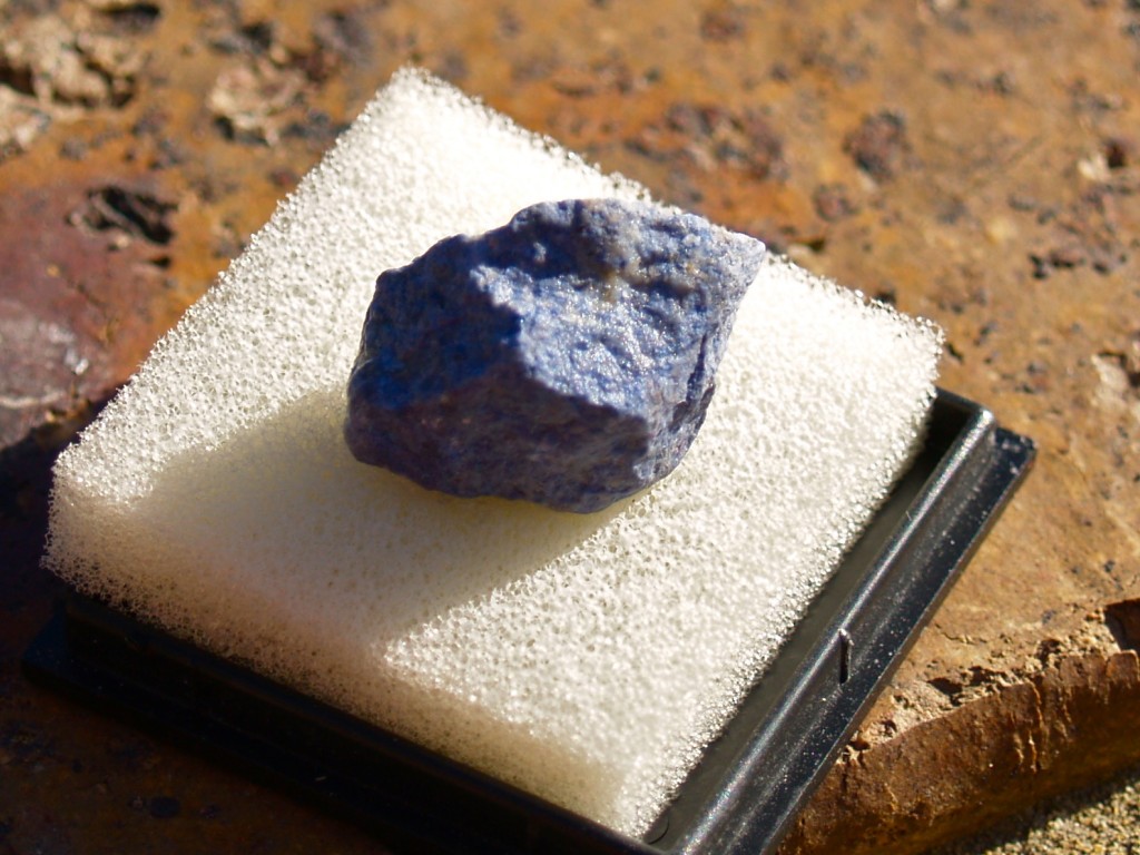
Where Can Azurite be found in Australia?
Schools and students have permission to use this graphic for non-commercial, educational purposes.
Azurite is really a bluish coloured form of copper. The other colours are impurities of other material. There are a number of places it can be found in Australia including, in N.S.W. (Girilambone and possibly to Nymagee), Northern Territory (Areonga), Queensland (Chillagoe) and South Australia (Burra Burra). I think it can be found in the U.S. in Morenci, Arizona.
I have a crystal that looks almost like the purple crystal that was cut in half. My crystal is blue. What kind of crystal is the purple one?
I think the purple crystal you mean is amethyst, a quartz type, shown also above.
There are many crystals and minerals that can be blue, purple, green, red or other colours so it would be hard to say without looking at the stone. Here are some blue, purple, green samples from my collection. They are only small samples and some have been cut and polished.
Amazonite (cut and polished)
Schools and students have permission to use this graphic for non-commercial, educational purposes.
Apatite
Schools and students have permission to use this graphic for non-commercial, educational purposes.
Dumortierite
Schools and students have permission to use this graphic for non-commercial, educational purposes.
Howlite
Schools and students have permission to use this graphic for non-commercial, educational purposes.
imitation (fake) green beryl (cut and polished)
Schools and students have permission to use this graphic for non-commercial, educational purposes.
Lapis Lazuli (cut and polished)
Schools and students have permission to use this graphic for non-commercial, educational purposes.
Lepidolite
Schools and students have permission to use this graphic for non-commercial, educational purposes.
Sodalite
Schools and students have permission to use this graphic for non-commercial, educational purposes.
Zooisite
Schools and students have permission to use this graphic for non-commercial, educational purposes.
How Do I Know So Much About Minerals?
I don't think I do know a lot about minerals but I am interested in them and over the years have collected some. I know enough to get some ideas but my secret is knowing how to find answers when I need them. It could come from one of my geology books or online.
If you were to talk to someone just starting school, they would probably wonder how you knew so much but that's what learning is about. If you keep your mind and senses (sight, sound, touch, smell and taste) open to new things, learning seems to come in to try and fill the space. I'm still learning new things so it seems an open mind is pretty hard to fill. Your questions helped me learn a little more about my collection.
Be a lifelong learner. There's so many interesting things to discover.
A student was learning about Australia and shared some facts and questions. Enjoying reading what was shared, I thought I would provide some information. To see the original Google document...
Here is a summary of information based on your Google document. If you scroll down to "About Australia" on this post, you can read some of the information used to find answers and facts.
There are six Australian states.
The first known Europeans came to Australia arrived in 1606 although the Chinese may have come in the 1400s. People from Indonesia and may have arrived much earlier and the Aboriginal people first came here as much as 60,000 years ago.
Western Australia is our largest state.
There were many language groups in Aboriginal Australia, each with their own cultures. They didn't have tribes like Native Americans.
Australia is the largest island and smallest continent. It is the only continent to be one nation.
Australia has a number of states and territories.
Australia borders the Indian, Pacific and Southern Oceans.
Australia is an island and not landlocked. Landlocked means no access to the sea.
Australia'c capital city is Canberra in the Australian Capital Territory. Each state and territory has its own state/territory capital.
Your questions.
- What are these “parts” called? - The main part of Australia has six states (Western Australia, South Australia, Queensland, New South Wales, Victoria and Tasmania)and two territories (Northern Territory and Australian Capital Territory).
- Why are they so big? - Our states are large because of the arid and semi-arid areas, a much smaller population than the U.S.A. and finding most people live along or near the coast.
- How did they name them? - Northern Territory, Western Australia and South Australia were given their names because of their location. Victoria and Queensland were named in honour of Queen Victoria. Tasmania gained its name from the first European explorer to reach it Abel Tasman. New South Wales was named by Captain Cook. It's said the coast reminded him of parts of Wales in the United Kingdom.
- Who decided to split this country? - The country wasn't really split. Areas gained their names as new colonies were established.
- Who did this? - Each state had a governor representing the king or queen and a government. In a way, each state had been its own country and could set laws.
- How did this happen? - With all the states agreeing after many meetings of state leaders, Australian became a commonwealth and nation in 1901.
- Is it because a historical feature that slowly split them? - The historical feature was colonisation. With large distance between colones, it was better for each colony to control its own area while officially being governed by the king or queen through a governor.
- Was it because of a war? - Australia became a nation by agreement and not war. The English crown also approved Australia becoming a nation.
- When did this happen? - The first British colony was founded in 1788 in an area of Sydney near the now famous Sydney Harbour Bridge. The second colony was established was Van Diemans Land (later Tasmania).
- Why did it happen? - When there was only one colony, the east of Australia and New Zealand were all in the colony of New South Wales. As new colonies were formed, new borders were drawn up and New Zealand separated from New South Wales. Federation in 1901 came about because the states decided they should all be part of one nation.
- When was this discovered? - The borders in Australia were made using rivers or latitude and longitude readings. The changes all came about over time so there was no great discovery.
Read on to see more information on Australia plus links to other blogs.
About Australia
Here is a map of Australia I have drawn...
Schools and students have permission to use this graphic for non-commercial, educational purposes.
The main part of Australia has six states (Western Australia, South Australia, Queensland, New South Wales, Victoria and Tasmania)and two territories (Northern Territory and Australian Capital Territory). It also has jurisdiction over Cocos (Keeling) Islands, Christmas Island and the Ashmore and Cartier Islands in the Indian Ocean and the Heard and McDonald Islands in the Southern Ocean.
The map also shows the capital cities of each state or territory. Canberra is our national capital.
Australia is said to be the world's smallest continent and the world's largest island. Any land mass larger is a continent and any small an island. It's the only continent that is one country. Much of it is arid to semi-arid (desert to very dry areas). You can see on the map cities tend to be near the coast or the wetter eastern coast.
Another student was interested in the "outback" and wanted to know if I'd been there. If you're interested, click the link below and you will see information about a 1985 trip through the Australia's centre.
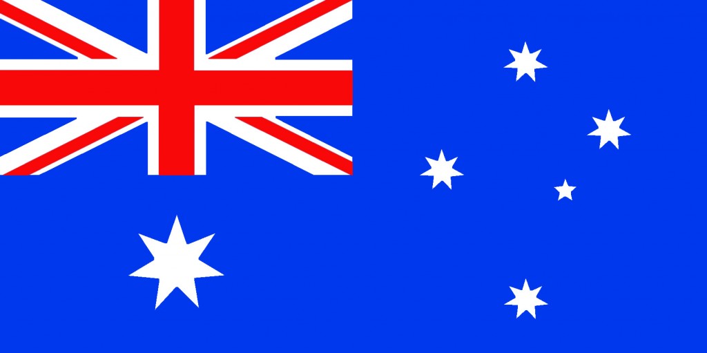
The Australian flag has three major features on a blue background. In the top left hand corner, there is the Union Jack as in the Union Flag of the United Kingdom. The large, seven pointed star under the Union Jack is known as the Commonwealth Star. Six points are for the six states and the seventh is for Australian territories. The five stars at the right represent the Southern Cross (Crux to astronomers). It's always in our sky.
The First Australians
Firstly, it's thought the first Aboriginal people came to Australia from Asia up to 60,000 years ago. At that time the world was cooler and sea levels lower because a polar ice. The islands of Indonesia would have seemed closer because the low sea levels meant coasts were further out. It was possible to walk across dry land from New Guinea to Australia and from the state of Victoria to Tasmania.
Much of Australia was forested with lakes. There is evidence, particularly around the dried lake bed known as Lake Mungo, of thriving people living along its shores. As climate warmed, the land links to New Guinea and Tasmania were covered with water as they are today. Australia's centre started to dry. Forests and lakes disappeared and the Aboriginal people adapted their habits to live in the arid and semi-arid conditions.
Schools and students have permission to use this graphic for non-commercial, educational purposes.
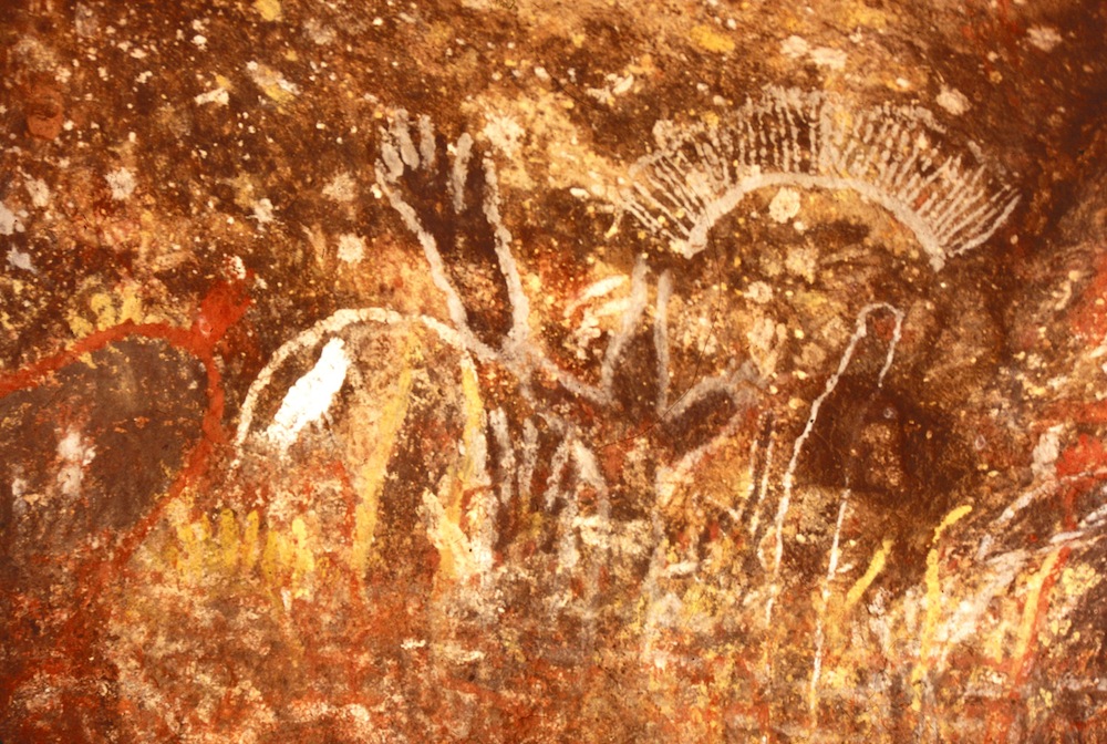
This photo is of Aboriginal art on Uluru (Ayers Rock).
Rather than one tribe, there were many language groups. The Aboriginal people didn't really have tribal groups as the Native Americans have. My area of Australia is Yuin land. There were many language groups and different beliefs across Australia. Each were rich in culture and belief. Click on this link to see the Aboriginal Australia map.
To find out more about Aboriginal Australia, here is a link to a post I wrote for a class looking at Australia's original people...
This is one side of Australia's dollar note showing Aboriginal designs. It has now been replaced by a coin.
Chinese and European "Discovery"
I've always thought it a little strange when people speak of who discovered Australia. Surely that claim could only go to the first Aboriginal people coming to Australia fifty to sixty thousand years back. Who else "discovered"Australia?
There is apparently some evidence Chinese explorers as early as the 1400s. Between 1405 and 1453, a Chinese admiral sailed a huge fleet of junks south to Timor and so could well have visited Australia.
Here are some of the first known Europeans to make it to Australia were...
1606 William Jansz on the "Duyfken" saw the coastline of northern Australia
1616 Dirk Hartog on the "Eendracht" landed on Western Australia's coast
1642-1643 Abel Tasman reaches Van Dieman's Land (Tasmania)
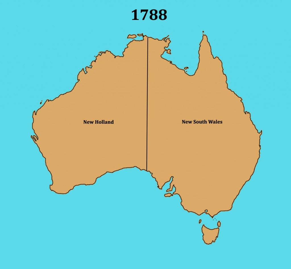
You might have noticed the names are Dutch. The western area of Australia became known as "Hollandia Nova" (New Holland).
The first known Englishman known to have reached Australia was WIlliam Dampier in 1688. He also only reached the west coast of Australia. It wasn't until 1770 before the first European sailed along Australia's east coast.
This graphic was sourced through Wikimedia Commons and is listed as in the public domain in U.S.A..
Captain James Cook's 1769/1770 Voyage
Below is a photo of the H.M.B. Endeavour taken at Twofold Bay, in 2012. It is a replica of James Cook's H.M.S. Endeavour and visited Twofold Bay near my home. If you look at the background, little would have changed since Cook's voyage nearly 250 years ago.
Schools and students have permission to use this graphic for non-commercial, educational purposes.
In 1769, Captain James Cook set sail from England on the "Endeavour". His task was to take scientists to see the transit of Venus from Tahiti in the Pacific Ocean. His other task was to solve a mystery. Many had thought there must be an undiscovered continent south to balance the world's countries up north. Some maps named it Terra Australis (Southern Land). Cook was given the task of once and for all time showing no such land exists.
After heading south from Tahiti, he came to New Zealand in 1769. He mapped the islands before heading west. He first sighted Australia in 1770 at a place named Point Hicks a few hundred kilometres to the south of my home. He made maps of the land as he sailed north, naming it New South Wales.
New South Wales and a British Colony
At this point in Australia's history, the history of the United States overlaps ours. I'm certain you know the importance of the year 1776 for the U.S.A.. When England lost its American colony, they were looking for another place. English prisons were overloaded with convicts and couldn't be sent to America. It was decided to send a small fleet of ships to the land described in Cook's voyage.
Schools and students have permission to use this graphic for non-commercial, educational purposes.
On January 26, 1788, the English flag was raised in the new colony of New South Wales. At this point, New Zealand was also part of New South Wales.
1825 - the border with New Holland had moved to where the Western Australia border now lies. Van Dieman's Land (Tasmania in 1856) became a separate colony.
1829 - New Holland becomes known as the Swan River Colony and Western Australia in 1832.
1840 - New Zealand is no longer part of New South Wales, and the colony of South Australia is formed although it isn't until 1860 when South Australia has the borders we see now.
1851 - The colony of Victoria is formed.
1859 - Queensland is formed as a colony.
1901 - The Commonwealth of Australia is formed by the member states and Australia becomes a nation and not a collection of colonies.
1911 - Federal Capital Territory (Australian Capital Territory in 1938) and Northern Territory are formed.
Each of Australia's states started out as a British colony with their own government, money and banks. With federation in 1901, the states had agreed to join as a commonwealth. There wasn't a war between our states. Our political system is based on that of the United Kingdom. We have a Prime Minister rather than a president and Queen Elizabeth II is recognised as our head of state with a governor-general her representative here in Australia.
Until 1984, Australians sang "God Save the Queen" at official events, the same national anthem as in the United Kingdom. In 1984, "Advance Australia Fair" became our official national anthem. Click on the title below to hear a choir of about 100 sing our national anthem.
Our states are large because of the arid and semi-arid areas, a much smaller population than the U.S.A. and finding most people live along or near the coast. The largest U.S. state by land is Alaska at 1,481,347 square kilometres. With Western Australia being 2,526,786 square kilometres and Queensland being 1,723,936 square kilometres. Alaska would only be the third largest if it were part of Australia.
The area of United States is about 1.3 times larger than Australia yet the U.S. population is nearly 14 times larger than Australia. We have much more space but few people live in much of Australia because of its harsh climate.
Schools and students have permission to use this graphic for non-commercial, educational purposes.
To see more links to Australian information as well as video clips of Australian animals, click the link below...
There was the below photo attached to the tweet...
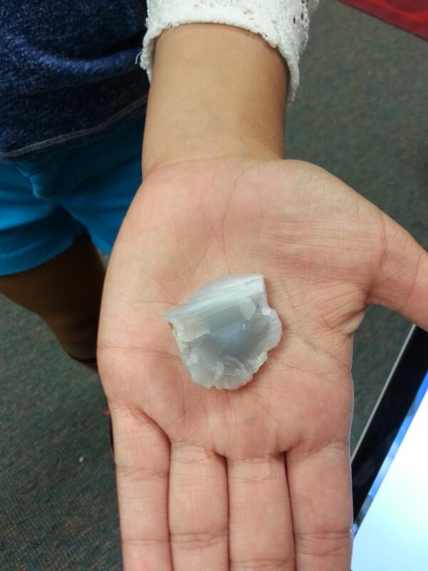
This photo was supplied by Mrs. Yollis and class.
I like a challenge and, although not always successful, finding an answer. I have an interest in geology but l find I know a little about many things but not a lot about anything. Without being able to hold the rock and look more closely, and without expertise, my first stop was to look more closely at the photo. Here's what I noticed...
The stone was white to bluish-grey.
Breaks around the edges looked a little like they might break off in flattened, sharp edged pieces.
There appears to be an inner border (lining) on the stone.
I wanted to see the border closer so I enlarged a section of the photo (below). I also enhanced contrast and colour a little.
This photo was supplied by Mrs. Yollis and class.
I now noticed there seems to have been some fine layering around the edge of the stone up to the border. Layering can mean sedimentary rock but, it can also be a sign of a space in rock filling with crystals. I had seen something like this before. I probably have a few hundred small mineral samples in my collection so I started to search. Firstly, a display of stones I had used with classes over the years...
Schools and students have permission to use this graphic for non-commercial, educational purposes.
A few of these showed some of the features I was looking for, especially calcite, agate and quartz.
Schools and students have permission to use this graphic for non-commercial, educational purposes.Schools and students have permission to use this graphic for non-commercial, educational purposes.Schools and students have permission to use this graphic for non-commercial, educational purposes.
This reminded me of larger samples I had in my minerals database, I found items 41 and 46. They are listed as "Quartz - Chalcedony - Agate". They are examples of silicon oxide (SiO2).
The first sample has been cut and polished. The layering towards the outer edge is easy to see. There are small quartz crystals in the centre of the sample. I have seen this in other of my samples where inner spaces aren't completely filled. See geodes and the additional photos at the end of this post.
Schools and students have permission to use this graphic for non-commercial, educational purposes.
The second sample was a piece broken off a larger sample and only had a low sheen.
Schools and students have permission to use this graphic for non-commercial, educational purposes.
Without being able to hold and examine the sample in Mrs. Yollis's class, I suspect they have a sample of agate or chalcedony. Remember, I am only interested in geology and not an expert so I'm really only guessing.
How is it formed? My database explains it this way...
A concentric, banded, fibrous variety formed by precipitation from watery solutions in rounded cavities in lava rocks (geodes), sometimes with beautiful clusters of rock crystals or amethyst at the centre.
From my collection, below are photos of geodes. Most have been cut and one polished to show the interior.
Schools and students have permission to use this graphic for non-commercial, educational purposes.Schools and students have permission to use this graphic for non-commercial, educational purposes.Schools and students have permission to use this graphic for non-commercial, educational purposes.
The last photo shows one cut sample and an uncut geode beside it. What's inside the uncut geode? I can tell you it is about the same size as the cut geode if it was whole. This means the uncut geode should be about twice the weight of the half but it is around three times the weight of the half. It may be solid or have a small central cavity. It could be very beautiful or possibly plain inside. We'll never know because I won't have it cut. I like a little mystery in the world. 🙂
On Wednesday, October 16, 2013, I was invited to go along on a whale watching trip with people from Potoroo Palace (an animal sanctuary and source for many of my animal photos) on a Go Whale Watching tour. To see the details of what was seen, click the link below...
This post is additional to the observational post and aims to give more information on humpback whales and their migration along the coast near my home.
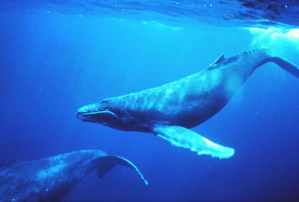
Humpback whales (Megaptera novaeangliae) are members of the balaenopteridae family of cetacea (whales, dolphins and porpoises), i.e. they are not toothed whales. They have a baleen made of a similar material to your fingernails. Their baleen is used to filter out food when they take in large amounts of water when feeding. They feed on krill (like small shrimp/prawns) or small school fish.
One surprising behaviour I have seen in nature programs is the way humpbacks work together to encircle schools of small fish using bubbles they blow. Making the circle of bubbles slowly smaller, they eventually lung up through the school of fish with mouth open taking in thousands of fish in one gulp. The water drains through the baleen leaving the fish trapped.
Migration
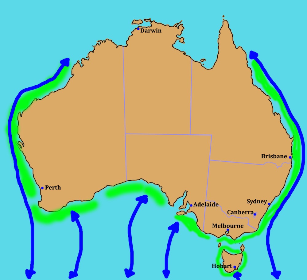
Schools and students have permission to use this graphic for non-commercial, educational purposes.
The green shaded areas are approximate breeding areas for humpback whales.
Humpback whale populations are found in the North Pacific, Atlantic, Indian and Southern Oceans. The Southern Ocean humpbacks are the whales we find migrating along Australia's coast so I will write about those passing my area annually.
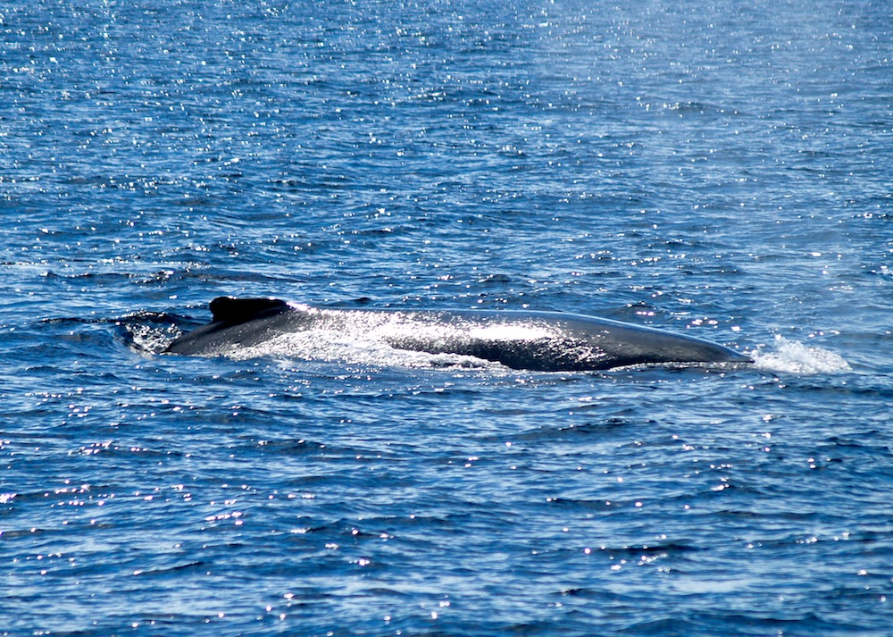
During the summer months, humpbacks feed mostly on krill in Antarctic waters. Although the timing can vary, most head north from June to August and south again from September to November. In northern waters, they don't tend to feed but this is where they mate and females give birth to their calves. The September to November migration gives a good chance to see mothers and calves heading south for summer. The calves take milk and build up fat reserves along the way.
In the photo below taken on October 16, a mother and calf seemed to be at play. The mother's pectoral fin and fluke are to the left and the calf's pectoral fin is at the right.
Schools and students have permission to use this graphic for non-commercial, educational purposes.
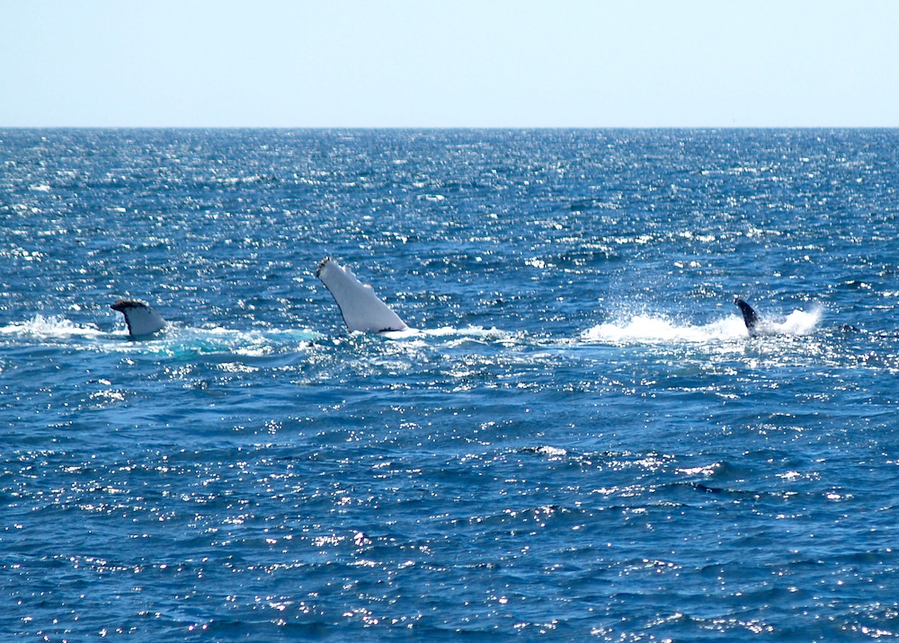
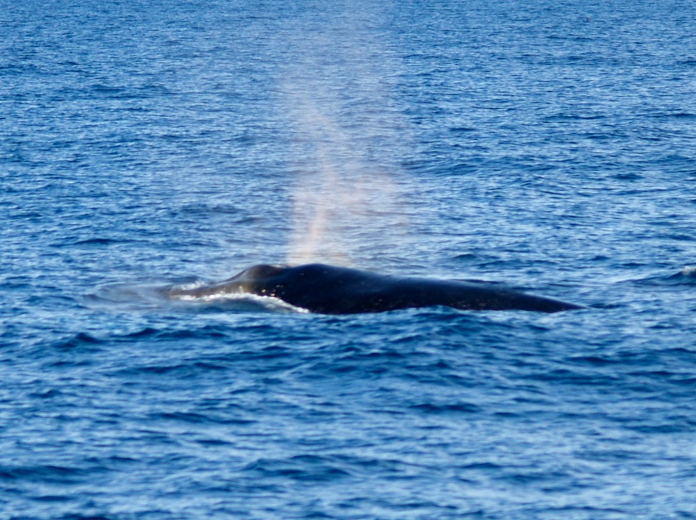
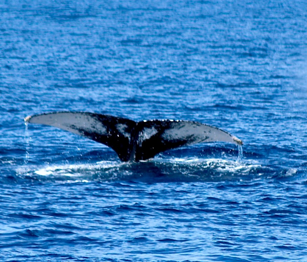
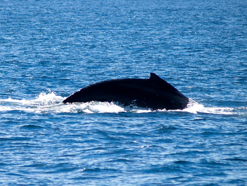
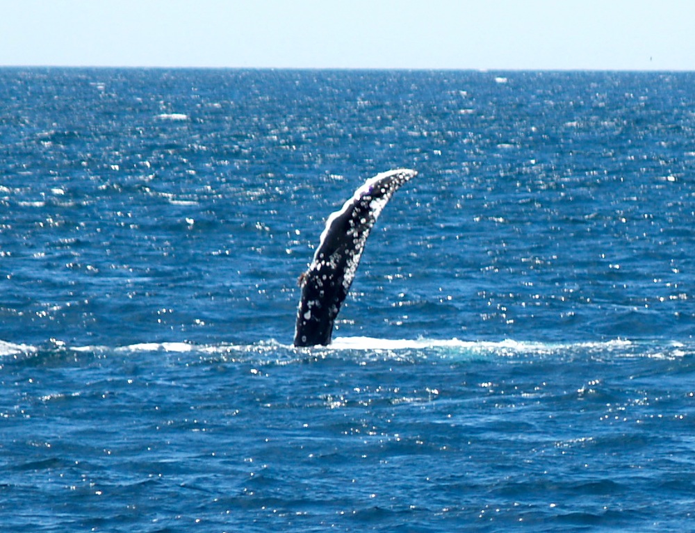
How Will I Know If It's a Humpback?
Humpback whales can be identified by the features you see when they surface. Below are some photos I have taken to help you...
blow
Schools and students have permission to use this graphic for non-commercial, educational purposes.
flukes
Schools and students have permission to use this graphic for non-commercial, educational purposes.
diving
Schools and students have permission to use this graphic for non-commercial, educational purposes.
pectoral fin
Schools and students have permission to use this graphic for non-commercial, educational purposes.
surfacing
Schools and students have permission to use this graphic for non-commercial, educational purposes.
Below is a short video clip made from a series of still photos. It shows a whale blowing and diving.
Whaling in Australia
Whaling had once been a big industry in parts of Australia, including Eden near my home. Whaling along the east coast stopped in 1963. All Australian whaling was banned by 1979. Since then the numbers of humpback whales migrating along our coast has been growing.
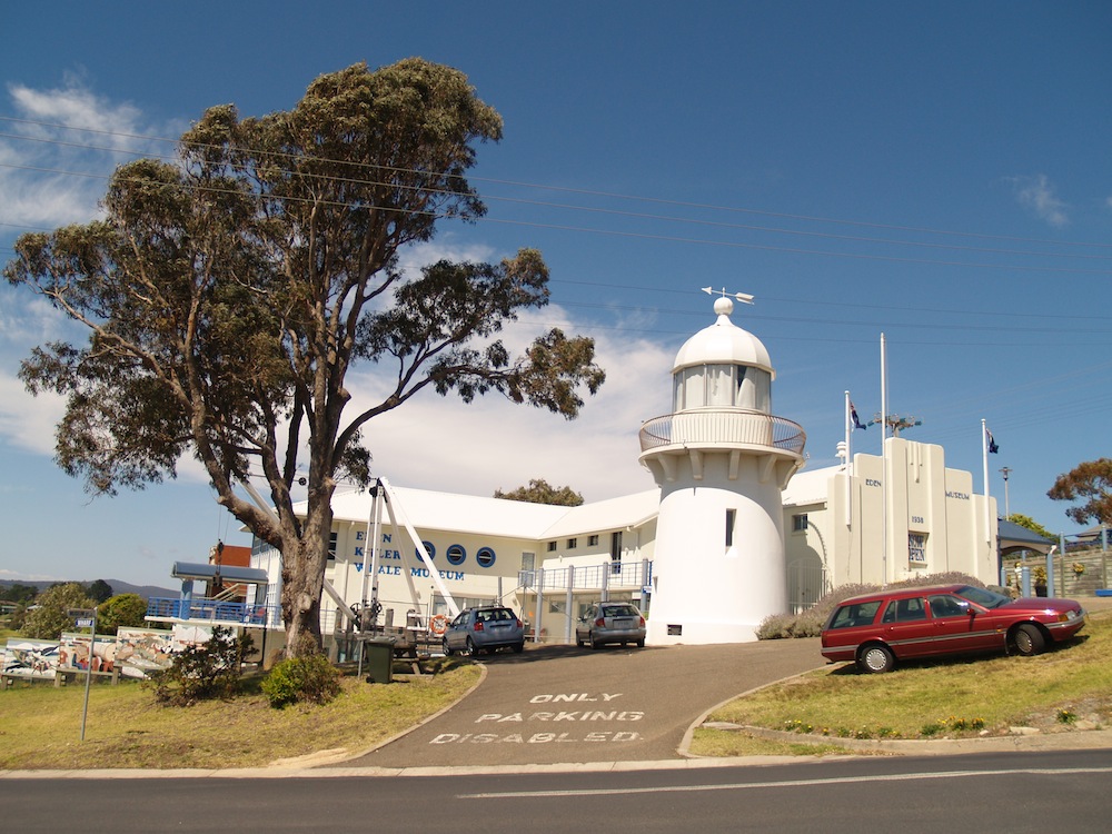
Located in Eden, the Eden Killer Whale Museum has many displays dealing with local whaling history...
Schools and students have permission to use this graphic for non-commercial, educational purposes.
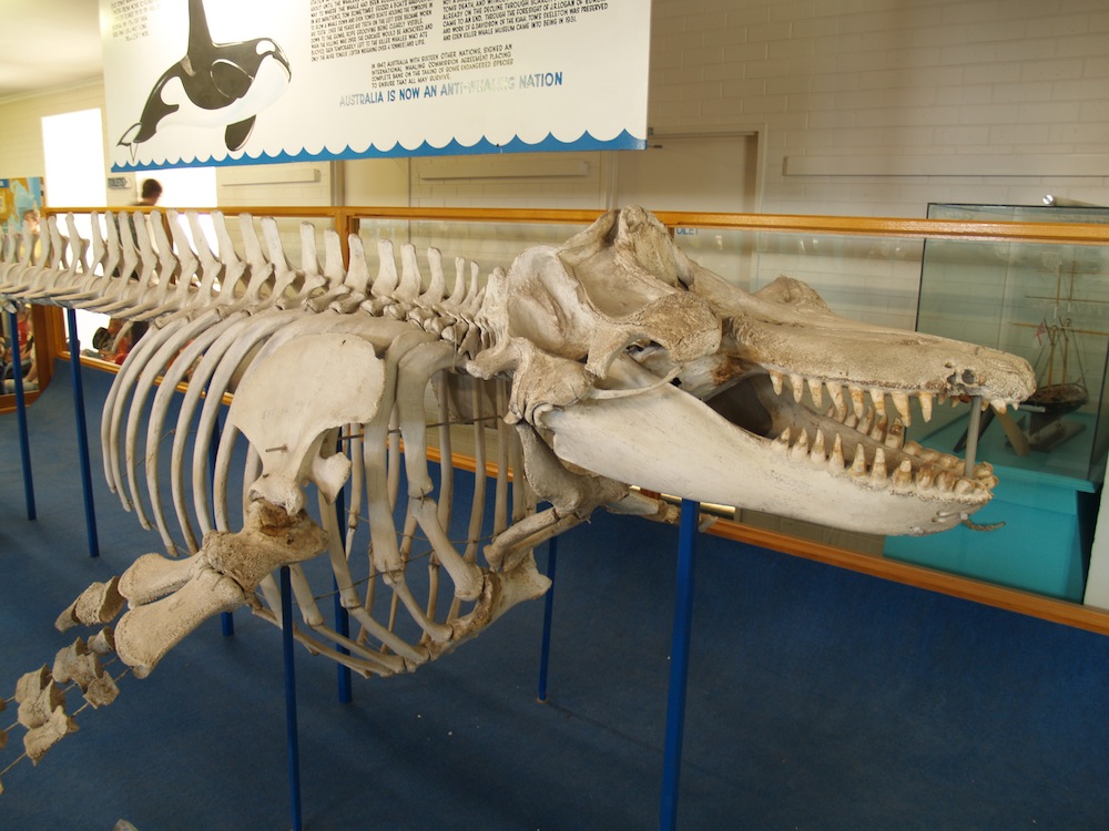
...but perhaps my favourite display is the skeleton of Old Tom, an orca or killer whale (Orcinus orca). Unlike humpbacks, orca are toothed whales. They can feed on fish, sea lions, seals, walruses and even other whales such as the humpback.
Schools and students have permission to use this graphic for non-commercial, educational purposes.
Why is Old Tom so special? Old Tom was said to have had a special relationship with whalers in the past. Old Tom was thought to be the leader of an orca pod. The pod would herd balleen whales into Twofold Bay and help the whalers kill the whales. The orcas would then be rewarded by the whalers with the tongue and lips of the balleen whales. It was said at times Old Tom would hold a rope from a whaling boat to tow it out to the balleen whales. On September 17, 1930, Old Tom was found dead in Twofold Bay. His age was unclear but he could have been up to 80 years old*.
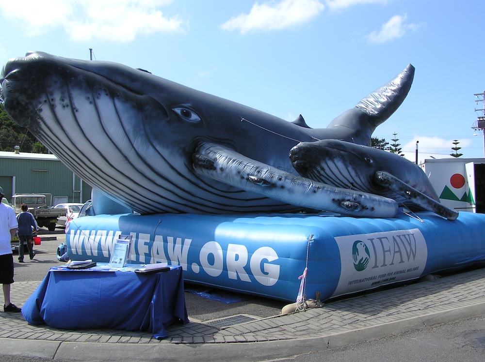
Eden remembers its past with the annual Eden Whale Festival attracting locals and tourists to the parade and festival area where rides, displays and entertainment are available.
Schools and students have permission to use this graphic for non-commercial, educational purposes.
This year (2013) the Eden Whale Festival parade is scheduled for November 2.
* Thanks goes to Jody White, Collection Manager for the Eden Killer Whale Museum, for the updated information on the age of Old Tom. Early 1970s age dating for Old Tom is thought to have been unreliable in placing Old Tom's age at 35.
This graphic has been sourced through Wikimedia Commons and is listed as in the public domain.
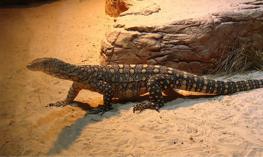
The Perentie tend to live in central Australia across to Western Australia but are not native to my area. Their patterning is very attractive but I have only seen them in zoos and not in the wild. They are one of the monitor lizards.
Lace Monitors
The photo below shows a local lace monitor (goanna) I photographed while hiking. It was about 1.5m long and was seen eating an animal killed on the road. I have seen them a number of times.
Lace monitors are our second largest monitor lizards after the perentie. The perentie and lace monitor are thought to be slightly venomous but they are generally shy and run away if surprised. I have read fossils have been found in Australia showing komodo dragons, the largest of the monitors once also roamed Australia but are now only found in Indonesia.
Schools and students have permission to use this graphic for non-commercial, educational purposes.
Kangaroo, Koalas and Echidnas
I have seen kangaroos (and wallabies), koalas and echidnas in zoos and in the wild a number of times. There has been an echidna in my garden and kangaroos on the sports oval across the road. While wild koalas aren't common in my area, my local animal sanctuary has had them. Potoroo Palace has a female named Sapphire who was born in their sanctuary. I have known her since birth.
All of the video clips shown below were filmed by me at Potoroo Palace.
Kangaroo
The most common kangaroo in my area is the eastern grey kangaroo. The males can be up to around 2m tall and are common in my area. The pictured male was as tall as me. He watched me as I took his photo them he hopped away. They are only dangerous if they feel trapped.
Schools and students have permission to use this graphic for non-commercial, educational purposes.
Here is one of my short video clips showing eastern grey kangaroos.
Koala
The photo shows Sapphire when she was younger but had left her mother's pouch.
Schools and students have permission to use this graphic for non-commercial, educational purposes.
The first of my video clips shows one of the first times Sapphire looked out from her mother's pouch after about 26 weeks inside the pouch.
The second clip shows Sapphire with her mother, Suzie. Too big, Sapphire stayed out of the pouch but with her mother.
With the loss of Blinky (father) and Suzie (mother), Sapphire is now the only koala at Potoroo Palace. I am certain the staff will be hoping for a suitable mate for her to continue their koala breeding.
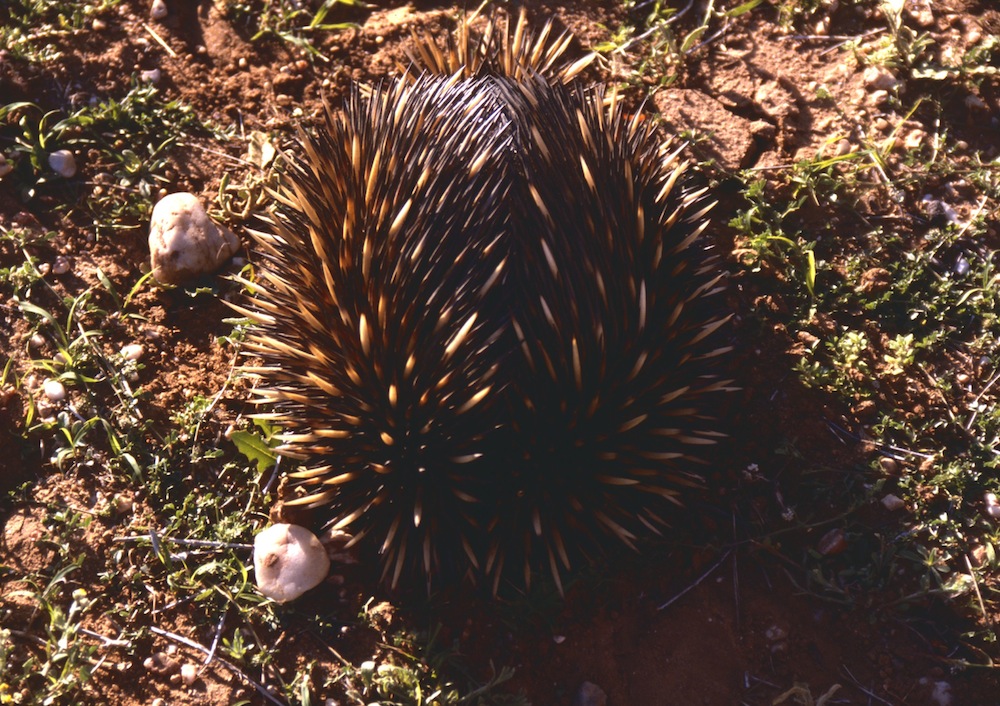
Echidna
I have seen echidna when hiking, in a park in my town and even in my own backyard. Their eyesight isn't good and they can't bite. If threatened, they dig their strong claws into the ground, hold on, and show only their spines.
Schools and students have permission to use this graphic for non-commercial, educational purposes.
This is what they look like when they dig in.
Schools and students have permission to use this graphic for non-commercial, educational purposes.
Below is a video clip of Potoroo Palace's Spike.
The Outback.
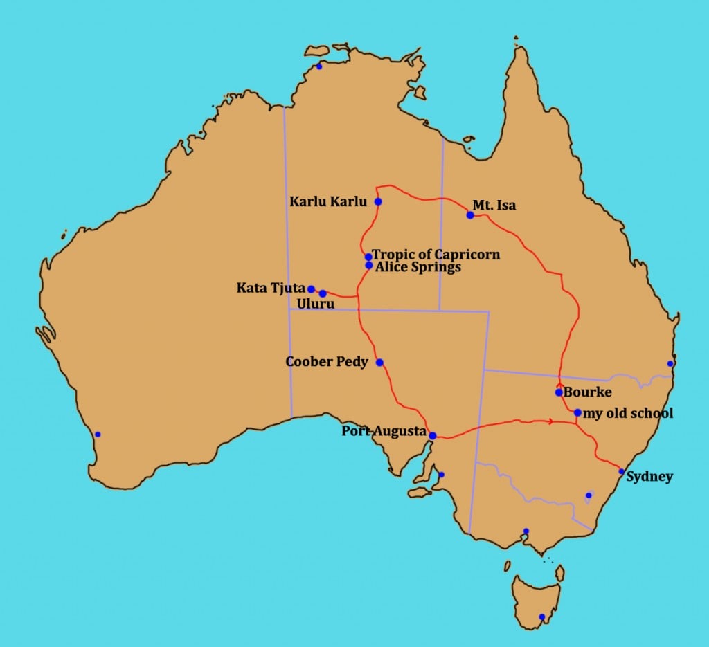
There was an old saying, "Out back of Bourke". Others have talked about the outback starting at the dingo fence or beyond the "black stump", or a number of other areas but, mostly, outback refers to isolated inland areas of Australia. Unlike Canada, much of Australia is arid or semi-arid (deserts or near deserts) where rainfall is low and the soil is often reddish from iron oxides (rust). I'll share some photos, a number just scanned into the computer from old 35mm film slides, so you'll be the first to see them since many were taken back in 1985.
In 1981 and 1982 I was the Teacher in Charge of a one teacher school. It was very isolated and ranked number 6 in our state. Town was 100km away. The school was there for children from sheep and cattle stations. I lived 20km distant in a shearer's quarters on a 100,000 acre sheep station. We did have a computer on loan for about six weeks each year but the internet was still many years away for schools.
Below is a picture from 1982. Does it look isolated?
Schools and students have permission to use this graphic for non-commercial, educational purposes.
1985 - A Trip to Uluru (Ayers Rock)
By 1985, I was a teacher in an 850 student school in western Sydney. In 1983, I had organised a trip for some families to New Zealand but, for 1985, organised a trip through the centre of Australia. I was the 20 seater bus driver for most of the trip of over 7000km. Our first night was spent in the schoolroom of my old school pictured above. From there, we took dirt roads and a main highway until we reached Bourke. From there, we could have said we were in the outback.
Schools and students have permission to use this graphic for non-commercial, educational purposes.
Here are some photos from back then...
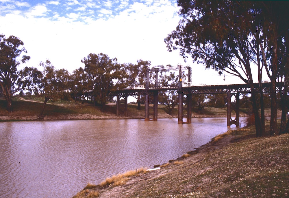
This is the Darling River in the town of Bourke. The Darling River is part of an inland water system stretching from Queensland through New South Wales (N.S.W.), Victoria and out to sea in South Australia(S.A.). In times of severe drought it can run dry or overflow in flood during big rain.
Schools and students have permission to use this graphic for non-commercial, educational purposes.
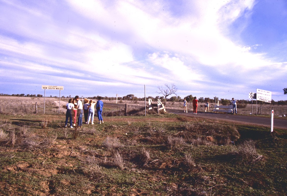
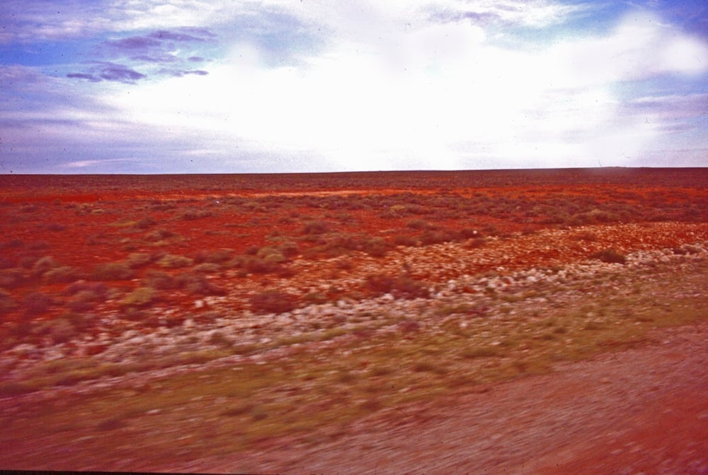
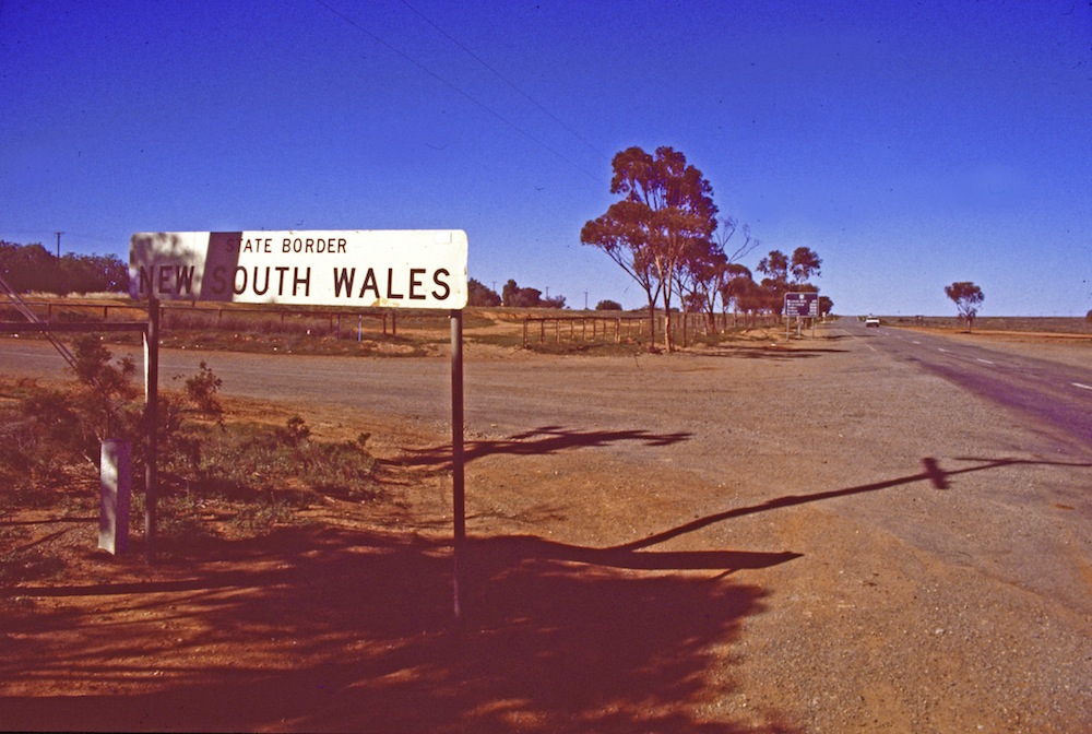
Heading north from Bourke along the Mitchell Highway, we stopped at the state border between N.S.W. and Queensland. The countryside was very flat but green as we had some rain the week before our trip.
Schools and students have permission to use this graphic for non-commercial, educational purposes.
We came to the mining town of Mt. Isa in Queensland. Mt. Isa is in the tropical but dry north of Australia. The red colouring of the soil is caused by iron oxide (rust) in the soil. Lead, silver, copper and zinc is mined there.
Schools and students have permission to use this graphic for non-commercial, educational purposes.
From Mt. Isa, we headed west and crossed into the Northern Territory, heading about half way across N.T.. before heading south to the Red Centre (the middle of Australia). One of our stops was at Karlu Karlu (Devil's Marbles) where there are many large rocks seemingly balanced on their ends. They are important in traditional Aboriginal beliefs.
Schools and students have permission to use this graphic for non-commercial, educational purposes.
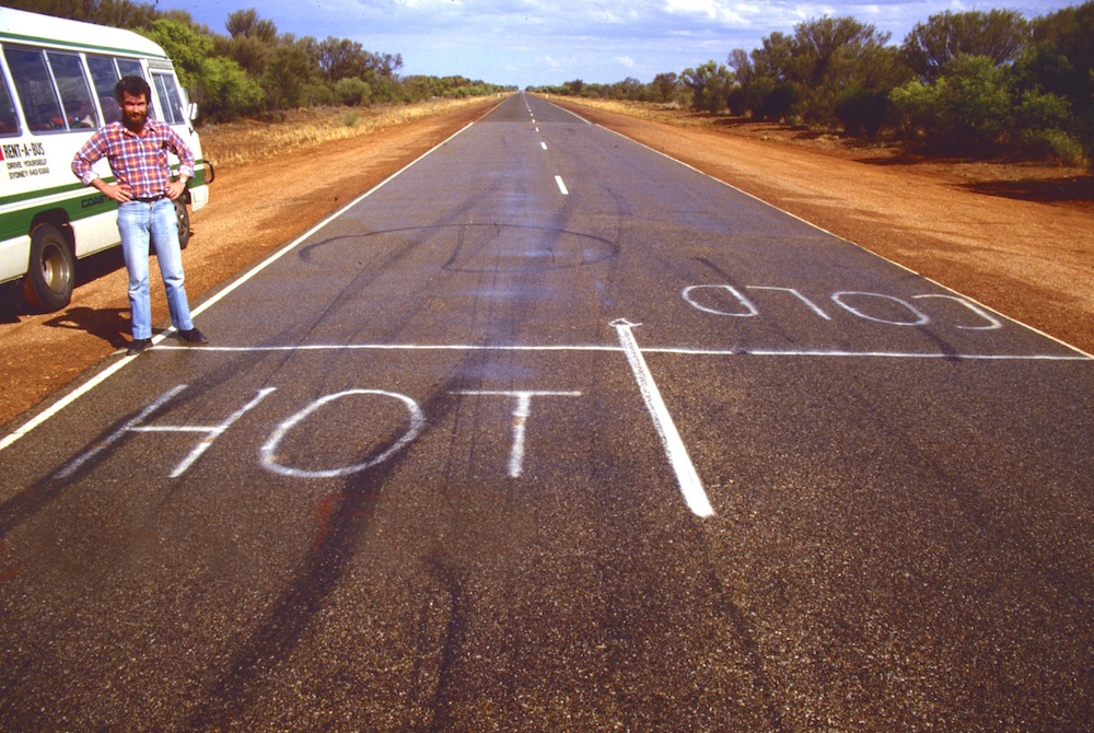
Along the way, we crossed from the tropics back into the sub-tropics. A sign marked the line of the Tropic of Capricorn but I liked what someone had painted on the road. (The man in the photo was one of the dads and you can see we had some rain.)
Schools and students have permission to use this graphic for non-commercial, educational purposes.
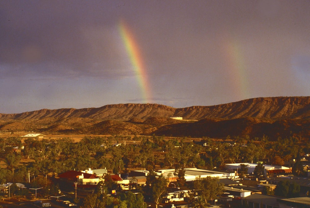
Finally, we arrived in Alice Springs, the town close to the middle of Australia if not really then in our minds. Again, as you can see in the photo, we were travelling in a wet period. The Todd River passes through Alice Springs but flowing water is rarely seen so, when they hold the Henley-on-Todd Regatta, it's more a running race holding something looking like a sailing boat. If the river is flowing with water, they have to cancel their boat races. 🙂
Schools and students have permission to use this graphic for non-commercial, educational purposes.
The MacDonnell Ranges are the mountains around Alice Springs. There are many gorges and beautiful rock formations to visit. Below is a photo of Standley Chasm. The people in the photo will give you an idea of the size of the chasm.
Schools and students have permission to use this graphic for non-commercial, educational purposes.
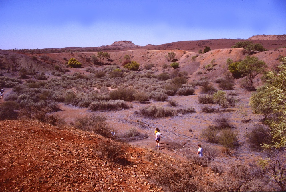
Heading south out of Alice Springs, we stopped at the Henbury Meteorite Craters. The twelve craters were formed when a meteorite broke into pieces before hitting the ground it's estimated about 4,700 years back.
Schools and students have permission to use this graphic for non-commercial, educational purposes.
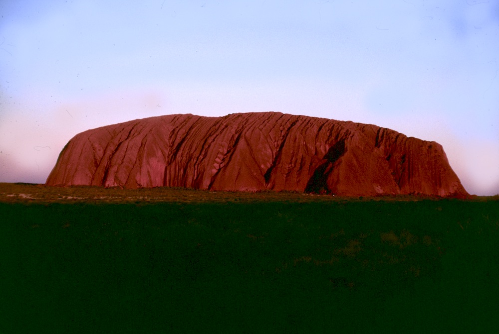
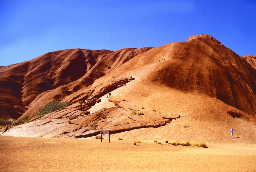
Finally, we came to our main aim for our tour, Uluru (Ayers Rock) and Kata Tjuta (The Olgas). Like Karlu Karlu, the sites have special significance to the local Aboriginal people who are the caretakers of the land. The first photo shows Uluru at sunset. It is the visible part of a huge monolith (single stone). The second photo shows the position where it's possible for visitors to climb the rock. The Aboriginal people wouldn't climb to the top of Uluru because of its cultural importance but they allow visitors if they choose to do so.
Schools and students have permission to use this graphic for non-commercial, educational purposes.Schools and students have permission to use this graphic for non-commercial, educational purposes.
As you walk or drive around the base of Uluru, there are many places with simple barriers and signs asking people to respect special places for Aboriginal people. There are sacred places for Aborginal men and women they ask visitors not to enter. The photo below shows some Aboriginal artwork on Uluru in a place where visitors can visit.
Schools and students have permission to use this graphic for non-commercial, educational purposes.
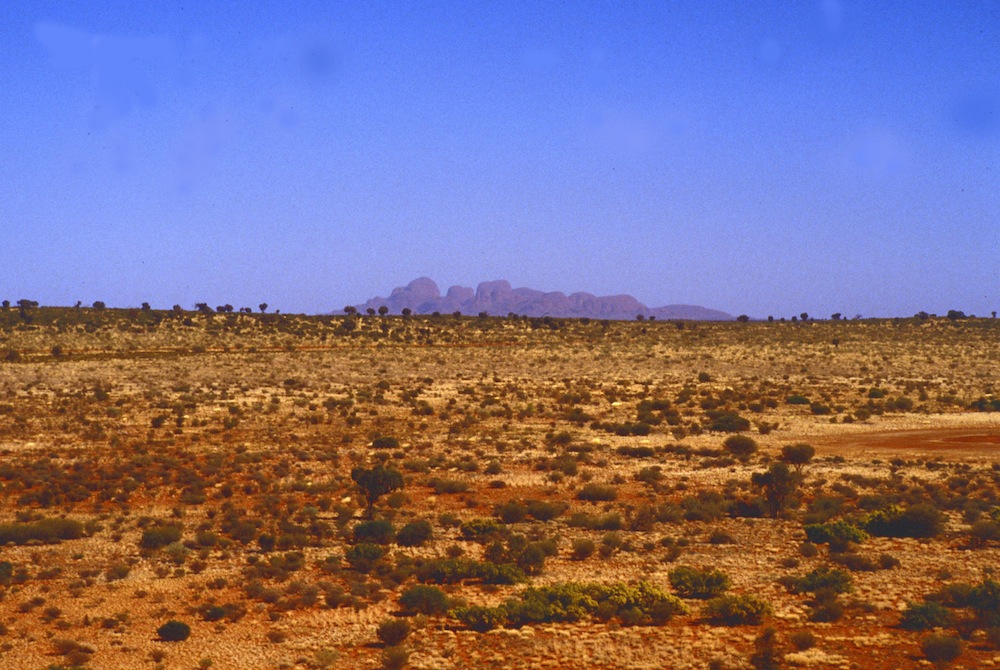
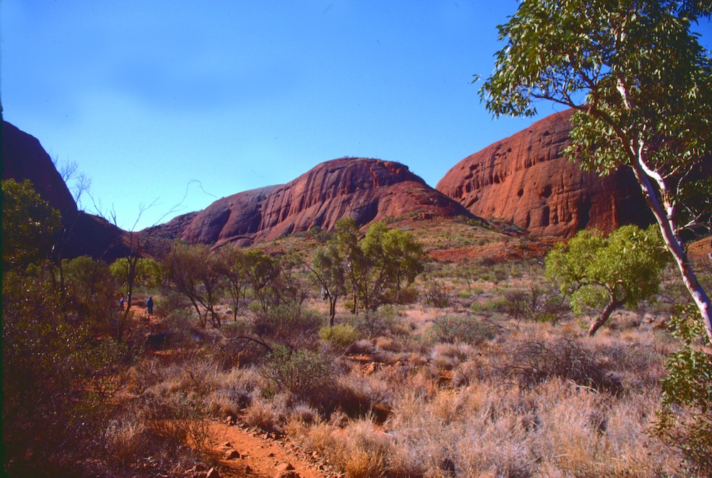
Approximately west of Uluru is Kata Tjuta (The Olgas). You can see them in the distance in the first photo taken from Uluru and part of them up close in the second and third.
Schools and students have permission to use this graphic for non-commercial, educational purposes.Schools and students have permission to use this graphic for non-commercial, educational purposes.Schools and students have permission to use this graphic for non-commercial, educational purposes.
Heading south from Uluru, we crossed into South Australia (S.A.).
Schools and students have permission to use this graphic for non-commercial, educational purposes.
...and eventually reached the opal mining town of Coober Pedy where many people have built their homes underground to protect them from summer heat. The area is dotted with opal mines.
Schools and students have permission to use this graphic for non-commercial, educational purposes.
We started to see salt lakes. Water flowing all the way from Queensland during high rainfall, has nowhere to go when reaching the lakes. As the water evaporates, salt is left behind. The next photo, taken from our bus, shows a salt lake in the distance.
Schools and students have permission to use this graphic for non-commercial, educational purposes.