Tag Archives: wallaby

To see the post written by Mrs. Yollis and her class once a surprise package arrived...

Meet Walter the Wombat

Wombats, Marsupials and Joeys

Following the arrival of a friendly wombat to Mrs. Yollis and her class in California, I wanted to share a couple extra photos.

Wombat

There are three species of wombat still to be found in Australia.

In my area, we see the common wombat (Vombatus ursinus). They are herbivores and live in burrows. Normally, they aren't see during the day but can be seen venturing out at dusk. I have seen them in the daytime but this is unusual. Unfortunately, wombats are sometimes killed when crossing roads but groups such as WIRES plus the staff at Potoroo Palace care for joeys if their mother is killed. The fathers don't take part in raising young. The photo below is of an orphaned wombat joey. It was in the care of Potoroo Palace staff. Potoroo Palace seeks to return injured and orphaned animals to the wild if at all possible.

One of Potoroo Palace's greatest wildlife heroes, and a friend, is Alexandra Seddon. She has devoted her life to wildife and the environment. A documentary of her life and care for the environment was just released. Click here to see the short about Alexandra and someof what she has achieved.

Alexandra Seddon

Schools and students have permission to use this graphic for non-commercial, educational purposes.

Schools and students have permission to use this graphic for non-commercial, educational purposes.

Wombats live in burrows.

Schools and students have permission to use this graphic for non-commercial, educational purposes.

Schools and students have permission to use this graphic for non-commercial, educational purposes.

Seems a little yucky but below is a photo of wombat droppings. They are easy to identify because they have a cubic shape.

Schools and students have permission to use this graphic for non-commercial, educational purposes.

Schools and students have permission to use this graphic for non-commercial, educational purposes.

I realised I hadn't added a video clip of wombats to my You Tube channel so I have added a brief one showing Bert the Wombat taken at Potoroo Palace back in 2011.

Kangaroos and Wallabies

Most people know of kangaroos and the smaller wallabies. Not only are some species native to my area, they sometimes feed on my front lawn and are an extra obstacle for golfers at a local golf course. Also marsupials, the females have pouches. They are not all the large kangaroos we see on TV. Here are just a few species.

Parma Wallaby  (Macropus parma) Taken at National Zoo in Camberra, Australia's capital city.

Schools and students have permission to use this graphic for non-commercial, educational purposes.

Schools and students have permission to use this graphic for non-commercial, educational purposes.


Tree Kangaroo Taken at National Zoo in Camberra, Australia's capital city. Yes it climbs. There are 12 species of tree kangaroo found in New Guinea and northern Australia. The photo is of a Goodfellow's Tree Kangaroo (Dendrolagus goodfellowi) and is found in New Guinea.

Schools and students have permission to use this graphic for non-commercial, educational purposes.

Schools and students have permission to use this graphic for non-commercial, educational purposes.

Eastern Grey Kangaroo (Macropus giganteus) - Very common in my area and sometimes have fed on my front lawn. The first photo shows females and joey too big for the pouch at Potoroo Palace. The second photo is of a male in the wild. He was about my height (183cm - 6').

Schools and students have permission to use this graphic for non-commercial, educational purposes.

Schools and students have permission to use this graphic for non-commercial, educational purposes.

Schools and students have permission to use this graphic for non-commercial, educational purposes.

Schools and students have permission to use this graphic for non-commercial, educational purposes.

This photo below shows Alexandra Seddon at Potoroo Palace. She is holding a swamp wallaby (wallabia bicolor). I see more of this species of wallaby thank eastern grey kangaroos.

Schools and students have permission to use this graphic for non-commercial, educational purposes.

Schools and students have permission to use this graphic for non-commercial, educational purposes.

Here is one of the short videos I have made showing the Eastern Grey Kangaroo at Potoroo Palace.

Koalas

Koalas (Phascolarctos cinereus) rival kangaroos as the best known Australian animals. The first photo is of Suzie the Koala and the second of Blinky at Potoroo Palace in 2011. They were the parents of Sapphire. Blinky and Suzie passed away a few years back but Sapphire lives on a now is a mother. The video shares a little of Sapphire's life and includes her emerging from Suzie's Pouch. The video clip was made over two years from 2011 to 2013.

Schools and students have permission to use this graphic for non-commercial, educational purposes.

Schools and students have permission to use this graphic for non-commercial, educational purposes.

Schools and students have permission to use this graphic for non-commercial, educational purposes.

Schools and students have permission to use this graphic for non-commercial, educational purposes.

Did you notice Suzie has a much larger and more defined white patch on the chest? This is a feature of females.

Other Marsupials - Antechinus

There are so many marsupial species in Australia apart from wombats, kangaroos, wallabies and koalas, too many to show here but I thought I would add a little about one of the smallest marsupials. The photo shows a mammal expert holding an antechinus in his hand. It was taken when I was recording activities in a local biological/environmental survey.

Antechinus are the size of mice and are often mistaken for them but they are true marsupials and females have a pouched area to carry young. Antechinus have pointier snouts than placental mice (common mouse).

Schools and students have permission to use this graphic for non-commercial, educational purposes.

Schools and students have permission to use this graphic for non-commercial, educational purposes.

5 Comments

Mrs. Todd and her Roadrunners are looking at Outback Australia. This is a post about an Outback journey I organised for parents and children from a school back in 1985. It's hard to believe those students would now be about 40 years old.

In this post, some video clips I had taken back in 1985 as my group travelled to Uluru and back have been shared. They have been converted from VHS tapes to digital and are being shared for the first time. 

The Australian Outback

I don't know exactly where The Outback is said to start but I've always understood it to be the more isolated, arid (desert-like) areas across the centre of Australia. Most Australians live in coastal areas although there are larger communities in some Outback areas including traditional land owners, miners and graziers (cattle ranchers).

Let's look at a satellite photo of Australia Wikimedia lists as NASA sourced and in the public domain...

This image was sourced through Wikimedia Commons where it has bee sourced from NASA and is listed in the public domain. http://commons.wikimedia.org/wiki/File:Australia_satellite_plane.jpg

This image was sourced through Wikimedia Commons where it has bee sourced from NASA and is listed in the public domain. http://commons.wikimedia.org/wiki/File:Australia_satellite_plane.jpg

If you look at this photo you can see green areas are mostly coastal whereas from the west (left on the photo) to most of the way east you see reds, browns and even white. The white areas, especially the very white areas are not snow. They tend to be salt lakes and high salt areas only filling with water when there are very heavy rains in Queensland. Once the water reaches the lakes, it has nowhere to go as the lakes lie below sea level. The water evaporates and leaves the salt behind.

Let's look at the journey my group took back in 1985. I was the tour organiser and minibus driver on our two week, 7000+km (4350+mi) journey into The Outback and back .


Schools and students have permission to use this graphic for non-commercial, educational purposes.

Schools and students have permission to use this graphic for non-commercial, educational purposes.

We started out in Sydney, the capital of the state on New South Wales and headed west then turned north to spend our first night in an isolated school where I had worked in the early 80s.

The school, Marra Creek Public School, is about 670km (415mi) from Sydney and lies 100km (62mi) from the nearest town of Nyngan. It served children from local sheep and cattle properties. I stayed at a neighbouring shearer's house about 20km (13mi) from the school.

Schools and students have permission to use this graphic for non-commercial, educational purposes.

Schools and students have permission to use this graphic for non-commercial, educational purposes.

Was the school in The Outback? It was isolated, used water from tanks, had a phone where you had to talk to an operator to be connected, and only sometimes could pick up one television station if the conditions were good. I sometimes had to chase emus and kangaroos or even wild pigs out of the playground.

Schools and students have permission to use this graphic for non-commercial, educational purposes.

Schools and students have permission to use this graphic for non-commercial, educational purposes.

A video clip of emus in an animal sanctuary close to my home.


And some kangaroos from the same sanctuary.


When I first started there we had been in drought and the water tanks were low, temperatures at times reached 47C (116F). With rains, the clay pans turned green with grass and roads became muddy. We didn't have snow days but we did have mud days when half of the students couldn't make it along the dirt roads. We didn't build mud men. Snow seems to work better and is cleaner.

Heading across country, we visited the town of Bourke most would consider an outback town. It lies along the Darling River, a river sometimes drying out if rains don't fall in Queensland and can also flood when heavy rainfall comes. On our trip, rainfall in the outback had been unusually good but still low compared to coastal.

Schools and students have permission to use this graphic for non-commercial, educational purposes.

Schools and students have permission to use this graphic for non-commercial, educational purposes.

Not too far north of Bourke, we crossed into the state of Queensland. You can see in the photo below just how flat and semi-arid (almost desert) much of inland Australia can be.

Schools and students have permission to use this graphic for non-commercial, educational purposes.

Schools and students have permission to use this graphic for non-commercial, educational purposes.

Heading north, we were heading towards the town of Longreach. The landscape had dried out.

Schools and students have permission to use this graphic for non-commercial, educational purposes.

Schools and students have permission to use this graphic for non-commercial, educational purposes.

Stopping for the night, we were entertained by brolgas, the only cranes native to Australia. While at Marra Creek Public School, I had watched brolgas "dancing" their mating dance as they made jumps into the air.

Schools and students have permission to use this graphic for non-commercial, educational purposes.

Schools and students have permission to use this graphic for non-commercial, educational purposes.

The video clip below isn't one of mine but shows the dance of the brolgas.

Just north of Longreach, we crossed the Tropic of Capricorn. This means we were now in the tropical region of the world.

Near Longreach we saw an echidna on the side of the road. Echidnas and the platypus are the world's only living mammals that lay eggs but, as they are mammals, the mothers can give milk to their young. Echidnas are also found around my town and have sometimes visited my garden in search of ants.

Schools and students have permission to use this graphic for non-commercial, educational purposes.

Schools and students have permission to use this graphic for non-commercial, educational purposes.

Below is a video of an echidna taken at an animal sanctuary near my home.

Our next major settlement was Mount Isa (pictured below), a mining town in western Queensland. Lead, silver, copper and zinc are mined in the Mount Isa area.

Schools and students have permission to use this graphic for non-commercial, educational purposes.

You can easily see the red of the soil, a soil colour so common in The Outback.

From Mt. Isa, we head west to the border with Northern Territory. The photo below was taken standing in the state of Northern Territory looking into Queensland.

Schools and students have permission to use this graphic for non-commercial, educational purposes.

Schools and students have permission to use this graphic for non-commercial, educational purposes.

Reaching the Stuart Highway, a highway running from Adelaide, the capital of the state of South Australia, in the south to Darwin, Northern Territory's capital, in the north, we took a left turn because we had reached as far north as we were going on this journey.

Passing through the town of Tennant Creek,  our next major attraction was Karlu Karlu (known also as the Devil's Marbles) 105km (65mi) south of Tennant Creek. Here are some photos taken at Karlu Karlu.

Schools and students have permission to use this graphic for non-commercial, educational purposes.

Schools and students have permission to use this graphic for non-commercial, educational purposes.

Schools and students have permission to use this graphic for non-commercial, educational purposes.

Schools and students have permission to use this graphic for non-commercial, educational purposes.

That's not me pretending to hold up the rock.

The video clip below was taken on the 1985 trip and has been converted to digital and shared for the first time.

Karlu Karlu is a sacred site to the Alyawarre (Aboriginal) whose country includes the site. It's also sacred to the Kaytetye, Warumungu and Warlpiri people. There are a number of traditional Dreaming stories for the Karlu Karlu area but only a few are able to be shared with uninitiated people such as us.

From Karlu Karlu, we continued south towards Alice Springs. As we travelled, we again crossed the Tropic of Capricorn, this time heading out of the tropics. Someone with a sense of humour had painted words on the road (not us).

Schools and students have permission to use this graphic for non-commercial, educational purposes.

Schools and students have permission to use this graphic for non-commercial, educational purposes.

Schools and students have permission to use this graphic for non-commercial, educational purposes.

Schools and students have permission to use this graphic for non-commercial, educational purposes.

Alice Springs is the largest town in Central Australia and the third largest in Northern Territory. Central Australia is only a name for the area and is not a state. To the local people, the Arrernte, the Alice Springs area is known as Mparntwe.

On our visit, we managed to see a rare rainbow over Alice Springs.

Schools and students have permission to use this graphic for non-commercial, educational purposes.

Schools and students have permission to use this graphic for non-commercial, educational purposes.

Alice Springs lies within the MacDonnell Ranges. There are so many beautiful places to visit in this arid area. Here are just two...

Standley Chasm

Schools and students have permission to use this graphic for non-commercial, educational purposes.

Schools and students have permission to use this graphic for non-commercial, educational purposes.

The video clip of Standley Chasm below was taken on the 1985 trip and has been converted to digital and shared for the first time.


Simpsons Gap (it was late in the day)

Schools and students have permission to use this graphic for non-commercial, educational purposes.

Schools and students have permission to use this graphic for non-commercial, educational purposes.

The video clip of Simpsons Gap below was taken on the 1985 trip and has been converted to digital and shared for the first time.

The video clip of black-footed rock wallabies below was taken on the 1985 trip and has been converted to digital and shared for the first time. The rock wallabies were our companions as we explored Simpsons Gap.

After leaving Alice Springs, we took time for a camel ride. Camels aren't native to Australia but were brought here by Afghan camel herders in the 1800s. Before roads and railways, all supplies had to be brought in by camel trains. When road and rail arrived, many camels were released into the wild. Australia now is the country with the largest number of wild camels in the world and at times exports camels back to the Middle East.

Schools and students have permission to use this graphic for non-commercial, educational purposes.

Schools and students have permission to use this graphic for non-commercial, educational purposes.

The video clip of camel riding below was taken on the 1985 trip and has been converted to digital and shared for the first time.

We were heading to Uluru and Kata Tjuta. Along the arid way, we saw Mount Conner standing high above the desert.

Schools and students have permission to use this graphic for non-commercial, educational purposes.

Schools and students have permission to use this graphic for non-commercial, educational purposes.

Tourists to Central Australia shouldn't miss a chance to see  Uluru and Kata Tjuta. Here are some photos I had taken.

Uluru (aka Ayers Rock) at sunset

Schools and students have permission to use this graphic for non-commercial, educational purposes.

Schools and students have permission to use this graphic for non-commercial, educational purposes.

Uluru (aka Ayers Rock) at sunset

Schools and students have permission to use this graphic for non-commercial, educational purposes.

Schools and students have permission to use this graphic for non-commercial, educational purposes.

Uluru (aka Ayers Rock) up close

You can get an idea of its size by looking at the people climbing it.

Schools and students have permission to use this graphic for non-commercial, educational purposes.

Schools and students have permission to use this graphic for non-commercial, educational purposes.

And a view from almost the top of Uluru

Schools and students have permission to use this graphic for non-commercial, educational purposes.

Schools and students have permission to use this graphic for non-commercial, educational purposes.

Since my visit 30 years ago, visitors have become much more aware of the importance of Uluru to the local people. While they don't stop visitors climbing the rock, many visitors now choose not to climb in respect for the beliefs of the local people.

The video clip of an Uluru sunset below was taken on the 1985 trip and has been converted to digital and shared for the first time. It is running at 20x normal speed.

Around the base of Uluru, there are many sacred sites we are asked to respect. Some are sacred men's sites and some sacred women's sites.

Schools and students have permission to use this graphic for non-commercial, educational purposes.

Schools and students have permission to use this graphic for non-commercial, educational purposes.

However, there are sites visitors can see. Here is a photo taken at one such site, Mutitjula (Maggie Springs). You can see some of the rock paintings.

Schools and students have permission to use this graphic for non-commercial, educational purposes.

Schools and students have permission to use this graphic for non-commercial, educational purposes.

From Uluru, it is possible to see the distant Kata Tjuta rising from the desert plain.

Schools and students have permission to use this graphic for non-commercial, educational purposes.

Schools and students have permission to use this graphic for non-commercial, educational purposes.

Back in our mini-bus, we headed along the dirt road to Kata Tjuta.

Schools and students have permission to use this graphic for non-commercial, educational purposes.

Schools and students have permission to use this graphic for non-commercial, educational purposes.


Schools and students have permission to use this graphic for non-commercial, educational purposes.

Schools and students have permission to use this graphic for non-commercial, educational purposes.

On leaving Uluru and Kata Tjuta, we rejoined the Stuart Highway and again headed south crossing the state border into South Australia.

Schools and students have permission to use this graphic for non-commercial, educational purposes.

Schools and students have permission to use this graphic for non-commercial, educational purposes.

Our next stop would be Coober Pedy, famous for its opal mined in the area. Because of the high temperatures on summer days, some homes in Coober Pedy have been built underground.

Schools and students have permission to use this graphic for non-commercial, educational purposes.

Schools and students have permission to use this graphic for non-commercial, educational purposes.

Heading further south, we started to see salt lakes near the road. As they are lower than the distant sea, water entering can't flow out. The water evaporates and leaves the salt behind. You can see a late afternoon photo of a salt lake.

Schools and students have permission to use this graphic for non-commercial, educational purposes.

Schools and students have permission to use this graphic for non-commercial, educational purposes.

There were many kilometres of flat roads as we continued south.

Schools and students have permission to use this graphic for non-commercial, educational purposes.

Schools and students have permission to use this graphic for non-commercial, educational purposes.

On reaching Port Augusta in South Australia, we headed east and back to Sydney. We had travelled over 7000+km (4350+mi) in our journey through The Outback.

2 Comments

In the comments of their poster entitled "Welcome to Grade THREE!", the Battalion Bloggers asked some questions. For their original post...

Welcome to Grade THREE!

Monitor Lizards

Perentie Lizards

This graphic has been sourced through Wikimedia Commons and is listed as in the public domain.

This graphic has been sourced through Wikimedia Commons and is listed as in the public domain.

The Perentie tend to live in central Australia across to Western Australia but are not native to my area. Their patterning is very attractive but I have only seen them in zoos and not in the wild. They are one of the monitor lizards.

 Lace Monitors

 The photo below shows a local lace monitor (goanna) I photographed while hiking. It was about 1.5m long and was seen eating an animal killed on the road. I have seen them a number of times.

Lace monitors are our second largest monitor lizards after the perentie. The perentie and lace monitor are thought to be slightly venomous but they are generally shy and run away if surprised. I have read fossils have been found in Australia showing komodo dragons, the largest of the monitors once also roamed Australia but are now only found in Indonesia.

Schools and students have permission to use this graphic for non-commercial, educational purposes.

Schools and students have permission to use this graphic for non-commercial, educational purposes.

Kangaroo, Koalas and Echidnas

I have seen kangaroos (and wallabies), koalas and echidnas in zoos and in the wild a number of times. There has been an echidna in my garden and kangaroos on the sports oval across the road. While wild koalas aren't common in my area, my local animal sanctuary has had them. Potoroo Palace has a female named Sapphire who was born in their sanctuary. I have known her since birth.

All of the video clips shown below were filmed by me at Potoroo Palace.

Kangaroo

The most common kangaroo in my area is the eastern grey kangaroo. The males can be up to around 2m tall and are common in my area. The pictured male was as tall as me. He watched me as I took his photo them he hopped away. They are only dangerous if they feel trapped.

Schools and students have permission to use this graphic for non-commercial, educational purposes.

Schools and students have permission to use this graphic for non-commercial, educational purposes.

Here is one of my short video clips showing eastern grey kangaroos.

Koala

The photo shows Sapphire when she was younger but had left her mother's pouch.

Schools and students have permission to use this graphic for non-commercial, educational purposes.

Schools and students have permission to use this graphic for non-commercial, educational purposes.

The first of my video clips shows one of the first times Sapphire looked out from her mother's pouch after about 26 weeks inside the pouch.

The second clip shows Sapphire with her mother, Suzie. Too big, Sapphire stayed out of the pouch but with her mother.

With the loss of Blinky (father) and Suzie (mother), Sapphire is now the only koala at Potoroo Palace. I am certain the staff will be hoping for a suitable mate for her to continue their koala breeding.

Echidna

 I have seen echidna when hiking, in a park in my town and even in my own backyard. Their eyesight isn't good and they can't bite. If threatened, they dig their strong claws into the ground, hold on, and show only their spines.

Schools and students have permission to use this graphic for non-commercial, educational purposes.

Schools and students have permission to use this graphic for non-commercial, educational purposes.

This is what they look like when they dig in.

Schools and students have permission to use this graphic for non-commercial, educational purposes.

Schools and students have permission to use this graphic for non-commercial, educational purposes.


 Below is a video clip of Potoroo Palace's Spike.

The Outback.

There was an old saying, "Out back of Bourke". Others have talked about the outback starting at the dingo fence or  beyond the  "black stump", or a number of other areas but, mostly, outback refers to isolated inland areas of Australia. Unlike Canada, much of Australia is arid or semi-arid (deserts or near deserts) where rainfall is low and the soil is often reddish from iron oxides (rust). I'll share some photos, a number just scanned into the computer from old 35mm film slides, so you'll be the first to see them since many were taken back in 1985.

In 1981 and 1982 I was the Teacher in Charge of a one teacher school. It was very isolated and ranked number 6 in our state. Town was 100km away. The school was there for children from sheep and cattle stations. I lived 20km distant in a shearer's quarters on a 100,000 acre sheep station. We did have a computer on loan for about six weeks each year but the internet was still many years away for schools.

Below is a picture from 1982. Does it look isolated?

Schools and students have permission to use this graphic for non-commercial, educational purposes.

Schools and students have permission to use this graphic for non-commercial, educational purposes.

1985 - A Trip to Uluru (Ayers Rock)

By 1985, I was a teacher in an 850 student school in western Sydney. In 1983, I had organised a trip for some families to New Zealand but, for 1985, organised a trip through the centre of Australia. I was the 20 seater bus driver for most of the trip of over 7000km. Our first night was spent in the schoolroom of my old school pictured above. From there, we took dirt roads and a main highway until we reached Bourke. From there, we could have said we were in the outback.

Schools and students have permission to use this graphic for non-commercial, educational purposes.

Schools and students have permission to use this graphic for non-commercial, educational purposes.

Here are some photos from back then...

This is the Darling River in the town of Bourke. The Darling River is part of an inland water system stretching from Queensland through New South Wales (N.S.W.), Victoria and out to sea in South Australia(S.A.). In times of severe drought it can run dry or overflow in flood during big rain.

Schools and students have permission to use this graphic for non-commercial, educational purposes.

Schools and students have permission to use this graphic for non-commercial, educational purposes.

Heading north from Bourke along the Mitchell Highway, we stopped at the state border between N.S.W. and Queensland. The countryside was very flat but green as we had some rain the week before our trip.

Schools and students have permission to use this graphic for non-commercial, educational purposes.

Schools and students have permission to use this graphic for non-commercial, educational purposes.

 We came to the mining town of Mt. Isa in Queensland. Mt. Isa is in the tropical but dry north of Australia. The red colouring of the soil is caused by iron oxide (rust) in the soil. Lead, silver, copper and zinc is mined there.

Schools and students have permission to use this graphic for non-commercial, educational purposes.

Schools and students have permission to use this graphic for non-commercial, educational purposes.

From Mt. Isa, we headed west and crossed into the Northern Territory, heading about half way across N.T.. before heading south to the Red Centre (the middle of Australia). One of our stops was at Karlu Karlu (Devil's Marbles) where there are many large rocks seemingly balanced on their ends. They are important in traditional Aboriginal beliefs.

Schools and students have permission to use this graphic for non-commercial, educational purposes.

Schools and students have permission to use this graphic for non-commercial, educational purposes.

Along the way, we crossed from the tropics back into the sub-tropics. A sign marked the line of the Tropic of Capricorn but I liked what someone had painted on the road. (The man in the photo was one of the dads and you can see we had some rain.)

Schools and students have permission to use this graphic for non-commercial, educational purposes.

Schools and students have permission to use this graphic for non-commercial, educational purposes.

Finally, we arrived in Alice Springs, the town close to the middle of Australia if not really then in our minds. Again, as you can see in the photo, we were travelling in a wet period. The Todd River passes through Alice Springs but flowing water is rarely seen so, when they hold the Henley-on-Todd Regatta, it's more a running race holding something looking like a sailing boat. If the river is flowing with water, they have to cancel their boat races. 🙂

Schools and students have permission to use this graphic for non-commercial, educational purposes.

Schools and students have permission to use this graphic for non-commercial, educational purposes.

The MacDonnell Ranges are the mountains around Alice Springs. There are many gorges and beautiful rock formations to visit. Below is a photo of Standley Chasm. The people in the photo will give you an idea of the size of the chasm.

Schools and students have permission to use this graphic for non-commercial, educational purposes.

Schools and students have permission to use this graphic for non-commercial, educational purposes.

Heading south out of Alice Springs, we stopped at the Henbury Meteorite Craters. The twelve craters were formed when a meteorite broke into pieces before hitting the ground it's estimated about 4,700 years back.

Schools and students have permission to use this graphic for non-commercial, educational purposes.

Schools and students have permission to use this graphic for non-commercial, educational purposes.

Finally, we came to our main aim for our tour, Uluru (Ayers Rock) and Kata Tjuta (The Olgas). Like Karlu Karlu, the sites have special significance to the local Aboriginal people who are the caretakers of the land. The first photo shows Uluru at sunset. It is the visible part of a huge monolith (single stone). The second photo shows the position where it's possible for visitors to climb the rock. The Aboriginal people wouldn't climb to the top of Uluru because of its cultural importance but they allow visitors if they choose to do so.

Schools and students have permission to use this graphic for non-commercial, educational purposes.

Schools and students have permission to use this graphic for non-commercial, educational purposes.

Schools and students have permission to use this graphic for non-commercial, educational purposes.

Schools and students have permission to use this graphic for non-commercial, educational purposes.

As you walk or drive around the base of Uluru, there are many places with simple barriers and signs asking people to respect special places for Aboriginal people. There are sacred places for Aborginal men and women they ask visitors not to enter. The photo below shows some Aboriginal artwork on Uluru in a place where visitors can visit.

Schools and students have permission to use this graphic for non-commercial, educational purposes.

Schools and students have permission to use this graphic for non-commercial, educational purposes.

Approximately west of Uluru is Kata Tjuta (The Olgas). You can see them in the distance in the first photo taken from Uluru and part of them up close in the second and third.

Schools and students have permission to use this graphic for non-commercial, educational purposes.

Schools and students have permission to use this graphic for non-commercial, educational purposes.

Schools and students have permission to use this graphic for non-commercial, educational purposes.

Schools and students have permission to use this graphic for non-commercial, educational purposes.

Schools and students have permission to use this graphic for non-commercial, educational purposes.

Schools and students have permission to use this graphic for non-commercial, educational purposes.

Heading south from Uluru, we crossed into South Australia (S.A.).

Schools and students have permission to use this graphic for non-commercial, educational purposes.

Schools and students have permission to use this graphic for non-commercial, educational purposes.

...and eventually reached the opal mining town of Coober Pedy where many people have built their homes underground to protect them from summer heat. The area is dotted with opal mines.

Schools and students have permission to use this graphic for non-commercial, educational purposes.

Schools and students have permission to use this graphic for non-commercial, educational purposes.

We started to see salt lakes. Water flowing all the way from Queensland during high rainfall, has nowhere to go when reaching the lakes. As the water evaporates, salt is left behind. The next photo, taken from our bus, shows a salt lake in the distance.

Schools and students have permission to use this graphic for non-commercial, educational purposes.

Schools and students have permission to use this graphic for non-commercial, educational purposes.

Upon reaching the town of Port Augusta, we headed north-east through the Flinders Ranges.

Schools and students have permission to use this graphic for non-commercial, educational purposes.

Schools and students have permission to use this graphic for non-commercial, educational purposes.

We crossed the border into N.S.W. and travelled 1200km to reach home.

Schools and students have permission to use this graphic for non-commercial, educational purposes.

Schools and students have permission to use this graphic for non-commercial, educational purposes.


For Techie Kids and their post

Hello Techie Kids,

After looking at your post and your "Michigan Animals" book, I looked at the your questions. When I came to, "What animals live in your area or are unique to your area?" I wondered what more I could share as you have seen many of my animal photos.

Yesterday morning I was walking along Tura Beach North not far from my home, I was taking more photos for my photo library. Looking through these, I had an idea. I have shown animals but what about their tracks? When hiking, I sometimes see tracks left by animals whether lizards, snakes, birds or mammals. It's interesting to see them and guess what animal left them behind. Sometimes I can follow the trails and sometimes I find only a few tracks. Here are some photos.

This is Tura Beach looking north towards Bournda National Park. There are many tracks but mostly human. Can you see the wallaby tracks in the sand?

Schools and students have permission to use this graphic for non-commercial, educational purposes.

Location: North Tura Beach, N.S.W., Australia

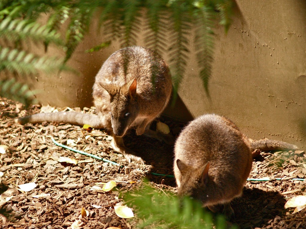
Below is the track left behind a swamp wallaby (Wallabia bicolor). It wasn't hopping. It was walking. When doing this, they place their front paws on the ground then bring forward their large hind legs while dragging their tail along the ground. In the bottom right hand corner of the beach photo you might be able to see where a wallaby had been. If I hadn't seen the paw prints, I might have thought this was the track of a snake. If the paw prints had been small and clawed, it might have been a monitor lizard (goanna).

  Schools and students have permission to use this graphic for non-commercial, educational purposes.

Location: North Tura Beach, N.S.W., Australia

These are the tracks are of a bird. Judging by their size and shape I knew they were from a smaller bird. I suspected they might be the prints of a bird like the pied oyster catcher (Haematopus longirostris).

Schools and students have permission to use this graphic for non-commercial, educational purposes.

Location: North Tura Beach, N.S.W., Australia

The next track was a little easier. It was reasonably large (you can see the sand grains are larger in this close up shot than the one above). I believe this is the rear paw print of a common wombat (Vombatus ursinus).

Schools and students have permission to use this graphic for non-commercial, educational purposes.

Location: North Tura Beach, N.S.W., Australia

The following tracks are the easiest for me. I see them so often. They were too small to be a kangaroo. No tail or front paw marks were in the sand, they are the prints of a hopping swamp wallaby.

Schools and students have permission to use this graphic for non-commercial, educational purposes.

Location: North Tura Beach, N.S.W., Australia

I think these are the prints of a wombat, both front and rear feet.

Schools and students have permission to use this graphic for non-commercial, educational purposes.

Location: North Tura Beach, N.S.W., Australia

I don't think I need to tell you what animal made this print. While its track can be found at any time of the year, it is most common to find at beaches on hot summer's days. This was from an adult. The size and depth of the footprint showed it was not a child.

Schools and students have permission to use this graphic for non-commercial, educational purposes.

Location: North Tura Beach, N.S.W., Australia

Judging by the shape, size and depth of this print, I suspect this animal was about 185cm (6ft 1in) tall and goes by the name of Ross.

Schools and students have permission to use this graphic for non-commercial, educational purposes.

Location: North Tura Beach, N.S.W., Australia

I'm sure you have seen this one. It's the print of a small dog. You can see there had been some rain overnight but as the print doesn't show any signs of raindrops, it had probably been on the beach not too long before I arrived.

Schools and students have permission to use this graphic for non-commercial, educational purposes.

Location: North Tura Beach, N.S.W., Australia

This is the print of another bird. Its size suggests something the size of a seagull but I can't see any sign of webbing between the toes so it couldn't be a seagull or small duck. It is larger than the bird prints above so it isn't something like a pied oyster catcher. Perhaps its from a masked lapwing (plover).

Schools and students have permission to use this graphic for non-commercial, educational purposes.

Location: North Tura Beach, N.S.W., Australia

 The tracks left behind by animals can sometimes tell a story. If we follow them we may see where they stopped to search for food or rested. Have any of you photographed the tracks of animals?